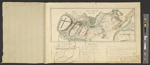
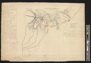
Sketch of part of the road from Freehold to Midde Town shewing the skirmish between the rear of the British army under the command of his excellency Genl. Sir Henry Clinton and the advanced corps of the rebel army June 28th 1778
This map is also available in American Revolutionary Geographies Online (ARGO), a collections portal especially built for material relating to the American Revolutionary War Era. Visit ARGO to learn more about this item and explore the historical geography of North America in the late eighteenth century.
Item Information
- Title:
- Sketch of part of the road from Freehold to Midde Town shewing the skirmish between the rear of the British army under the command of his excellency Genl. Sir Henry Clinton and the advanced corps of the rebel army June 28th 1778
- Title (alt.):
-
Sketch of Middle Town
- Creator:
- Hills, John, active 1777-1819
- Contributor:
- Clinton, Henry, Sir, 1738?-1795
- Date:
-
1778
- Format:
-
Maps/Atlases
- Genre:
-
Manuscript maps
- Location:
- William L. Clements Library
- Collection (local):
-
William L. Clements Library Collection
- Subjects:
-
Monmouth, Battle of, Freehold, N.J., 1778--Maps
Freehold (N.J.)--Maps
Middletown (N.J.)--Maps
United States--History--Revolution, 1775-1783--Maps
- Places:
-
New JerseyMonmouth (county)Freehold
New JerseyMonmouth (county)Middletown
- Extent:
- 1 ms. map : col. ; 49.8 x 68.7 cm.
- Terms of Use:
-
The University of Michigan Library provides access to these materials for educational and research purposes. These materials may be under copyright. If you decide to use any of these materials, you are responsible for making your own legal assessment and securing any necessary permission. If you have questions about the collection, please contact the William L. Clements Library.
Contact host institution for more information.
- Scale:
-
Scale of 800 paces to an inch.
- Language:
-
English
- Catalog Record:
-
Catalog record
- Notes:
-
Finished, colored, topographical map showing one phase of the Battle of Monmouth.
Inside neat line at lower right: Copied from I Hills sketch by IH.
Shows positions of some units.
Includes several manuscript notations by Sir Henry Clinton.
Clinton Map 239.
- Identifier:
-
8384
- Barcode:
-
B2795432