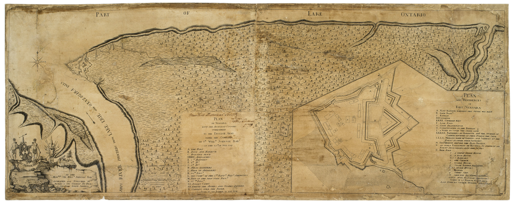
Plan of Niagara with the adjacent country surrendered to the English army under the command of Sr. Willm: Johnson Bart: on the 25th of July 1759
This map is also available in American Revolutionary Geographies Online (ARGO), a collections portal especially built for material relating to the American Revolutionary War Era. Visit ARGO to learn more about this item and explore the historical geography of North America in the late eighteenth century.
Item Information
- Title:
- Plan of Niagara with the adjacent country surrendered to the English army under the command of Sr. Willm: Johnson Bart: on the 25th of July 1759
- Cartographer:
- Demler, George
- Engraver:
- De-Bruhls, Michael, fl. 1757-1763
- Publisher:
- De-Bruhls, Michael, fl. 1757-1763
- Engraver:
- De-Bruhls, Godhart
- Publisher:
- De-Bruhls, Godhart
- Date:
-
[1762]
- Format:
-
Maps/Atlases
- Location:
- New-York Historical Society
- Collection (local):
-
New-York Historical Society Collection
- Subjects:
-
Old Fort Niagara (N.Y.)--Maps
Old Fort Niagara (N.Y.)--Siege, 1759--Maps
Niagara River (N.Y. and Ont.)--Maps
United States--History--French and Indian War, 1754-1763--Maps
Johnson, William, 1715-1774
- Places:
-
Niagara (county)Old Fort Niagara
- Extent:
- 1 map on two sheets ; 32 x 87 cm.
- Terms of Use:
-
No known copyright restrictions.
No known restrictions on use.
- Publisher:
-
New York :
Engraved and published by Michael & son Godhart De-Bruls
- Scale:
-
Scale 1:7,200
- Language:
-
English
- Catalog Record:
-
https://library.nyu.edu/persistent/lcn/nyu_aleph005870121?institution=NYU&persistent
- Notes:
-
Key identifies details of siege of Fort Niagara.
Inset: Plan and references of Fort Niagara.
Key on inset plan identifies features of Fort Niagara.
Ornate cartouche incorporates arms of Sir William Johnson.
- Notes (date):
-
This date is inferred.
- Identifier:
-
81935d_PlanNiagara1759_NS4M31_5_14