Toggle navigation
LMEC Home
Exhibitions
Georeferencing
Tools for Teachers
Collections
My Favorites
Sign Up / Log In
Search
Search the map portal
Map Collection
Map Collection
Map Sets
Search
Search
Search for
Search In
All Fields
Creator
Title
Subject
Place
Search All Digital Collections
Advanced Search
376 Results
My Search
Start Over
More Like
commonwealth:hx11z525b
Remove constraint More Like: commonwealth:hx11z525b
Filter your Search
Place
North and Central America
335
United States
209
Canada
103
Essex (county)
24
Louisbourg
21
Saint Lawrence River
19
Suffolk (county)
16
Warren (county)
16
more
Place
»
Topic
United States--History--French and Indian War, 1754-1763--Maps, Manuscript--Early works to 1800
57
Louisbourg (N.S.)--Maps, Manuscript--Early works to 1800
18
Fort Edward (N.Y.)--Maps, Manuscript--Early works to 1800
15
Fort Ticonderoga (N.Y.)--Maps, Manuscript--Early works to 1800
15
Saint Lawrence River--Maps, Manuscript--Early works to 1800
15
Louisbourg (N.S.)--History--Siege, 1745--Maps, Manuscript--Early works to 1800
14
Fortification--New York (State)--Maps, Manuscript--Early works to 1800
13
Fortification--New York (State)--Fort Edward--Maps, Manuscript--Early works to 1800
12
more
Topic
»
Date
Date range begin
–
Date range end
Current results range from
1664
to
1816
View distribution
Creator
Royal United Services Institute for Defence and Security Studies
160
George, III, King of Great Britain, 1738-1820
151
George, IV, King of Great Britain, 1762-1830
150
Amherst, Jeffery Amherst, Baron, 1717-1797
128
Skinner, Monier
28
Skinner, William, 1700-1780
28
Brasier, William
16
Bastide, John Henry, approximately 1700-1770
15
more
Creator
»
Format
Maps/Atlases
359
Manuscripts
149
Drawings/Illustrations
15
Georeferenced
Yes
7
No
369
Collection
British Library Collection
376
American Revolutionary War-Era Maps
352
Boston and New England Maps
21
Urban Maps
5
Maritime Charts and Atlases
2
Available to use
Creative Commons license
376
Search Constraints
Sort by title
relevance
title
date (asc)
date (desc)
Number of results to display per page
50 per page
10
per page
20
per page
50
per page
100
per page
View results as:
grid view
map view
Search Results
301.
Plan of the Town and Harbour of Louisbourg
302.
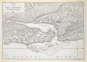
PLAN of the TOWN and HARBOUR of S.T AUGUSTIN
303.
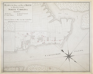
PLAN of the Town and Port of BATH in Beaufort County NORTH CAROLINA
304.
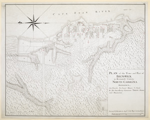
PLAN of the Town and Port of BRUNSWICK in Brunswick County. NORTH CAROLINA
305.
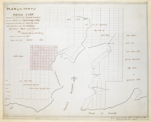
PLAN of the TOWN of BELLE VIEU situated on the East side Beaver Harbour in the District of Passamaquoddy
306.
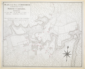
PLAN of the Town of CROSS CREEK in Cumberland County. NORTH CAROLINA
307.
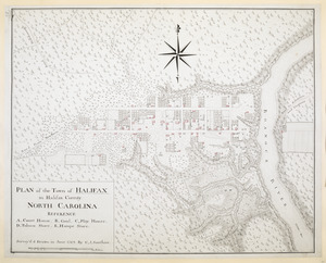
PLAN of the Town of HALIFAX in Halifax County. NORTH CAROLINA
308.
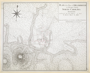
PLAN of the Town of HILLSBOROUGH in Orange County NORTH CAROLINA
309.
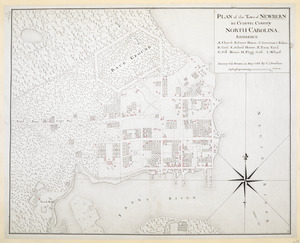
PLAN of the Town of NEWBERN in Craven County NORTH CAROLINA
310.
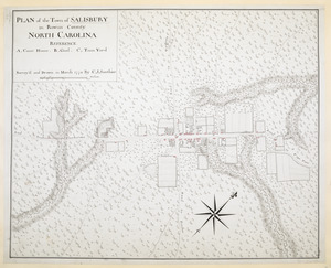
PLAN of the Town of SALISBURY in Rowan County. NORTH CAROLINA
311.
PLAN Of the Town of SAVANNAH, Showing the Works Constructed for its Defence; also, The Approaches and Batteries of the Enemy:...
312.
PLAN of The TOWN of SHELBURNE projected and laid out By Order of his Excell,y IOHN PARR Esqr Capt,n Gen,l Governor & Commander...
313.
A PLAN of the TOWN of St ANDREWS Situated at the Head of Passamaquoddy Bay-laid out for the Accomodation of Loyal Emigrants &...
314.
A PLAN OF THE TOWN OF ST. GEORGE Situated in Harbor Etang on the North side the Bay of Fundy, projected and laid out under the...
315.
PLAN of the Town of WILLMINGTON in New Hanover County NORTH CAROLINA
316.
A Plan of the Wooden Peer built in Lake George by Col. Bagly in novemb:r 1756 Which he charged Genr:l Winslow 60:L for
317.
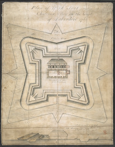
Plan of York Fort erected at Chateaux bay on the Coast of Labradore 1766
318.
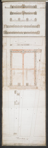
Plans & Sections of Houses for Officers & Barracks for Soldiers near the City of Philadelphia
319.
Plans & Sections of Houses for Officers & Barracks for Soldiers near the City of Philadelphia
320.
Plans & Sections of Houses for Officers & Barracks for Soldiers near the City of Philadelphia
321.
The Profil belonging to the Iconographycal Draft of the Fort William & Mary on Piscataqua River in America
322.
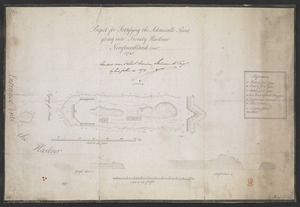
Project for Fortifying the Admiralls Point going into Trinity Harbour Newfoundland Octob.r 1745
323.
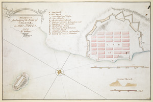
PROJECT for Fortifying the Town of HALLIFAX ; in NOVA SCOTIA
324.
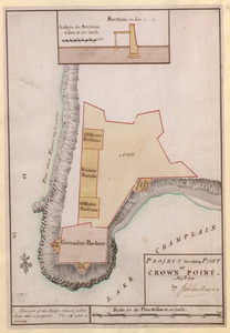
PROJECT for taking POST at CROWN POINT
325.
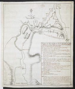
Project for the Attack of Ticonderoga, proposed to be put in executino as near as the circumstances and ground will admit of
326.
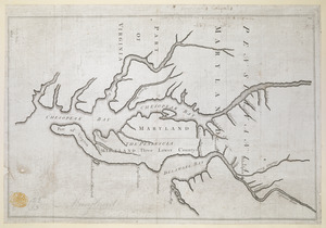
Proposed Maryland / Pennsylvania Boundary
327.
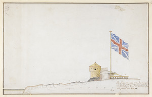
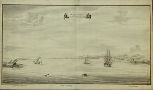
A Prospect of LOUISBOURG taken from ye NE Harbour
328.
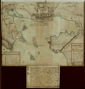
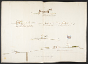
The Respective Profiles belonging to the great Iconografical Draughts of Castle Island in the Bay of Boston
329.
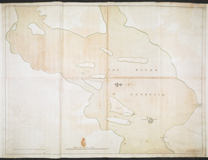
THE RIVER S.T LAURENCE
330.
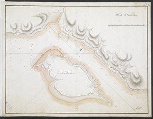
ROAD OF COUDRE
331.
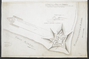
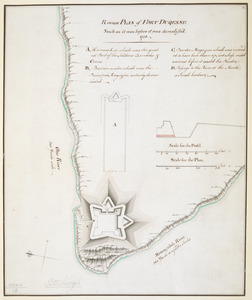
Rough PLAN of FORT DUQUESNE such as it was before it was demolish'd 1758
332.
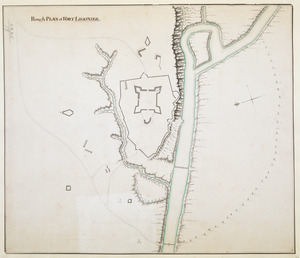
Rough PLAN of FORT LIGONIER
333.
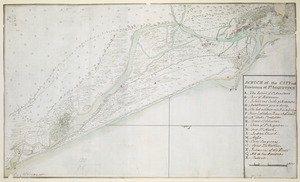
SCETCH of the CITY and Environs of S.T AUGUSTINE
334.
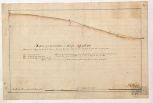
Section of the Citadel-Hill at Halifax : Showing the Progress made by the troops in leveling the same upon the line of 40 feet...
335.
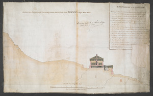
Section taken from the nearest Commanding Ground thro' the Center of the TOWER to High Water Mark
336.
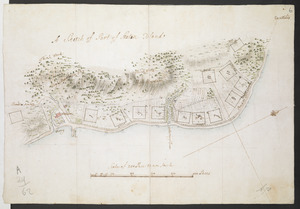
[Six sectional drawings of the Harbour of Saint John, Newfoundland]
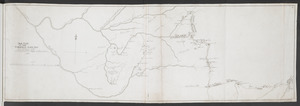
337.
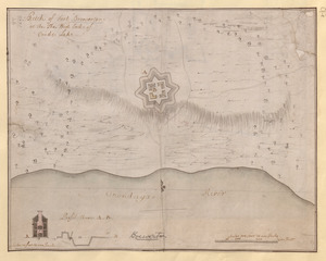
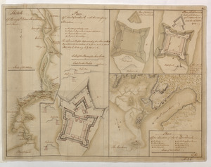
[Sketch map of an unidentified fort]
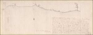
338.
[Sketch map of the St Lawrence River at River Toniata]
339.
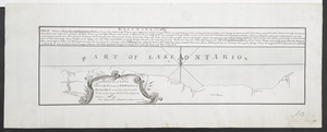
[Sketch map of the St Lawrence River from the Fort de la Présentation to Lake Ontario]
340.
Sketch of Fort Brewerton at the The West End of Onide Lake
341.
A SKETCH of FORT DU QUESNE how it was before the Enemy abandont and distryd it taken from a survey of Cap.t Gordon's
342.
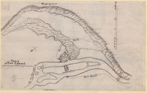
Sketch of Fort Edward and the proposed improvements
343.
SKETCH of FORTS CLINTON & MONTGOMERY Stormed 6.th October 1777 by the Troops under the Command of Sir Henry Clinton K.B. L.t...
344.
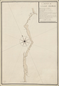
A SKETCH OF LAKE GEORGE
345.
A Sketch of Lake Ontario between Oswego and Niagara and from thence up the River to the upper end of the Carrying place
346.
A SKETCH of LAKE ONTARO between OSWEGO and NIAGARA and from thence up the River to the upper End of the Carrying Place
347.
Sketch Of Part of S.t John's Harbour and River= Plan of Fort Frederick with the Necessary Alterations= Plan of the Ramainder of...
348.
A Sketch of Part of Staten Island
349.
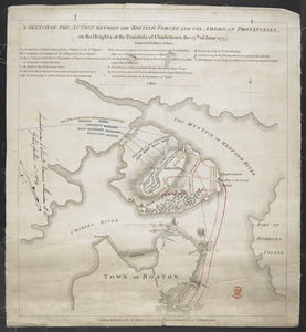
A SKETCH OF THE ACTION BETWEEN THE BRITISH FORCES AND THE AMERICAN PROVINCIALS, on the Heights of the Peninsula of Charlestown,...
350.
SKETCH OF THE CHEROKEE COUNTRY And March of the Troops Under the Command of Luet. Col. Grant to the Middle & Back Settlem:ts. 1761
‹ Prev
Next ›
1
2
3
4
5
6
7
8


![[Six sectional drawings of the Harbour of Saint John, Newfoundland]](https://bpldcassets.blob.core.windows.net/derivatives/images/commonwealth:6108vv37h/image_thumbnail_300.jpg)
![[Sketch map of an unidentified fort]](https://bpldcassets.blob.core.windows.net/derivatives/images/commonwealth:hx11z101x/image_thumbnail_300.jpg)
![[Sketch map of the St Lawrence River at River Toniata]](https://bpldcassets.blob.core.windows.net/derivatives/images/commonwealth:hx11z103g/image_thumbnail_300.jpg)
![[Sketch map of the St Lawrence River from the Fort de la Présentation to Lake Ontario]](https://bpldcassets.blob.core.windows.net/derivatives/images/commonwealth:hx11z1051/image_thumbnail_300.jpg)