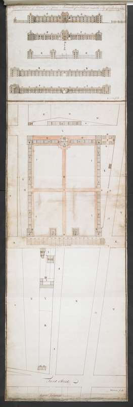
Plans & Sections of Houses for Officers & Barracks for Soldiers near the City of Philadelphia
This map is also available in American Revolutionary Geographies Online (ARGO), a collections portal especially built for material relating to the American Revolutionary War Era. Visit ARGO to learn more about this item and explore the historical geography of North America in the late eighteenth century.
Item Information
- Title:
- Plans & Sections of Houses for Officers & Barracks for Soldiers near the City of Philadelphia
- Cartographer:
- Loxley, Benjamin, 1720-1801
- Former owner:
- Royal United Services Institute for Defence and Security Studies
- Name on Item:
-
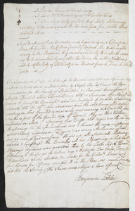
B. LOXLEY fecit.
- Date:
-
[1757]
- Format:
-
Maps/Atlases
- Location:
- British Library
- Collection (local):
-
British Library Collection
- Subjects:
-
Fortification--Pennsylvania--Philadelphia--Maps, Manuscript--Early works to 1800
Military art and science--Pennsylvania--Philadelphia--Maps, Manuscript--Early works to 1800
Philadelphia (Pa.)--Maps, Manuscript--Early works to 1800
- Places:
-
Philadelphia (county)Philadelphia
- Extent:
- 1 map on 3 sheets : joined, with separate sheet forming key, manuscript pen and ink with watercolour ; 124 x 38 cm
- Terms of Use:
-
No known copyright restrictions.
This work is licensed for use under a Creative Commons Attribution Non-Commercial Share Alike License (CC BY-NC-SA).

- Publisher:
-
[Philadelphia?] :
B. LOXLEY fecit,
- Scale:
-
Scale approximately 1:480
- Language:
-
English
- Catalog Record:
-
http://searcharchives.bl.uk/IAMS_VU2:IAMS040-001999748
- Notes:
-
Date from key, "On September the 7.th the Cellars for the Barracks were laid out"
North is oriented to the right of the map (the Delaware River is shown at the bottom)
Shows scale bar at centre, "A Scale of 40 Feet to an Inch"
Shows elevations of the barracks inset above the map
Shows signature of Loxley (stamped?) below both map and profile views
Letters on the map refer to the key on a separate sheet (signed by Loxley)
The location of the barracks is referred to by Docktor as "the area between Third Street on the west, Delaware River on the east, Green Street on the north, and Stannix Street on the South" (an area bissected today by the eastern end of Spring Garden Street?)
The Library of congress hold a facsimile (referred to by Docktor) of this map (Call Number G3824.P5 1757 .L6).
Copy at Add Ms 27,715.9. Map and profile view comprises 3 sheets joined (with scale bar pasted on). Key supplied on a separate sheet of paper. Manuscript "9" added in pencil at lower right. Laid on archival tissue. Green circular label to verso showing "19". White label to verso showing "DRAWER 36 SECTION 3". Manuscript additions to verso in pencil show "A 90" and "229". Separate key sheet (measures 34 x 21 cm) has text in brown ink (recto and verso) with the manuscript addtion of "9*" in pencil at upper right.
- Notes (date):
-
9999
This date is inferred.