Proposed Maryland / Pennsylvania Boundary
This map is also available in American Revolutionary Geographies Online (ARGO), a collections portal especially built for material relating to the American Revolutionary War Era. Visit ARGO to learn more about this item and explore the historical geography of North America in the late eighteenth century.
Item Information
- Title:
- Proposed Maryland / Pennsylvania Boundary
- Creator:
- Senex, John, -1740
- Publisher:
- Senex, John, -1740
- Former owner:
- George, III, King of Great Britain, 1738-1820
- Cartographer:
- Baltimore, Charles Calvert, Baron, 1699-1751
- Contributor:
- Penn, Thomas, 1702-1775
- Contributor:
- Penn, Richard, 1706-1771
- Contributor:
- Penn, John, 1700-1746
- Contributor:
- Visscher, Nicolaes, 1618-1679
- Printmaker:
- Hutchinson, Thomas (Engraver and draughtsman)
- Contributor:
- Paris, Ferdinand John
- Name on Item:
-
[John Senex]
- Date:
-
[1735]
- Format:
-
Maps/Atlases
- Location:
- British Library
- Collection (local):
-
British Library Collection
- Subjects:
-
Boundary disputes--Maps--Early works to 1800
Maryland--Boundaries--Pennsylvania--Maps--Early works to 1800
Pennsylvania--Boundaries--Maryland--Maps--Early works to 1800
Delaware--Maps--Early works to 1800
Chesapeake Bay (Md. and Va.)--Maps--Early works to 1800
- Places:
-
Pennsylvania
Chesapeake Bay
Maryland
Delaware
- Extent:
- 1 map : copperplate engraving ; 36 x 24 cm
- Terms of Use:
-
No known copyright restrictions.
This work is licensed for use under a Creative Commons Attribution Non-Commercial Share Alike License (CC BY-NC-SA).

- Publisher:
-
[London] :
[John Senex]
- Scale:
-
Scale not given
- Language:
-
English
- Catalog Record:
-
http://explore.bl.uk/BLVU1:LSCOP-ALL:BLL01016685861
- Notes:
-
Publication details from Morrison.
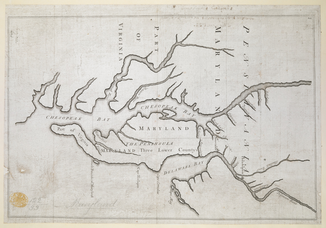
The manuscript map from which this engraved map was produced was drawn by Charles Calvert, 5th Baron Baltimore, during negotiations with the Penn family regarding the Maryland/Pennsylvania border in 1731. Negotiations were mediated by the lawyer Ferdinando John Paris - Pritchard & Taliaferro.
Reference sources refer to Ferdinand John Paris (Library of Congress Subject Headings), Ferdinando John Paris (Pritchard & Taliaferro) and John Fernando Paris (Morrison).
The manuscript map was sent to London where it was engraved by Thomas Hutchinson and published by John Senex - Pritchard & Taliaferro (from Wainwright).
Morrison lists the editions and states of the map (from Wainwright).
The first edition, first state of the map (a proof state in 1732) included a scale of distances at lower left. The proof state also shows a complete circle around Newcastle to the Delaware River and no southern boundary of Maryland is shown - Morrison.
A corrected state of the map was also issued in 1732 - Morrison. This corrected state erases the scale at lower left (although traces remain) and includes a northern boundary line for Maryland (dotted) extending to the left border of the map. Names are added and the lower part of the circle around Newcastle is now incomplete.
The corrected state of the map was re-printed and re-issued in 1735 (from the 1732 plate) with manuscript inscriptions at lower right in the hand of Ferdinand John Paris with "This is Lord Baltimore's own Plan, annext to the Articles of Agreement of 10 May 1732" - Morrison.
Morrison states that all known copies of the 1735 issue have this manuscript endorsement at lower right. Pritchard and Taliaferro claim "most" of the 1735 re-issued maps were endorsed by Paris.
This K.Top example of the map (Maps K.Top.122.33.) does not have the inscription at lower right but the verso inscription is certainly in the same hand as the example of the map illustrated in Papenfuse and Coale (thus a date of 1735 is attributed). The verso inscription in ink (by Ferdinand John Paris) of this K.Top example reads "Maryland Pensilvania &c annext to his Agreement with Mess.rs Penn in the year 1732".
The 1735 re-issue of the map with manuscript annotation was produced to accompany "True Copies of I. The Agreement between Lord Baltimore and Messieurs Penn, dated 10 May 1732. II. The Commissions given to the Commissioners to mark out the Lines between Maryland, and Pensilvania and the Three Lower Counties on Delaware. III. The Return or Report of the Commissioners on both Sides, made 24 Nov. 1733. Shewing for what Reasons the Lines were not mark’d out within the Time appointed for that Purpose". Title from the example being sold by Seth Kaller (http://www.sethkaller.com/item/72-1732-Agreement-to-the-%E2%80%98Lord-Baltimore-%E2%80%93-Penn-Dispute%E2%80%99-Including-the-Rare-Senex-Map - website viewed April 2014), although Kaller's example of the map (lacking the manuscript addition at lower right) and pamphlet were acquired separately by a prior owner.
The ESTC refers to the "Articles of agreement, &c." [London, 1733?] with the variant title "Articles of agreement made and concluded upon between the Right Honourable the Lord Proprietary of Maryland, and the Honourable the Proprietarys of Pensilvania" [London, 1733?]. ESTC lists copies held by the British Library, the John Carter Brown Library at Brown University, the John Work Garrett Library at Johns Hopkins University, and at the Library of Congress. However, the British Library online catalogue lists only the 1742 "Breviate" example (with the shelfmark - General Reference Collection C.161.d.1.).
Lord Baltimore's original manuscript map was based on Nicolaes Visscher's map of "Novi Belgii ...", both of which positioned "Cape Hinlopen" incorrectly, leading to the continuing Maryland and Pennsylvania boundary disputes that were resolved only with the Mason-Dixon line in the 1760s.
On realising his incorrect positioning of Cape Hinlopen on his original map (and the lands it cost him), Lord Baltimore petitioned King George II. The 1735 re-issue of the map with the manuscript endorsement by Paris was Paris' attempt to expose Lord Baltimore's false claims of deception - Pritchard & Taliferro.
Further re-issues of the map appeared in 1742 (60 copies re-issued by Senex for use in "Breviate") and in 1760 (apparently on vellum) - Morrison.
A second edition of the map was printed in 1733 in North America. This was a woodcut copy by Benjamin Franklin - Morrison.
Titled "Copy of Lord Baltimore's Map of Maryland, Pensilvania, &c. annexed to his agreement with Messrs. Penn in the year 1732" in the Catalogue of Maps, Prints, Drawings, etc., forming the geographical and topographical collection attached to the Library of his late Majesty King George the third, etc., London, 1829.
Previous British Library cataloguing (online) listed this map (incorrectly) as "A Map of New England ... and Pensilvania. By H. Moll, Geographer ... 1730" with a scale of English miles, 60 [=70 mm], published in "An Historical Account of the Incorporated Society for the propagation of the Gospel in foreign parts ... By David Humphreys", page 144.
- Notes (date):
-
This date is inferred.
- Notes (citation):
-
British Museum, Catalogue of Maps, Prints, Drawings, etc., forming the geographical and topographical collection attached to the Library of his late Majesty King George the third, etc., London, 1829
Morrison, Russell. On the map. An exhibit and catalogue of maps relating to Maryland and the Chesapeake Bay, figure 29
Papenfuse, Edward C. and Coale III, Jospeh M. The Maryland State Archives. Atlas of historical maps of Maryland, pages 55 to 57
Pritchard, Margaret Beck and Taliaferro, Henry G. Degrees of latitude. Mapping Colonial America, 23
Wainwright, Nicholas B. Tale of a Runaway Cape: The Penn-Baltimore Agreement of 1732 in "The Pennsylvania Magazine of History and Biography", Volume 87, Number 3, July 1963, pages 251 to 293
- Identifier:
-
k_top_122_33


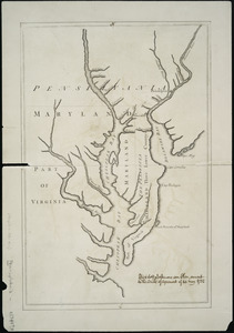
![[A map of part of Pennsylvania & Maryland intended to shew, at one view, the several places proposed for opening a communication between the waters of the Delaware & Chesopeak Bays]](https://bpldcassets.blob.core.windows.net/derivatives/images/commonwealth:z603vt12v/image_thumbnail_300.jpg)

