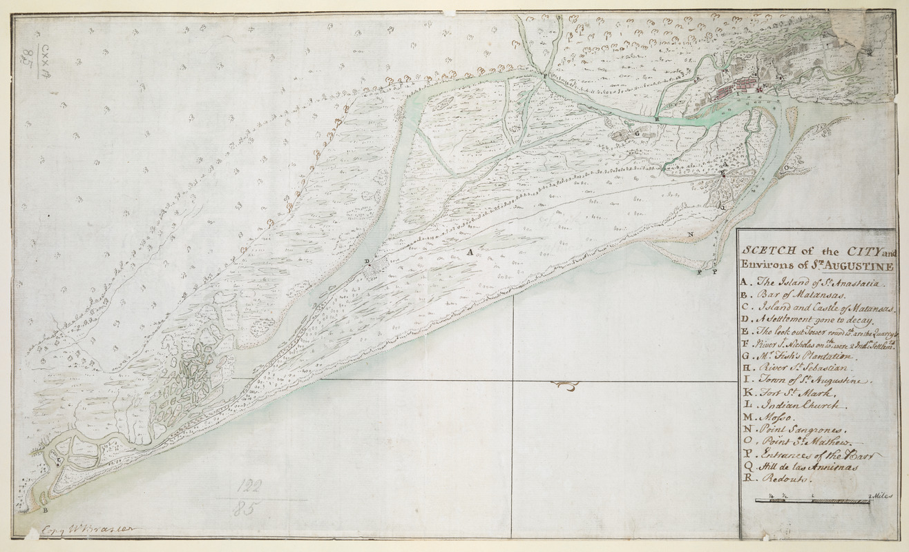
SCETCH of the CITY and Environs of S.T AUGUSTINE
This map is also available in American Revolutionary Geographies Online (ARGO), a collections portal especially built for material relating to the American Revolutionary War Era. Visit ARGO to learn more about this item and explore the historical geography of North America in the late eighteenth century.
Item Information
- Title:
- SCETCH of the CITY and Environs of S.T AUGUSTINE
- Cartographer:
- Brasier, William
- Former owner:
- George, III, King of Great Britain, 1738-1820
- Donor:
- George, IV, King of Great Britain, 1762-1830
- Name on Item:
-
Copy W. Brasier.
- Date:
-
1763
- Format:
-
Maps/Atlases
Manuscripts
- Location:
- British Library
- Collection (local):
-
British Library Collection
- Subjects:
-
Saint Augustine (Fla.)--Maps, Manuscript--Early works to 1800
- Places:
-
Saint Johns (county)Saint Augustine
- Extent:
- 1 map : manuscript pen and ink with watercolour ; 24 x 41 cm
- Terms of Use:
-
No known copyright restrictions.
This work is licensed for use under a Creative Commons Attribution Non-Commercial Share Alike License (CC BY-NC-SA).

- Scale:
-
Scale approximately 1:63,360
- Language:
-
English
- Catalog Record:
-
http://explore.bl.uk/BLVU1:LSCOP-ALL:BLL01004987579
- Notes:
-
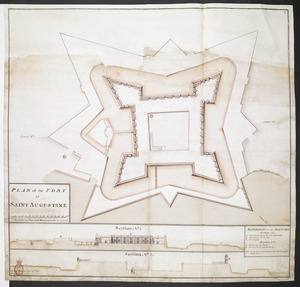
Production details from The National Archive example of Brasier's "Scetch" of Saint Augustine.
Relief shown pictorially.
North is oriented to the right of the map, indicated by a compass arrow in the Atlantic Ocean.
Signature at lower left.
Title and lettered key (A-R) at lower right.
Includes a scale of miles at lower right.
Shows forts.
Compare "Scetch of the City and Environs of St. Augustine. MS. 1 mile to 1 inch" held by The National Archives, Kew (CO 700/FLORIDA23).
Compare 'Plan of the fort at Saint Augustine', surveyed by Phillip Pitman 'Lieut. 15th Regt.', drawn by William Brasier; circa 1760 . 1:360 approx. 'Scale for the plan and sections 30 feet to an inch'. Scale bar of 140 feet (= 5 inches). Amherst no. C 21. R.U.S.I. no. A 30.22. 625 x 655 mm (Add MS 57704 : 18th century).
Titled "A drawn Sketch of the City and Environs of St. Augustine, copiedby W. Brasier" in the Catalogue of Maps, Prints, Drawings, etc., forming the geographical and topographical collection attached to the Library of his late Majesty King George the third, etc., London, 1829.
Titled 'A colored "sketch [plan] of the city and environs of St. Augustine;" drawn by W. Brasier, on a scale of 1 mile to an inch: 1 f. 4 in. x 9 1/2 in.' in the Catalogue of the manuscript maps, charts, and plans, and of the topographical drawings in the British Museum.

![[Map of the coast of Florida from Fort William to Musketae River] [north sheet]](https://bpldcassets.blob.core.windows.net/derivatives/images/commonwealth:hx11z4742/image_thumbnail_300.jpg)
![[Map of the coast of Florida from Fort William to Musketae River] [south sheet]](https://bpldcassets.blob.core.windows.net/derivatives/images/commonwealth:hx11z476m/image_thumbnail_300.jpg)