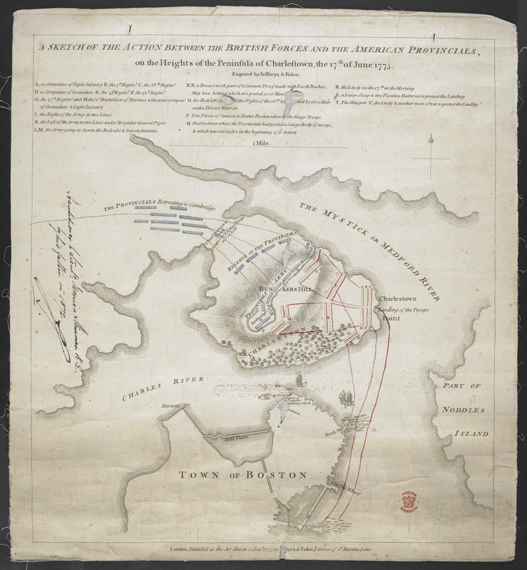
A SKETCH OF THE ACTION BETWEEN THE BRITISH FORCES AND THE AMERICAN PROVINCIALS, on the Heights of the Peninsula of Charlestown, the 17th June 1775
This map is also available in American Revolutionary Geographies Online (ARGO), a collections portal especially built for material relating to the American Revolutionary War Era. Visit ARGO to learn more about this item and explore the historical geography of North America in the late eighteenth century.
Item Information
- Title:
- A SKETCH OF THE ACTION BETWEEN THE BRITISH FORCES AND THE AMERICAN PROVINCIALS, on the Heights of the Peninsula of Charlestown, the 17th June 1775
- Cartographer:
- Jefferys, Thomas, -1771
- Publisher:
- Faden, William, ????
- Former owner:
- Skinner, William, 1700-1780
- Former owner:
- Skinner, Monier
- Name on Item:
-
Engraved by Jefferys & Faden.
- Date:
-
[1775]
- Format:
-
Maps/Atlases
- Location:
- British Library
- Collection (local):
-
British Library Collection
- Subjects:
-
Bunker Hill, Battle of, Boston, Mass., 1775--Maps, Manuscript--Early works to 1800
Military art and science--Massachusetts--Boston--Maps, Manuscript--Early works to 1800
Boston (Mass.)--Maps, Manuscript--Early works to 1800
United States--History--Revolution, 1775-1783--Maps, Manuscript--Early works to 1800
- Places:
-
Suffolk (county)BostonBunker Hill
- Extent:
- 1 map : copperplate engraving, hand colour ; 34 x 31 cm
- Terms of Use:
-
No known copyright restrictions.
This work is licensed for use under a Creative Commons Attribution Non-Commercial Share Alike License (CC BY-NC-SA).

- Publisher:
-
London :
Published as the Act directs 1 Aug.t 1775 Jefferys & Faden ye Corner of St Martins Lane,
- Scale:
-
Scale approximately 1:13,700
- Language:
-
English
- Catalog Record:
-
http://searcharchives.bl.uk/IAMS_VU2:IAMS040-002027390
- Notes:
-
Relief shown by shading and by hachuring.
Shows title at upper centre with lettered key (A-T) and scale bar (of 1 Mile).
Shows position and movements of troops.
Shows imprint in lower margin.
Copy at Add Ms 33,231.NN.1. A roll - laid on linen. Manuscript annotation at centre left in black ink, "Handed over to Lieut. Monier Skinner R. Eng.r by his father in 1872" and initialled (by Monier Skinner?). Red stamp of British Museum at lower right. Pressmark stamped to verso and repeated in pencil.
- Notes (date):
-
9999
This date is inferred.

![[Map of Narragansett Bay]](https://bpldcassets.blob.core.windows.net/derivatives/images/commonwealth:hx11z2791/image_thumbnail_300.jpg)