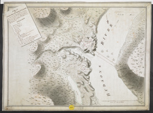
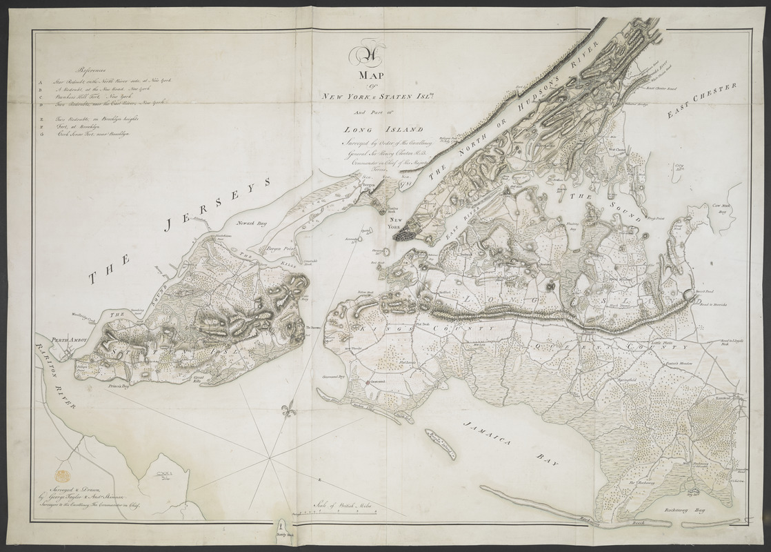
A MAP of NEW YORK, & STATEN ISLDS; And part of LONG ISLAND : Surveyed by Order of His Excellency General Sir Henry Clinton K.B. Commander in Chief of His Majesty's Forces &ca. &ca. &ca. 1781
This map is also available in American Revolutionary Geographies Online (ARGO), a collections portal especially built for material relating to the American Revolutionary War Era. Visit ARGO to learn more about this item and explore the historical geography of North America in the late eighteenth century.
Item Information
- Title:
- A MAP of NEW YORK, & STATEN ISLDS; And part of LONG ISLAND : Surveyed by Order of His Excellency General Sir Henry Clinton K.B. Commander in Chief of His Majesty's Forces &ca. &ca. &ca. 1781
- Former owner:
- George, III, King of Great Britain, 1738-1820
- Donor:
- George, IV, King of Great Britain, 1762-1830
- Contributor:
- Clinton, Henry, Sir, 1738?-1795
- Cartographer:
- Taylor, George, (Geographer), active 1778
- Cartographer:
- Skinner, Andrew, (Geographer)
- Name on Item:
-
Surveyed & Drawn by George Taylor & And:w Skinner. Surveyors to His Excellency the Commander in Chief.
- Date:
-
1781
- Format:
-
Maps/Atlases
Manuscripts
- Location:
- British Library
- Collection (local):
-
British Library Collection
- Subjects:
-
Fortification--New York (State)--Maps, Manuscript--Early works to 1800
New York (N.Y.)--Maps, Manuscript--Early works to 1800
Staten Island (New York, N.Y.)--Maps, Manuscript--Early works to 1800
United States--History--Revolution, 1775-1783--Maps, Manuscript--Early works to 1800
- Places:
-
Richmond (county)Staten Island (island)
- Extent:
- 1 map on 2 sheets : joined and laid on linen, manuscript pen and ink with watercolour ; 97 x 66 cm
- Terms of Use:
-
No known copyright restrictions.
This work is licensed for use under a Creative Commons Attribution Non-Commercial Share Alike License (CC BY-NC-SA).

- Scale:
-
Scale 1:63,360
- Language:
-
English
- Catalog Record:
-
http://explore.bl.uk/BLVU1:LSCOP-ALL:BLL01004987665
- Notes:
-
Relief shown by shading.
Shows roads.
Shows forts.
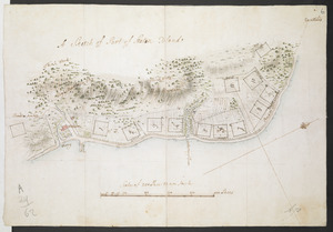
With references at upper left (A to G) listing the forts to include "Star redoubt, on the North River side, at New york", "A Redoubt, at the New Road, New York", "Bunker's Hill Fort, New York", "Two Redouts, near the East River, New York", "Two Redoubts, at Brooklyn heights", "Fort, at Brooklyn" and "Corkscrew Fort, near Brooklyn".
Another example of the map is held by The National Archives at Kew - WO 78/1843.
An incomplete (Guthorn) example of the map is held by the Library of Congress - G3804.N4A1 1782 .P5 Vault.
Titled "A drawn Map of New York and Staten Islands and part of Long Island, surveyed by order of H. E. General Sir Henry Clinton, K. B. by G. Taylor and A. Skinner, 1781. Two sheets" in the Catalogue of Maps, Prints, Drawings, etc., forming the geographical and topographical collection attached to the Library of his late Majesty King George the third, etc., London, 1829.
Titled 'A colored "map of New York and Staten Islands, and part of Long Island; surveyed by order of H.E. General Sir Henry Clinton, K.B., commander-in-chief of His Majesty's forces, 1781;' drawn by George Taylor and Andrew Skinner, on a scale of one mile to an inch: 3 f. 2 in. x 2 f. 2 in." in the Catalogue of the manuscript maps, charts, and plans, and of the topographical drawings in the British Museum.
The map extends to Bergen and Fordham Heights in the north and extends southwards to show all of Staten Island and to Jamaica Bay.

![[New York Island and the Narrows. 1781]](https://bpldcassets.blob.core.windows.net/derivatives/images/commonwealth:hx11z295d/image_thumbnail_300.jpg)