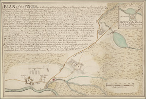
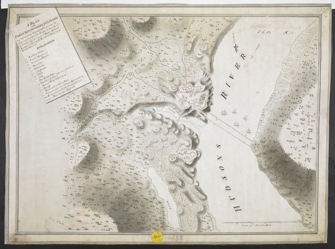
A PLAN of the FORTS MONTGOMERY & CLINTON as taken by his Majesty's Forces under the Command of Gen:l Sir Henry clinton the 6.th of October 1777
This map is also available in American Revolutionary Geographies Online (ARGO), a collections portal especially built for material relating to the American Revolutionary War Era. Visit ARGO to learn more about this item and explore the historical geography of North America in the late eighteenth century.
Item Information
- Title:
- A PLAN of the FORTS MONTGOMERY & CLINTON as taken by his Majesty's Forces under the Command of Gen:l Sir Henry clinton the 6.th of October 1777
- Surveyor:
- Holland, Samuel, 1728-1801
- Associated name:
- Clinton, Henry, Sir, 1738?-1795
- Former owner:
- Frazer, Sir Augustus Simon, 1776-1835
- Former owner:
- Royal United Services Institute for Defence and Security Studies
- Name on Item:
-
Surveyed by Major Holland Surveyor Gen:l of the Northern District of North America.
- Date:
-
[1777]
- Format:
-
Maps/Atlases
- Location:
- British Library
- Collection (local):
-
British Library Collection
- Subjects:
-
Fortification--New York (State)--Maps, Manuscript--Early works to 1800
Military art and science--New York (State)--Maps, Manuscript--Early works to 1800
Fort Montgomery State Historic Site (Highlands, N.Y.)--Maps, Manuscript--Early works to 1800
Fort Clinton (Rockland County, N.Y.)--Maps, Manuscript--Early works to 1800
United States--History--Revolution, 1775-1783--Maps, Manuscript--Early works to 1800
- Places:
-
Orange (county)Fort Montgomery
Fort Clinton
- Extent:
- 1 map : manuscript pen and ink with watercolour ; 38 x 53 cm
- Terms of Use:
-
No known copyright restrictions.
This work is licensed for use under a Creative Commons Attribution Non-Commercial Share Alike License (CC BY-NC-SA).

- Publisher:
-
[Place of production not identified] :
Surveyed by Major Holland Surveyor Gen:l of the Northern District of North America,
- Scale:
-
Scale approximately 1:6,000
- Language:
-
English
- Catalog Record:
-
http://searcharchives.bl.uk/IAMS_VU2:IAMS040-001999748
- Notes:
-
Relief shown by shading
Shows title at upper left including a lettered key (a-o)
Map contained within an ink, lined border (forming a frame or mount effect)
Shows scale bar at lower right, "Scale of Statute Miles"
Shows chains and cables across the Hudson
Compare the similar manuscript map: "A plan of the Forts Montgomery & Clinton as taken by His Majesty's forces under the command of Genl. Sr. Henry Clinton the 6th. of Octr. 1777" held by the Library of Congress (Call Number G3804.F5865 1777 .H6)
Compare a similar map of forts Montgomery and Clinton, number 14.029a (fiche 497/1), in the King's Military Collection at the Royal Library, Windsor?
Copy at Add Ms 27,715.7. Manuscript "7" added in pencil at upper right and "168" (crossed through) at lower centre. Shows a yellow circular label "MC" at lower centre. Manuscript addition in ink at upper right shows "Presented Colonel Augustus Frazer K.C.B. R.A.". Laid on archival tissue. Green circular label to verso showing "23". White label to verso showing "DRAWER 30 SECTION 1". Blue label to verso showing "A 30/49". Additional labels show "190". Manuscript annotations to verso in ink show "Plan of Forts Montgomery & Clinton".
- Notes (date):
-
9999
This date is inferred.