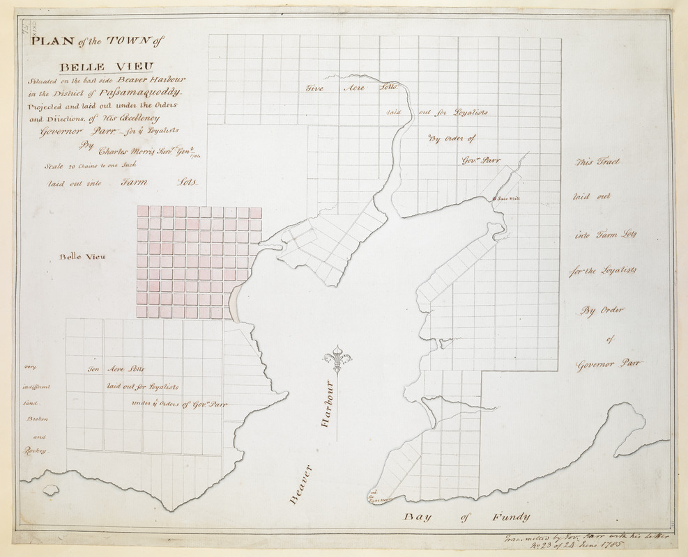
PLAN of the TOWN of BELLE VIEU situated on the East side Beaver Harbour in the District of Passamaquoddy
This map is also available in American Revolutionary Geographies Online (ARGO), a collections portal especially built for material relating to the American Revolutionary War Era. Visit ARGO to learn more about this item and explore the historical geography of North America in the late eighteenth century.
Item Information
- Title:
- PLAN of the TOWN of BELLE VIEU situated on the East side Beaver Harbour in the District of Passamaquoddy
- Description:
-
A manuscript map of the settlement of Belle Vieu (present-day Beaver Harbour in New Brunswick) showing the land available to Loyalists who had resettled in British North America as an act of loyalty to George III after the British defeat in the American Revolutionary War. Ordered by Governor General of Nova Scotia, John Parr, and surveyed by Charles Morris.
- Surveyor:
- Morris, Charles, (Surveyor)
- Former owner:
- George, III, King of Great Britain, 1738-1820
- Donor:
- George, IV, King of Great Britain, 1762-1830
- Contributor:
- Parr, John, 1725-1791
- Name on Item:
-
Projected and laid out under the Orders and Diiections. of His Excellency Governor Parr for ye Loyalists By Charles Morris Survr. Genl. 1784. scale 20 chains to one Inch laid out into Farm Lots.
- Date:
-
1785
- Format:
-
Maps/Atlases
Manuscripts
- Location:
- British Library
- Collection (local):
-
British Library Collection
- Subjects:
-
United Empire loyalists--Maps, Manuscript--Early works to 1800
New Brunswick--Maps, Manuscript--Early works to 1800
- Places:
-
CanadaProvince of New Brunswick (province)
- Extent:
- 1 map : manuscript pen and ink with watercolour ; 35 x 44 cm
- Terms of Use:
-
No known copyright restrictions.
This work is licensed for use under a Creative Commons Attribution Non-Commercial Share Alike License (CC BY-NC-SA).

- Scale:
-
Scale approximately 1:15,840
- Language:
-
English
- Catalog Record:
-
http://explore.bl.uk/BLVU1:LSCOP-ALL:BLL01004987882
- Notes:
-
A manuscript note in ink just outside the neatline at lower right reads "Transmitted by Gov. Parr with his Letter No.23 of 24 June 1785".
The scale of "20 chains to one Inch laid out into Farm Lots" is given as text - running on from the map's title at upper left.
Textual notes on the map indicate farm, five and ten acre lots laid out for the Loyalists (those who left the United States and resettled in British North America as an act of loyalty to George III after the British defeat in the American Revolutionary War). Additional land is described as "very indifferent Land - Broken and Rockey".
The settlement of Belle Vieu was destroyed by fire in 1790. The village of Beaver Harbour, New Brunswick now occupies its approximate location.
The saw mill and a plot reserved for the lighthouse are indicated on the map.
A decorative directional arrow orients north to the top of the page.
Titled 'Plan of the town of Belle Vieu, situated on the East side Beaver Harbour, in the district of Passamaquoddy, projected and laid out under the directions of H.E. Governor Parr, for the loyalists, by Charles Morris, surveyor-general, 1784; drawn on a scale of 20 chains to an inch : 1 f. 5 in. x 1 f. 1 in. transmitted by Governor Parr, in June, 1785' in Catalogue of the manuscript maps, charts, and plans, and of the topographical drawings in the British Museum.
Titled 'A drawn Plan of the Town of Belle Vieu on the East side of Beaver Harbour, in the District of Passamaquoddy, projected and laid out by of H.E. Governor Parr, for the Loyalists : by Charles Morris, Surveyor General, 1784.' in the Catalogue of Maps, Prints, Drawings, etc., forming the geographical and topographical collection attached to the Library of his late Majesty King George the third, etc., London, 1829.


 IIIF Manifest