Toggle navigation
LMEC Home
Exhibitions
Georeferencing
Tools for Teachers
Collections
My Favorites
Sign Up / Log In
Search
Search the map portal
Map Collection
Map Collection
Map Sets
Search
Search
Search for
Search In
All Fields
Creator
Title
Subject
Place
Search All Digital Collections
Advanced Search
494 Results
My Search
Start Over
More Like
commonwealth:z603vv06x
Remove constraint More Like: commonwealth:z603vv06x
Filter your Search
Place
North and Central America
263
United States
190
North America
176
South America
49
Canada
43
New York
34
Suffolk (county)
31
Boston
29
more
Place
»
Topic
North America--Maps--Early works to 1800
180
South America--Maps--Early works to 1800
46
United States--Maps--Early works to 1800
20
Boston (Mass.)--History--Revolution, 1775-1783--Maps--Early works to 1800
16
Great Britain--Colonies--America--Maps--Early works to 1800
15
Canada--Maps--Early works to 1800
14
New England--Maps--Early works to 1800
11
United States--History--French and Indian War, 1754-1763--Maps--Early works to 1800
11
more
Topic
»
Date
Date range begin
–
Date range end
Current results range from
1528
to
1850
View distribution
Creator
Jefferys, Thomas, -1771
40
Faden, William, 1749-1836
34
Sayer, Robert, 1725-1794
29
Le Rouge, Georges-Louis
24
Des Barres, Joseph F. W. (Joseph Frederick Wallet), 1722-1824
21
Moll, Herman, d. 1732
18
Mitchell, John, 1711-1768
14
Korn, Christoph Heinrich, 1726-1783
11
more
Creator
»
Format
Maps/Atlases
451
Prints
32
Manuscripts
25
Drawings/Illustrations
9
Books
2
Georeferenced
Yes
17
No
477
Collection
American Revolutionary War-Era Maps
392
Richard H. Brown Revolutionary War Map Collection at Mount Vernon
293
Norman B. Leventhal Map Center Collection
150
New York Public Library Collection
32
Mapping Boston Collection
9
Sidney R. Knafel Map Collection at Phillips Academy
8
Boston and New England Maps
6
Maritime Charts and Atlases
4
more
Collection
»
Available to use
Creative Commons license
339
No known restrictions
144
Search Constraints
Sort by relevance
relevance
title
date (asc)
date (desc)
Number of results to display per page
50 per page
10
per page
20
per page
50
per page
100
per page
View results as:
grid view
map view
Search Results
151.
Map of the northern, or, New England states of America, comprehending Vermont, New Hampshire, District of Main, Massachusetts,...
152.
Map of the northern, or, New England states of America, comprehending Vermont, New Hampshire, District of Main, Massachusetts,...
153.
Mappa geographica Americae Septentrionalis : ad emendatiora exemplaria adhuc edita jussu Acad. reg. scient. et eleg. litt....
154.
Mexicum in hac forma in lucem
155.
New & accurate map of North America : with the new discovered islands on the north east coast of Asia
156.
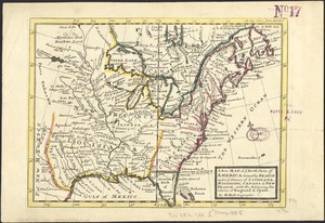
A new & accurate map of North America : drawn from the most authentic modern maps and charts
157.
A new and accurate map of North America : laid down according to the latest, and most approved observations and discoveries
158.
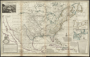
A new and accurate map of North America
159.
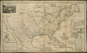
A new and accurate map of North America : laid down according to the latest, and most approved observations and discoveries
160.
A new and accurate map of the English empire in North America : representing their rightful claim as confirm'd by charters, and...
161.
A new and accurate map of the English empire in North America : representing their rightful claim as confirm'd by charters, and...
162.
A new and correct map of North America, with the West India Islands : divided according to the last Treaty of Peace, concluded...
163.
A new and correct map of North America with the West India Islands : divided according to the last treaty of peace, concluded...
164.
A new and correct map of North America, with the West India islands, divided according to the preliminary articles of peace,...
165.
A New and correct map of the British colonies in North America comprehending eastern Canada with the province of Quebec, New...
166.
A new and exact map of the dominions of the King of Great Britain on ye continent of North America : containing Newfoundland,...
167.
A new and exact map of the dominions of the King of Great Britain on ye continent of North America : containing Newfoundland,...
168.
A new map of North America : with the British, French, Spanish, Dutch & Danish dominions on that great continent, and the West...
169.
A new map of North America
170.
A new map of North America from the latest discoveries
171.
A new map of North America from the latest discoveries
172.
A new map of North America shewing its principal divisions, chief cities, townes, rivers, mountains &c
173.
A New map of North America with the West India Islands : divided according to the preliminary articles of peace, signed at...
174.
A New map of North America with the West India Islands : divided according to the preliminary articles of peace, signed at...
175.
A new map of the English empire in America viz. Virginia, Maryland, Carolina, Pennsylvania, New York, New Iarsey, New England,...
176.
A new map of the most considerable plantations of the English in America
177.
A new map of the most considerable plantations of the English in America
178.
A new map of the north parts of America claimed by France under ye names of Louisiana, Mississipi, Canada, and New France with...
179.
A new map of the north parts of America claimed by France under ye names of Louisiana, Mississipi, Canada, and New France with...
180.
A new map of the north parts of America claimed by France under ye names of Louisiana, Mississipi, Canada, and New France with...
181.
A new map of the United States of North America with the British dominions on that continent &c
182.
A new map of ye north parts of America claimed by France under ye names of Louisiana, Mississipi, Canada & new France with the...
183.
Nieuwe kaart van de Grootbrittannische volkplantingen in Noord America : waar in tevens de Fransche bezittingen en de Landen,...
184.
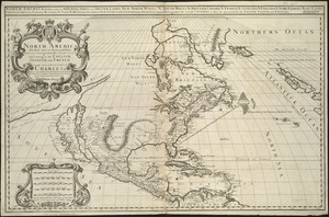
North America
185.
North America
186.
North America
187.
North America : from the French of Mr. d'Anville, improved with the back settlements of Virginia and course of Ohio,...
188.
North America
189.
North America : corrected from the observation communicated to the Royal Society at London and the Royal Academy at Paris
190.
North America
191.
North America
192.
North America : performed under the patronage of Louis Duke of Orleans, First Prince of the Blood
193.
North America, agreeable to the most approved maps and charts
194.
North America, as divided amongst the European powers
195.
North America divided into its III principall parts : 1st English part viz. English Empire containing ye Articklands near...
196.
North America, divided into its principall parts where are distinguished the severall states which belong to the English,...
197.
North America, drawn from the best authorities
198.
North America drawn from the latest and best authorities
199.
North America from the French of Mr. D'Anville, improved with the back settlements of Virginia and course of Ohio, illustrated...
200.
The north part of America : conteyning Newfoundland, new England, Virginia, Florida, new Spaine, and Noua Francia wth ye rich...
‹ Prev
Next ›
1
2
3
4
5
6
7
8
9
10