A new map of the north parts of America claimed by France under ye names of Louisiana, Mississipi, Canada, and New France with ye adjoining territories of England and Spain
Item Information
- Title:
- A new map of the north parts of America claimed by France under ye names of Louisiana, Mississipi, Canada, and New France with ye adjoining territories of England and Spain
- Description:
-
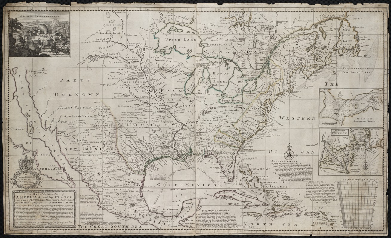
In 1720, London geographer and mapmaker, Herman Moll, published this map focusing on France's North American possessions. In a message below the title, he warned his British audience of French encroachment on neighboring English interests in the region and urged them to preserve old friendships with the Iroquois and Cherokees. The depiction of the Southeast was based on recent English surveys, particularly those of Richard Berresford and Capt. Thomas Naime. However, the Southwest, where California is depicted as island, was based on outdated information that was mistakenly accepted by European mapmakers from the mid-17th century until the early 18th century.
- Creator:
- Moll, Herman, d. 1732
- Name on Item:
-
laid down according to the newest and most exact observations by H. Moll, geographer, 1720.
- Date:
-
[1720]
- Format:
-
Maps/Atlases
- Location:
- Private Collection
- Collection (local):
-
Mapping Boston Collection
- Subjects:
-
North America--Maps--Early works to 1800
- Places:
-
North America (area)
- Extent:
- 1 map : hand col. ; 59 x 100 cm.
- Terms of Use:
-
No known copyright restrictions.
This work is licensed for use under a Creative Commons Attribution Non-Commercial Share Alike License (CC BY-NC-SA).

- Publisher:
-
[London] :
Sold by H. Moll ... sold by Tho. Bowles ... [sold by] John King ... and John Bowles
- Scale:
-
Scale [ca. 1:7,500,000] ;
- Language:
-
English
- Notes:
-
Relief shown pictorially.
Depths shown by soundings.
Includes notes and ill. of "The Indian Fort Sasquesahanok."
Insets: The harbour of Annapolis Royal -- A map of ye mouth of Mississipi [i.e. Mississippi] and Mobile Rivers & c.
- Notes (date):
-
This date is inferred.
- Identifier:
-
06_01_001163
- Barcode:
-
39999052508015


