Carte tres curieuse de la Mer du Sud, contenant des remarques nouvelles et tres utiles non seulement sur les ports et iles de cette mer : mais aussy sur les principaux pays de l'Amerique tant Septentrionale que Meridionale, avec les noms & la route des voyageurs par qui la decouverte en a été faite
Item Information
- Title:
- Carte tres curieuse de la Mer du Sud, contenant des remarques nouvelles et tres utiles non seulement sur les ports et iles de cette mer : mais aussy sur les principaux pays de l'Amerique tant Septentrionale que Meridionale, avec les noms & la route des voyageurs par qui la decouverte en a été faite
- Description:
-
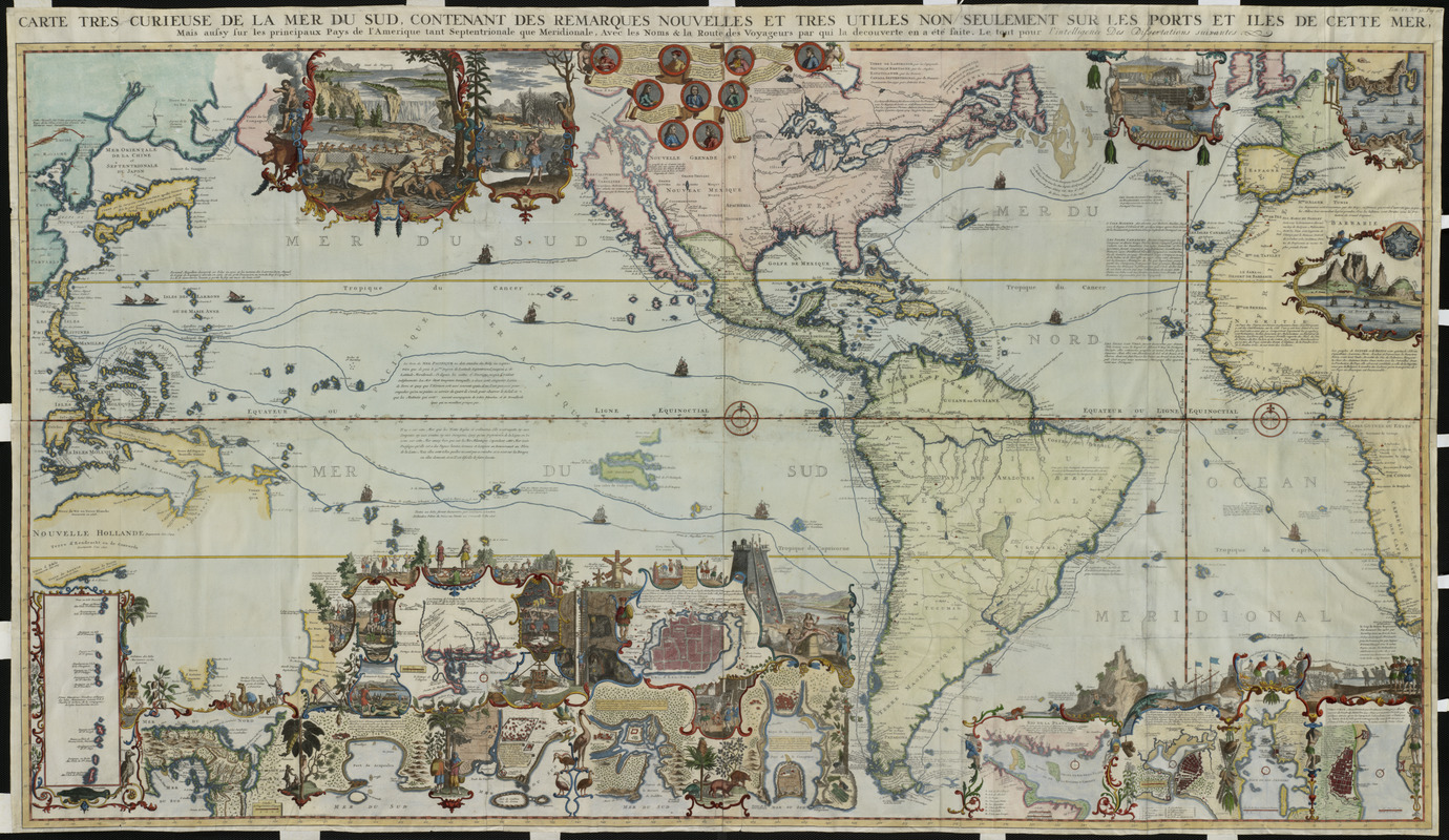
Richly decorated in the tradition of Dutch cartography, this map extends from eastern Asia to western Europe but focuses on the Pacific Ocean and the Americas. It is attributed to Henri Abraham Chatelain, a Huguenot pastor of Parisian origins who lived successively in London, The Hague, and then Amsterdam. This map was included in the seven-volume work entitled Atlas Historique, published between 1705 and 1720. This encyclopedic work was devoted to the history and genealogy of the continents, discussing such topics as geography, cosmography, topography, heraldry, and ethnography. Although the atlas was published anonymously, it was apparently compiled by Chatelain or his family, and the text was contributed by Nicolas Gueudeville, a French geographer. Appearing in the sixth volume which was devoted to the Americas, this map was a celebration of the age of discovery and the character of the New World. Reflecting the encyclopedic style of the atlas, this information-rich map included more than 35 insets and vignettes. Nine medallions at the top center portrayed important explorers including Columbus, Vespucci, Magellan, Drake, and Dampier, while the tracks of their voyages were marked on the map. The marginal vignettes range from narrative scenes depicting colonial economies based on beaver, cod, and sugar to geographic insets providing large-scale maps of significant locations, such as the Mississippi delta, Niagara Falls, the Cape of Good Hope, as well as numerous cities and towns. Although California was depicted as an island on this map, there was a notation indicating that some Europeans believed it was attached to the mainland. Consequently, this was one of the first European maps to question the myth of California as an island as depicted on many Dutch and English maps since the 1630s.
- Creator:
- Chatelain, Henri Abraham
- Date:
-
[1719]
- Format:
-
Maps/Atlases
- Location:
- Private Collection
- Collection (local):
-
Mapping Boston Collection
- Subjects:
-
North America--Maps--Early works to 1800
South America--Maps--Early works to 1800
- Places:
-
South America
South America
- Extent:
- 1 map : col. ; 82 x 143 cm.
- Terms of Use:
-
No known copyright restrictions.
This work is licensed for use under a Creative Commons Attribution Non-Commercial Share Alike License (CC BY-NC-SA).

- Publisher:
-
Amsterdam :
[s.n.]
- Scale:
-
Scale [ca. 1:20,000,000]
- Language:
-
French
- Notes:
-
Shows sailing routes of explorers.
Relief shown pictorially.
Prime meridian: L'Isle de Fer.
Includes portraits of explorers, illustrations of indigenous peoples, wildlife, flora, historical notes, and ecclesiastical plot ownerships in Havana and Veracruz.
In upper right margin: Tom: VI. No. 30. Pag 117.
Appears in Chatelain's Atlas Historique. Amsterdam. 1705-1720.
- Notes (date):
-
This date is inferred.
- Notes (exhibitions):
-
Exhibited: "Journeys of the Imagination" organized by the Norman B. Leventhal Map Center at the Boston Public Library, 2006.
Exhibited: "Unconventional Maps: Exploring the Stories of Cartographic Curiosities" organized by the Norman B. Leventhal Map Center at the Boston Public Library, 2011-2012.
- Identifier:
-
06_01_000091
- Barcode:
-
39999052509443


