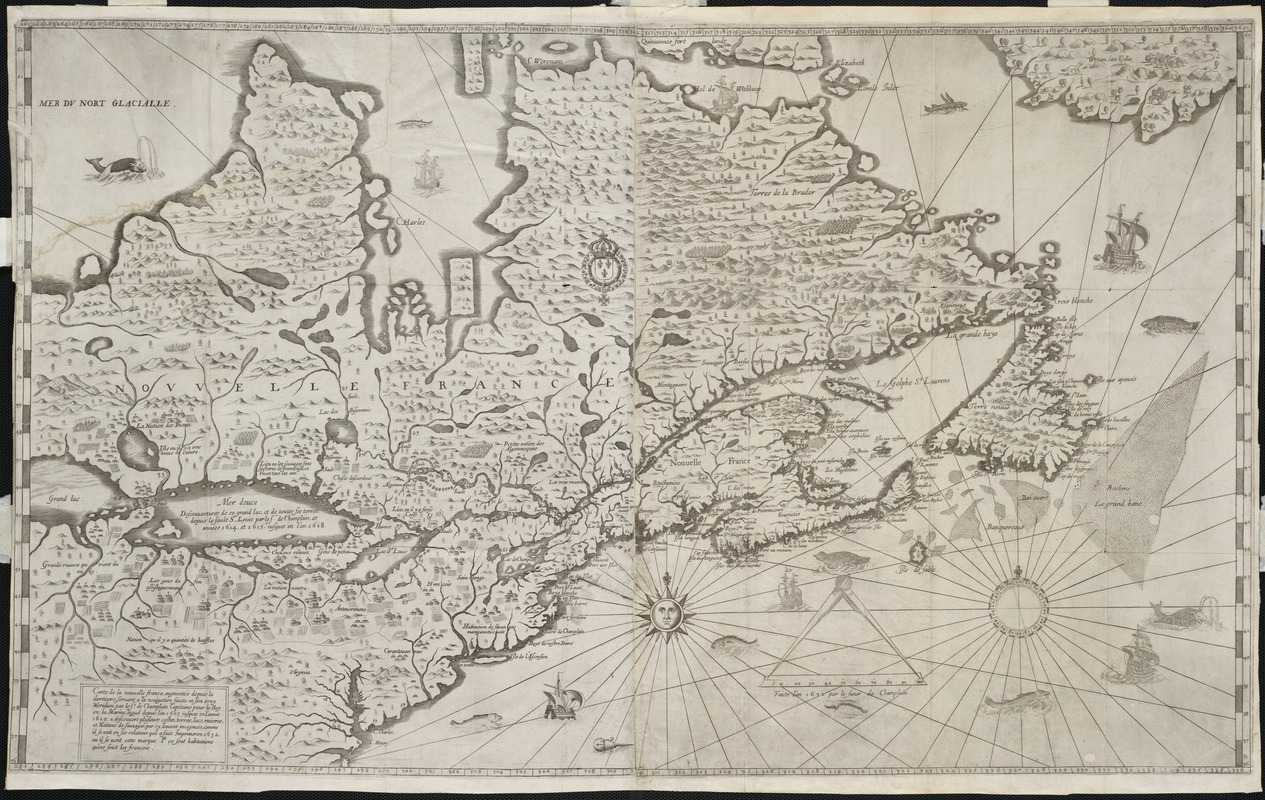
Carte de la Nouuelle France, augmentée depuis la derniere, seruant a la navigation faicte en son vray Meridien
Item Information
- Title:
- Carte de la Nouuelle France, augmentée depuis la derniere, seruant a la navigation faicte en son vray Meridien
- Description:
-
France's territorial claims in North America, which initially focused on the St. Lawrence River Valley and the Great Lakes, can be traced to Samuel de Champlain's explorations and trading activities in that region from 1603 to 1629. This rare map, the last of several prepared by Champlain, accompanied his most complete publication describing his explorations in New France (Canada) up to 1629 when he surrendered to stronger British forces. While French interests in colonizing North America were not as well supported as British efforts to the south in the Chesapeake and New England regions, Champlain was successful in establishing a small settlement at Quebec. This map is the first to depict the existence of the entire Great Lakes network -- Lac St. Louis (Lake Ontario), a rudimentary lake north of "La nation neutre" (Lake Erie), Mer douce (Lake Huron), Grand Lac (Lake Superior), and an unnamed lake to the northeast (Lake Michigan). Champlain also recorded the names and locations of numerous Native American tribes, many of whom became France's allies and trading partners in the lucrative fur trade that developed in the 17th and 18th centuries.
- Creator:
- Champlain, Samuel de, 1574-1635
- Name on Item:
-
par le Sr. de Champlain pour le Roy en la marine ... faict imprimer en 1632
- Date:
-
1632
- Format:
-
Maps/Atlases
- Location:
- Private Collection
- Collection (local):
-
Mapping Boston Collection
- Subjects:
-
Indians of North America--Canada, Eastern--Maps--Early works to 1800
New France--Maps--Early works to 1800
North America--Maps--Early works to 1800
Great Lakes Region (North America)--Maps--Early works to 1800
- Places:
-
New France (former administrative division)
Great Lakes Region (area)
- Extent:
- 1 map ; 87 x 57 cm.
- Terms of Use:
-
No known copyright restrictions.
This work is licensed for use under a Creative Commons Attribution Non-Commercial Share Alike License (CC BY-NC-SA).

- Publisher:
-
Paris :
[s.n.]
- Scale:
-
Scale not given
- Language:
-
French
- Notes:
-
Appears in Champlain's Voyages de la Nouuelle France occidentale... Paris. 1632.
France's territorial claims in North America, which initially focused on the St. Lawrence River Valley and the Great Lakes, can be traced to Samuel de Champlain's explorations and trading activities in that region from 1603 to 1629. This rare map, the last of several prepared by Champlain, accompanied his most complete publication describing his explorations in New France (Canada) up to 1629 when he surrendered to stronger British forces. While French interests in colonizing North America were not as well supported as British efforts to the south in the Chesapeake and New England regions, Champlain was successful in establishing a small settlement at Quebec. This map is the first to depict the existence of the entire Great Lakes network -- Lac St. Louis (Lake Ontario), a rudimentary lake north of "La nation neutre" (Lake Erie), Mer douce (Lake Huron), Grand lac (Lake Superior), and an unnamed lake to the northeast (Lake Michigan). Champlain also recorded the names and locations of numerous Native American tribes, many of whom became France's allies and trading partners in the lucrative fur trade that developed in the 17th and 18th centuries.
Featured in the Faces & Places Exhibit, Kravis Center, Palm Beach, FL, since 2005.
- Identifier:
-
06_01_001172
- Barcode:
-
39999052509435


