Toggle navigation
LMEC Home
Exhibitions
Georeferencing
Tools for Teachers
Collections
My Favorites
Sign Up / Log In
Search
Search the map portal
Map Collection
Map Collection
Map Sets
Search
Search
Search for
Search In
All Fields
Creator
Title
Subject
Place
Search All Digital Collections
Advanced Search
480 Results
My Search
Start Over
More Like
commonwealth:q524nf37f
Remove constraint More Like: commonwealth:q524nf37f
Filter your Search
Place
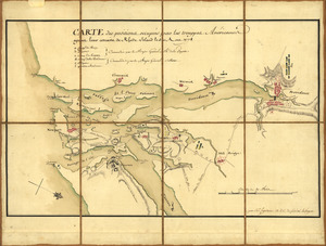
North and Central America
417
United States
294
New York
40
Florida
19
Canada
17
Alabama
15
Chatham (county)
15
Savannah
13
more
Place
»
Topic
Manuscript maps--Early works to 1800
92
Manuscript maps
21
Gulf Coast (U.S.)--Maps, Manuscript--Early works to 1800
12
Fortification--New York (State)--New York--Maps--Early works to 1800
11
New York (N.Y.)--Buildings, structures, etc--Maps, Manuscript--Early works to 1800
9
New York (N.Y.)--Maps, Manuscript--Early works to 1800
8
Saratoga Campaign, N.Y., 1777--Maps, Manuscript--Early works to 1800
8
Coasts--Florida--Maps--Early works to 1800
7
more
Topic
»
Date
Date range begin
–
Date range end
Current results range from
1700
to
1899
View distribution
Creator
Hills, John, (Surveyor)
18
Montrésor, John, 1736-1799
16
Bingham, William, 1752-1804
12
Adlum, John, 1759-1836
10
Washington, George, 1732-1799
9
Faden, William, 1749-1836
7
Morgan, Benjamin, (Draftsman)
7
Wangenheim, Friedrich Adam Julius von
7
more
Creator
»
Format
Maps/Atlases
478
Manuscripts
475
Objects/Artifacts
2
Georeferenced
Yes
5
No
475
Collection
American Revolutionary War-Era Maps
480
Library of Congress Collection
480
Maritime Charts and Atlases
31
Urban Maps
15
Available to use
Creative Commons license
480
Search Constraints
Sort by relevance
relevance
title
date (asc)
date (desc)
Number of results to display per page
50 per page
10
per page
20
per page
50
per page
100
per page
View results as:
grid view
map view
Search Results
1.
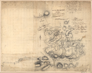
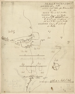
1st. & 2d. position of that part of the army engaged on the 19th Sept. 1777 : 3d & 4th postn. Sept. 19
2.
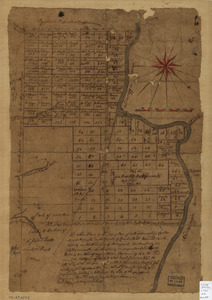
20 tracts, Charleston
3.
20 tracts, Tioga County
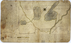
4.
The Above is a plan of the town of Cabot, State of Vermont
5.
The above plan is a discription of a new township called Royalsborough in the county of Cumberland : bounded southeasterly on...
6.
The above plan is a discription of a new township containing the quantity of seven and a half mile of land & water, granted by...
7.
An accurate map of His Majesty's Province of New-Hampshire in New England & all the adjacent country northward to the River St....
8.
Amboy to Elizabethtown
9.
Armée de Rochambeau, 1782 : Carte des environs de Williamsburg en Virginie où les armées françoise et américaine ont...
10.
Armstrong County
11.
Armstrong C[ount]y
12.
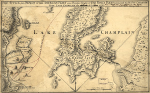
The Attack and defeat of the American fleet under Benedict Arnold : by the King's fleet commanded by Sir Guy Carleton upon Lake...
13.
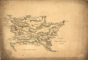
Attacks upon Rhode Island, Augt. 1778
14.
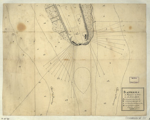
Batteries de West-point au haut de la Rivière d'York
15.
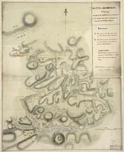
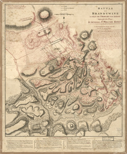
Battle of Brandywine : 11th Septr. 1777, in which the rebels were defeated by the army under the command of General Sir William...
16.
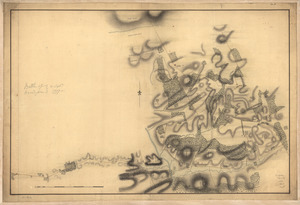
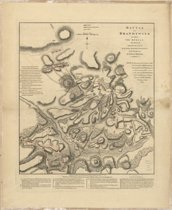
Battle of Brandywine, 11 Septr. 1777
17.
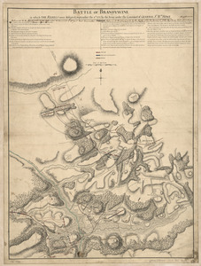
Battle of Brandywine, 11th Septr. 1777 : in which the rebels were defeated by the Army under the command of Genl. Sir Willm. Howe
18.
Battle of Brandywine in which the Americans were defeated : September the 11th, 1777 by General Sr. William Howe
19.
Battle of Brandywine in which the rebels were defeated : September the 11th. 1777, by the army under the command of General Sr....
20.
Battle of Brandywine, in which the rebels were defeated : September the 11th 1777, by the army under the command of General Sr....
21.
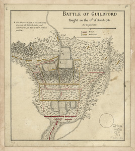
Battle of Guildford fought on the 15 of March 1781
22.
Battle of Guildford fought on the 15th of March 1781
23.
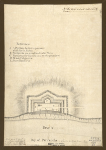
Bay of Pensacola, fortification
24.
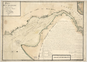
Baye de la Delaware avec les ports, sondes, dangers, bancs, &c. depuis les caps jusqu'a Philadelphie : d'après la carte de...
25.
Bend of the Missouri River
26.
Boston & harbour
27.
Boston Harbor, Massachusetts
28.
Braddock's route, 1755, Fort Cumberland to Fort Pitt
29.
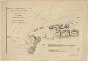
British camp at Trudruffrin from [sic] : with the attack made by Major General Grey against the rebels near White Horse Tavern
30.
British camp at Trudruffrin from the 18th. to the 21st. of September 1777 : with the attack made by Major General Grey against...
31.
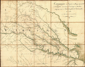
Campagne en Virginie du Major Général M'is de LaFayette : ou se trouvent les camps et marches, ainsy que ceux du Lieutenant...
32.
Cantonment of His Majesty's forces in N. America : according to the disposition now made & to be compleated as soon as...
33.
Cantonment of the forces in North America 11th. Octr. 1765
34.
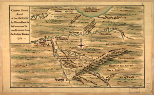
Captain Snow's scetch of the country by himself, and the best accounts he could receive from the Indian traders
35.
Captain Snow's sketch
36.
Carta esférica de la canal entre Puerto Rico y Santo Domingo
37.
Carta esférica de la Ysla de la Granada
38.
Carta esférica de la Ysla de Tabago
39.
Carta esférica de las yslas de Sn. Martin, Sn. Bartolome y Anguila
40.
Carta esférica de las Yslas Virgenes
41.
Carta esférica de las Yslas Virgenes
42.
Carta esférica que comprehende la Ysla de Trinidad con sus adyacentes, bajos, sondas y veriles
43.
Carte de la coste de la province de la Louisiane et des bouches du Micissipy ou fleuve St. Louis
44.
Carte de l'affaire de Montmouth : ou le G'al Washington commandon l'armée américaine et le G'l Clinton l'armée angloise le...
45.
Carte de l'entrée du port et rade de Pensacola
46.
Carte des environs d'Hampton
47.
Carte des positions occupeés par les trouppes Américaines apres leur retraite de Rhode Island le 30 Aout 1778
48.
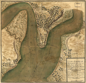
Carte detaillée de West Point sur la rivière d'York au confluent des Rivières de Pamunkey et Matapony
49.
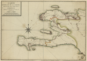
Carte générale de la partie française de l'isle de St. Domingue
50.
Cawanesque
‹ Prev
Next ›
1
2
3
4
5
…
9
10


![Armstrong C[ount]y](https://bpldcassets.blob.core.windows.net/derivatives/images/commonwealth:q524ng353/image_thumbnail_300.jpg)


![British camp at Trudruffrin from [sic]](https://bpldcassets.blob.core.windows.net/derivatives/images/commonwealth:q524nb58k/image_thumbnail_300.jpg)