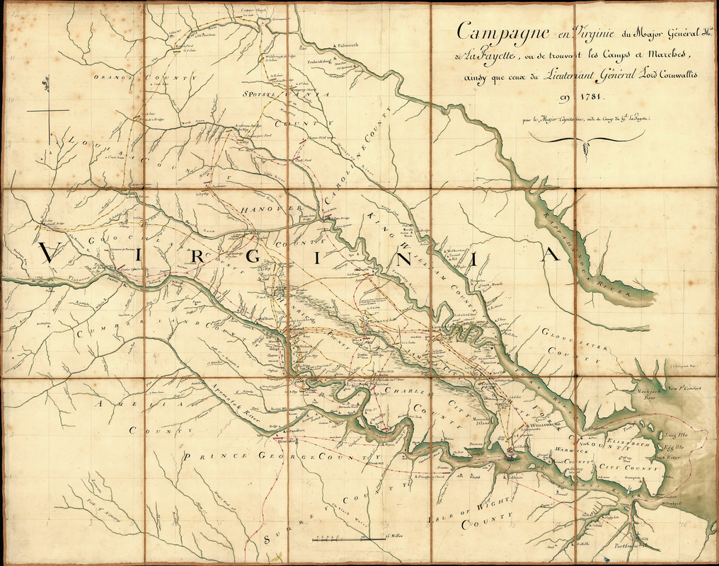
Campagne en Virginie du Major Général M'is de LaFayette : ou se trouvent les camps et marches, ainsy que ceux du Lieutenant Général Lord Cornwallis en 1781
This map is also available in American Revolutionary Geographies Online (ARGO), a collections portal especially built for material relating to the American Revolutionary War Era. Visit ARGO to learn more about this item and explore the historical geography of North America in the late eighteenth century.
Item Information
- Title:
- Campagne en Virginie du Major Général M'is de LaFayette : ou se trouvent les camps et marches, ainsy que ceux du Lieutenant Général Lord Cornwallis en 1781
- Title (alt.):
-
Plan d'une partie de la Virginie
- Creator:
- Capitaine du Chesnoy, Michel, 1746-1804
- Contributor:
- Lafayette, Marie Joseph Paul Yves Roch Gilbert Du Motier, marquis de, 1757-1834
- Name on Item:
-
par le Major Capitaine, aide de camp du G'l LaFayette
- Date:
-
[1781]
- Format:
-
Maps/Atlases
Manuscripts
- Location:
- Library of Congress Geography and Map Division
- Collection (local):
-
Library of Congress Collection
- Subjects:
-
Virginia--History--Revolution, 1775-1783--Maps--Early works to 1800
Virginia--Maps, Manuscript--Early works to 1800
Yorktown (Va.)--History--Siege, 1781--Maps--Early works To 1800
- Places:
-
York (county)Yorktown
- Extent:
- 1 map : ms., col., cloth backing ; 87 x 111 cm.
- Terms of Use:
-
No known copyright restrictions.
This work is licensed for use under a Creative Commons Attribution Non-Commercial Share Alike License (CC BY-NC-SA).

- Scale:
-
Scale [ca. 1:225,000]
- Language:
-
French
- Catalog Record:
-
https://lccn.loc.gov/00558784
- Notes:
-
Covers central Virginia from Orange County in the north to Isle of Wight County in the south, and west to Cumberland County.
Shows selected bridges, houses, churches, taverns, and other points of interest, and includes notes describing dates of military actions in the Yorktown campaign.
Pen-and-ink, watercolors, wash, and lead pencil.
Sectioned to 15 panels and mounted on cloth backing to fold to ca. 29 x 22 cm.
Accompanied by text: Précis de la campagne 1781, pour servir à l'intellige'ce & la carte. [6] p. : ms. ; 29 cm.
Place-names in English, notes in French.
- Notes (date):
-
This date is inferred.
- Identifier:
-
ar300600z