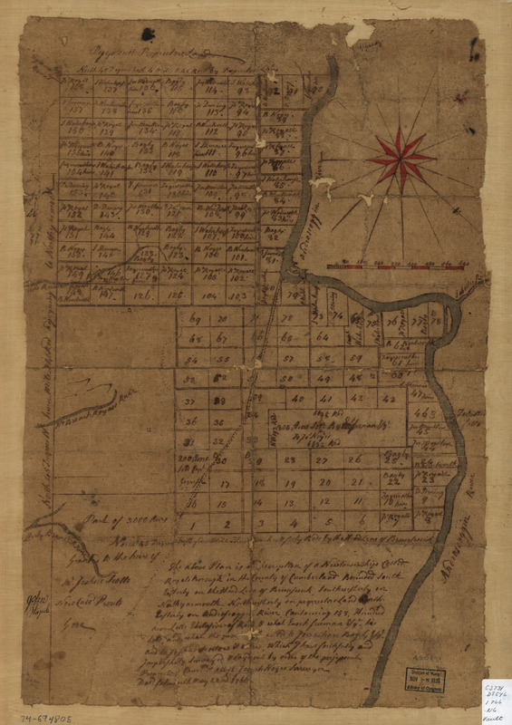
The above plan is a discription of a new township called Royalsborough in the county of Cumberland : bounded southeasterly on the headline of Brunswick, southwesterly on Northyarmouth, northwesterly on proprietors land, northeasterly on Androscoggin River
This map is also available in American Revolutionary Geographies Online (ARGO), a collections portal especially built for material relating to the American Revolutionary War Era. Visit ARGO to learn more about this item and explore the historical geography of North America in the late eighteenth century.
Item Information
- Title:
- The above plan is a discription of a new township called Royalsborough in the county of Cumberland : bounded southeasterly on the headline of Brunswick, southwesterly on Northyarmouth, northwesterly on proprietors land, northeasterly on Androscoggin River
- Title (alt.):
-
Royalsborough in the county of Cumberland
- Creator:
- Noyes, Joseph, 1740-1795
- Name on Item:
-
attest. Joseph Noyes, survayor. Deld. Falmouth, May 22nd, 1766
- Date:
-
[1766]
- Format:
-
Maps/Atlases
Manuscripts
- Location:
- Library of Congress Geography and Map Division
- Collection (local):
-
Library of Congress Collection
- Subjects:
-
Real property--Maine--Durham--Maps--Early works to 1800
Land grants--Maine--Durham--Maps--Early works to 1800
Durham (Me.)--Maps, Manuscript--Early works to 1800
- Places:
-
Town of Durham
- Extent:
- 1 manuscript map : hand color on sheet 54 x 36 cm.
- Terms of Use:
-
No known copyright restrictions.
This work is licensed for use under a Creative Commons Attribution Non-Commercial Share Alike License (CC BY-NC-SA).

- Scale:
-
Scale ca. 1:30,000
- Language:
-
English
- Catalog Record:
-
https://lccn.loc.gov/74694805
- Notes:
-
Manuscript, pen-and-ink and watercolor.
Oriented with north toward the upper right.
Shows township lots and owners.
- Notes (date):
-
This date is inferred.
- Notes (citation):
-
LC Maps of North America, 1750-1789, 834
- Identifier:
-
ar083400


