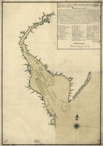
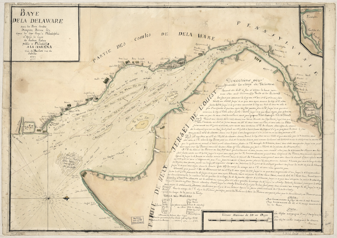
Baye de la Delaware avec les ports, sondes, dangers, bancs, &c. depuis les caps jusqu'a Philadelphie : d'après la carte de Joshua Fisher publie a Philadelfia, à la Havana, Chéz de Moun̂oz, rue du Soléille, 1785, 1777
This map is also available in American Revolutionary Geographies Online (ARGO), a collections portal especially built for material relating to the American Revolutionary War Era. Visit ARGO to learn more about this item and explore the historical geography of North America in the late eighteenth century.
Item Information
- Title:
- Baye de la Delaware avec les ports, sondes, dangers, bancs, &c. depuis les caps jusqu'a Philadelphie : d'après la carte de Joshua Fisher publie a Philadelfia, à la Havana, Chéz de Moun̂oz, rue du Soléille, 1785, 1777
- Creator:
- Ybarra, (Cartographer)
- Contributor:
- Fisher, Joshua, 1707-1783
- Contributor:
- Le Rouge, Georges-Louis
- Contributor:
- Moun̂oz (Firm)
- Name on Item:
-
Ybarra fecit
- Date:
-
[1785]
- Format:
-
Maps/Atlases
Manuscripts
- Location:
- Library of Congress Geography and Map Division
- Collection (local):
-
Library of Congress Collection
- Subjects:
-
Nautical charts--Delaware Bay (Del. and N.J.)--Early works to 1800
Delaware Bay (Del. and N.J.)--Maps, Manuscript--Early works to 1800
Nautical charts--Delaware River (N.Y.-Del. and N.J.)--Early works to 1800
Delaware River (N.Y.-Del. and N.J.)--Maps, Manuscript--Early works to 1800
- Places:
-
Delaware River
Delaware Bay
- Extent:
- 1 manuscript map : hand color 47 x 66 cm.
- Terms of Use:
-
No known copyright restrictions.
This work is licensed for use under a Creative Commons Attribution Non-Commercial Share Alike License (CC BY-NC-SA).

- Scale:
-
Scale ca. 1:200,000
- Language:
-
French
- Catalog Record:
-
https://lccn.loc.gov/74691702
- Notes:
-
Manuscript, pen-and-ink, and watercolor.
Depths shown in fathoms.
Oriented with north to the right.
Place names in English.
Copied from Georges Louis LeRouge's Pilote américain septentrional. 1778. v. 1, pl. no. 14.
Includes "Direcctions pour monter la baye de Delaware" and inset.
- Notes (date):
-
This date is inferred.
- Notes (citation):
-
LC Maps of North America, 1750-1789, 1364
LC Luso-Hispanic World, 818
- Identifier:
-
ar136400