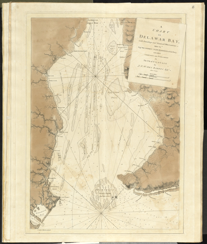
A chart of Delawar Bay, with soundings and nautical observations
This map is also available in American Revolutionary Geographies Online (ARGO), a collections portal especially built for material relating to the American Revolutionary War Era. Visit ARGO to learn more about this item and explore the historical geography of North America in the late eighteenth century.
Item Information
- Title:
- A chart of Delawar Bay, with soundings and nautical observations
- Creator:
- Des Barres, Joseph F. W. (Joseph Frederick Wallet), 1722-1824
- Contributor:
- Hamond, Andrew Snape, Sir, 1738-1828
- Name on Item:
-
Taken by Sir Andrew Snape Hammond and others ; Composed and published ... by J.F.W. Des Barres.
- Date:
-
1779
- Format:
-
Maps/Atlases
- Location:
- George Washington's Mount Vernon
- Collection (local):
-
Richard H. Brown Revolutionary War Map Collection at Mount Vernon
- Subjects:
-
Nautical charts--Delaware Bay (Del. and N.J.)--Early works to 1800
Nautical charts--Delaware River (N.Y.-Del. and N.J.)--Early works to 1800
Delaware Bay (Del. and N.J.)--Maps--Early works to 1800
Delaware River (N.Y.-Del. and N.J.)--Maps--Early works to 1800
- Places:
-
Delaware Bay
Delaware River
- Extent:
- 1 map : col. ; 76 x 53 cm.
- Terms of Use:
-
No known copyright restrictions.
This work is licensed for use under a Creative Commons Attribution Non-Commercial Share Alike License (CC BY-NC-SA).

- Publisher:
-
[London] :
J.F.W. Des Barres
- Scale:
-
Scale ca. 1:150,000
- Language:
-
English
- Catalog Record:
-
MVLA record
- Notes:
-
2nd state.
Relief shown by hachures. Depths shown by soundings.
From volume five of the author's Atlantic Neptune.
- Identifier:
-
06_01_010111
- LCCN:
-
77692984