Toggle navigation
LMEC Home
Exhibitions
Georeferencing
Tools for Teachers
Collections
My Favorites
Sign Up / Log In
Search
Search the map portal
Map Collection
Map Collection
Map Sets
Search
Search
Search for
Search In
All Fields
Creator
Title
Subject
Place
Search All Digital Collections
Advanced Search
306 Results
My Search
Start Over
More Like
commonwealth:z603vv27p
Remove constraint More Like: commonwealth:z603vv27p
Filter your Search
Place
North and Central America
239
United States
174
New York
31
Suffolk (county)
31
Boston
29
Canada
27
North America
27
Delaware Bay
14
more
Place
»
Topic
North America--Maps--Early works to 1800
18
Boston (Mass.)--History--Revolution, 1775-1783--Maps--Early works to 1800
16
Delaware Bay (Del. and N.J.)--Maps--Early works to 1800
10
Nautical charts--Delaware Bay (Del. and N.J.)--Early works to 1800
10
Vues d'optique
10
Gibraltar--History--Siege, 1779-1783--Maps--Early works to 1800
9
New York (N.Y.)--Pictorial works--Early works to 1800
9
United States--History--French and Indian War, 1754-1763--Maps--Early works to 1800
9
more
Topic
»
Date
Date range begin
–
Date range end
Current results range from
1706
to
1816
View distribution
Creator
Faden, William, 1749-1836
33
Jefferys, Thomas, -1771
29
Le Rouge, Georges-Louis
24
Des Barres, Joseph F. W. (Joseph Frederick Wallet), 1722-1824
20
Sayer, Robert, 1725-1794
19
Korn, Christoph Heinrich, 1726-1783
11
Raspe, Gabriel Nicolaus, 1712-1785
11
Simcoe, John Graves, 1752-1806
10
more
Creator
»
Format
Maps/Atlases
263
Prints
32
Manuscripts
27
Drawings/Illustrations
9
Books
2
Georeferenced
Yes
12
No
294
Collection
American Revolutionary War-Era Maps
303
Richard H. Brown Revolutionary War Map Collection at Mount Vernon
293
Maritime Charts and Atlases
9
Norman B. Leventhal Map & Education Center Collection
8
Boston and New England Maps
4
Library of Congress Collection
4
Urban Maps
3
MacLean Collection Map Library
1
Available to use
Creative Commons license
297
No known restrictions
8
Search Constraints
Sort by relevance
relevance
title
date (asc)
date (desc)
Number of results to display per page
20 per page
10
per page
20
per page
50
per page
100
per page
View results as:
grid view
map view
Search Results
1.
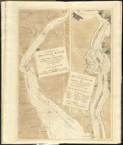
A chart of Delaware Bay and River, containing a full and exact description of the shores, creeks, harbours, soundings, shoals,...
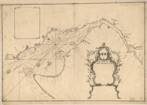
2.
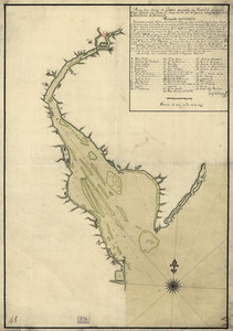
A chart of Delawar River from Bombay Hook to Ridley Creek, with soundings &c taken by Lt. Knight of the Navy
3.
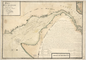
Baye de la Delaware avec les ports, sondes, dangers, bancs, &c. depuis les caps jusqu'a Philadelphie : d'après la carte de...
4.
Plano de la Bahia de la Ware y entrada de Filadelfie
5.
Carte de la Baye et Riviere de Délaware : contenant une éxacte et entiére description des rivages, criques, havres, sondes,...
6.
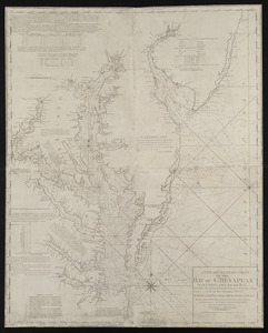
A new and accurate chart of the Bay of Chesapeak including Delaware Bay with all the shoals, channels, islands, entrances,...
7.
A new and accurate chart of the Bay of Chesapeak including Delaware Bay with all the shoals, channels, islands, entrances,...
8.
A new and accurate chart of the Bay of Chesapeak including Delaware Bay with all the shoals, channels, islands, entrances,...
9.
Virginia, Maryland, Pennsilvania, east & west New Jarsey
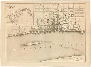
10.
A plan of the city of Philadelphia, the capital of Pennsylvania, from an actual survey
11.
A draught of Delaware Bay
12.
Plano de Philadelphia
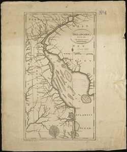
13.
Delaware, from the best authorities
14.
A plan of the city of Philadelphia, the capital of Pennsylvania, from an actual survey
15.
A plan of the city of Philadelphia, the capital of Pennsylvania, from an actual survey
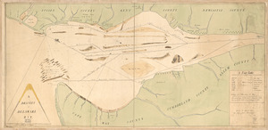
16.
[A map of part of Pennsylvania & Maryland intended to shew, at one view, the several places proposed for opening a...
17.
Abriss der stadt Gibraltar und der darinn befindlichen festen platze, nebst dem meerbusen von Algesiras
18.
An accurate map of His Majesty's province of New-Hampshire in New England : taken from actual surveys of all the inhabited...
19.
An accurate map of Staten Island : with that part of New York, Long Island and the Jerseys, which is the rendesvous of the two...
20.
An accurate map of the country round Boston in New England from the best authorities
‹ Prev
Next ›
1
2
3
4
5
…
15
16


![[A map of part of Pennsylvania & Maryland intended to shew, at one view, the several places proposed for opening a communication between the waters of the Delaware & Chesopeak Bays]](https://bpldcassets.blob.core.windows.net/derivatives/images/commonwealth:z603vt12v/image_thumbnail_300.jpg)


