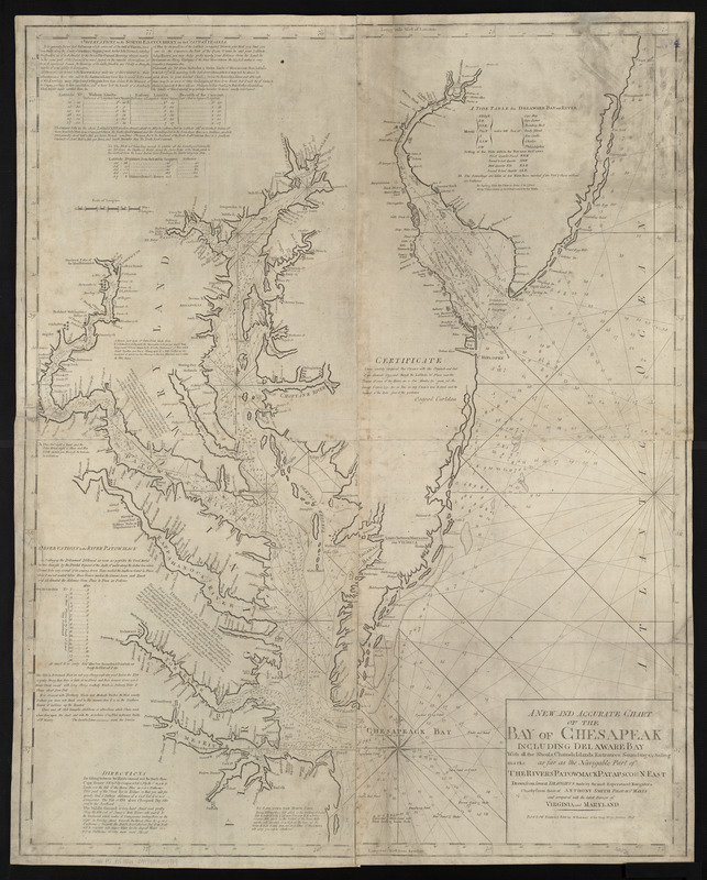
A new and accurate chart of the Bay of Chesapeak including Delaware Bay with all the shoals, channels, islands, entrances, soundings, & sailing marks as far as the navigable part of the rivers Patowmack Patapsco & N. East
Item Information
- Title:
- A new and accurate chart of the Bay of Chesapeak including Delaware Bay with all the shoals, channels, islands, entrances, soundings, & sailing marks as far as the navigable part of the rivers Patowmack Patapsco & N. East
- Creator:
- Smith, Anthony, pilot of St. Marys
- Cartographer:
- Smith, Anthony, pilot of St. Marys
- Publisher:
- Allen, Andrew J., 1784 or 1785-1863
- Name on Item:
-
drawn from several draughts made by the most experienced navigators chiefly from those of Anthony Smith pilot of St. Marys and compared with the latest surveys of Virginia and Maryland
- Date:
-
[1816]
- Format:
-
Maps/Atlases
- Location:
-
Boston Public Library
Norman B. Leventhal Map & Education Center - Collection (local):
-
Norman B. Leventhal Map & Education Center Collection
- Subjects:
-
Coasts--Delaware--Early works to 1800
Coasts--Maryland--Early works to 1800
Coasts--New Jersey--Early works to 1800
Coasts--Virginia--Early works to 1800
Nautical charts--Delaware Bay (Del. and N.J.)--Early works to 1800
Nautical charts--Chesapeake Bay (Md. and Va.)--Early works to 1800
Delaware Bay (Del. and N.J.)--Maps--Early works to 1800
Chesapeake Bay (Md. and Va.)--Maps--Early works to 1800
- Places:
-
Delaware Bay
Chesapeake Bay
- Extent:
- 1 map ; 103 x 81 cm
- Terms of Use:
-
No known copyright restrictions.
No known restrictions on use.
- Publisher:
-
Boston :
W. Norman [that is, Andrew J. Allen]
- Scale:
-
Scale approximately 1:347,500
- Language:
-
English
- Notes:
-
Depths shown by soundings.
Includes notes, tables and certificate.
In The American pilot. Boston : Andrew J. Allen, [1816].
- Notes (date):
-
This date is inferred.
- Identifier:
-
06_01_004813
- Call #:
-
G1106.P5 A4 1816x
- Barcode:
-
30000005069388

 IIIF Manifest