Toggle navigation
LMEC Home
Exhibitions
Georeferencing
Tools for Teachers
Collections
My Favorites
Sign Up / Log In
Search
Search the map portal
Map Collection
Map Collection
Map Sets
Search
Search
Search for
Search In
All Fields
Creator
Title
Subject
Place
Search All Digital Collections
Advanced Search
134 Results
My Search
Start Over
More Like
commonwealth:q524n611v
Remove constraint More Like: commonwealth:q524n611v
Filter your Search
Place
North and Central America
127
United States
109
New England
90
Massachusetts
31
Middle Atlantic
20
Canada
13
Rhode Island
11
Northeastern United States
10
more
Place
»
Topic
New England--Maps--Early works to 1800
91
Massachusetts--Maps--Early works to 1800
30
Middle Atlantic States--Maps--Early works to 1800
20
Rhode Island--Maps--Early works to 1800
11
Northeastern States--Maps--Early works to 1800
10
Connecticut--Maps--Early works to 1800
8
New York (State)--Maps--Early works to 1800
8
Boston (Mass.)--Maps--Early works to 1800
7
more
Topic
»
Date
Date range begin
–
Date range end
Current results range from
1483
to
1999
View distribution
Creator
Jefferys, Thomas, d. 1771
8
Des Barres, Joseph F. W. (Joseph Frederick Wallet), 1722-1824
5
Bachelder, John B. (John Badger), 1825-1894
4
Bellin, Jacques Nicolas, 1703-1772
4
Green, John, d. 1757
4
Jefferys, Thomas, -1771
4
Bien, Julius, 1826-1909
3
Bowles, Carington, 1724-1793
3
more
Creator
»
Format
Maps/Atlases
129
Manuscripts
5
Photographs
3
Books
1
Documents
1
Georeferenced
Yes
11
No
123
Collection
Norman B. Leventhal Map Center Collection
94
American Revolutionary War-Era Maps
72
Boston and New England Maps
46
Mapping Boston Collection
24
Sidney R. Knafel Map Collection at Phillips Academy
19
Maritime Charts and Atlases
14
Richard H. Brown Revolutionary War Map Collection at Mount Vernon
8
British Library Collection
4
more
Collection
»
Available to use
No known restrictions
70
Creative Commons license
42
Search Constraints
Sort by title
relevance
title
date (asc)
date (desc)
Number of results to display per page
50 per page
10
per page
20
per page
50
per page
100
per page
View results as:
grid view
map view
Search Results
1.
An Accurate map of New Hampshire in New England, from a late survey
2.
An accurate map of Rhode Island, part of Connecticut and Massachusets, shewing Admiral Arbuthnot's station in blocking up...
3.
An accurate map of Rhode Island, part of Connecticut and Massachusets, shewing Admiral Arbuthnot's station in blocking up...
4.
An accurate map of the Commonwealth of Massachusetts exclusive of the district of Maine : compiled pursuant to an Act of the...
5.
An accurate map of the country round Boston in New England from the best authorities
6.
An accurate map of the country round Boston in New England from the best authorities
7.
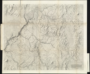
An accurate map of the four New England states : shewing in a distinct manner all the mountains, forts, rivers, swamps,...
8.
An actual survey of the sea coast from New York to the I. Cape Brition : with tables of the direct and thwart courses &...
9.
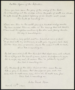
Battle hymn of the republic
10.
Belgii Novi, Angliae Novae, et partis Virginiae : novissima delineatio
11.
Bowles's map of the seat of war in New England, comprehending the provinces of Massachusets Bay, and New Hampshire : with the...
12.
Bowles's new pocket map of the most inhabited part of New England : comprehending the provinces of Massachusets Bay and New...
13.
Bowles's new pocket map of the most inhabited part of New England : comprehending the provinces of Massachusets Bay and New...
14.
Carta particolare della nuoua Belgia è parte della nuoua Anglia
15.
Carta rappresentante il porto di Boston
16.
Carte de la Nouvelle Angleterre, comprenant les etats de Massachusets Bay, N. Hamp Shire, Connecticut et Rhode Island
17.
Carte de la Nouvelle Angleterre, New York, Pensilvanie et Nouveau Jersay suivant les cartes angloises
18.
Carte de la Nouvelle Angleterre, Nouvelle Yorck, et Pensilvanie : pour servir à l'Histoire générale des voyages
19.
Carte de la Nouvelle Angleterre, Nouvelle York, Nouvelle Jersey et Pensilvanie
20.
Carte des environs de Boston, capitale de la Nlle. Angleterre en Amerique
21.
Carte d'une partie de l'Amérique Septentrionale : pour servir à l'intellegence du mémoire sur les prétentions des Anglois...
22.
Carte generale du Canada ou Nouvelle France
23.
Carte réduite du nord des Etat-Unis avec l'intérieur du pays : pour servir à l'intelligence de cette histoire ; copieé par...
24.
Chart for the journal of Mr. le Mquis. de Chastellux
25.
A chart of the coast of America from New found Land to Cape Cod
26.
A chart of the coast of New England from the South Shoal to Cape Sable including Georges Bay from Holland & actual surveys
27.
A chart of the coast of New England from the South Shoal to Cape Sable including Georges Bay from Holland & actual surveys
28.
A chart of the province of New England, with the soundings on the coast; drawn about 1670, on a scale of 1 2/3 English league...
29.
Circular world map
30.
Coast of Massachusetts from Cape Ann to Manomet Point, including northern tip of Cape Cod
31.
Coast of Massachusetts from Cape Ann to Manomet Point, including northern tip of Cape Cod
32.
The coast of New England
33.
[Coast of New England from Chatham Harbor to Naragansett Bay]
34.
[Coast of New England from Chatham Harbor to Naragansett Bay]
35.
A Copy of the Plan returned by his Maj:tys Com:rs for setling the Boundarys between the Provinces of New Hampshire and the...
36.
A correct map of the coast of New England
37.
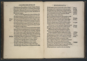
Cosmographiae introductio
38.
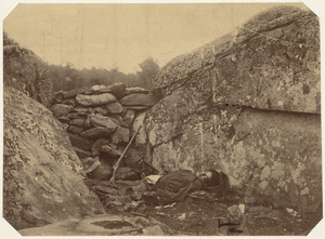
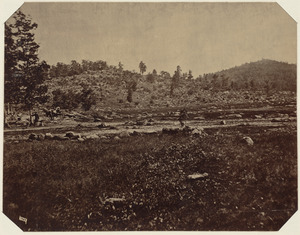
Dead rebel sharpshooter at Gettysburg
39.
An exact map of New England, New York, Pensylvania & New Jersey, from the latest surveys
40.
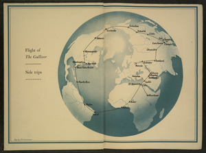
Flight of "The Gulliver"
41.
Die gegend um Boston
42.
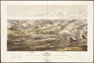
Gettysburg battle-field : Battle fought at Gettysburg, Pa., July 1st, 2d & 3d, 1863 by the Federal and Confederate armies,...
43.
Karte von dem Ostlichen-Stucke von Neu Franckreich oder Canada in America : besonders aber Acadia und Neu Schottland
44.
Karte von Neu England, Neu Yorck und Pensilvanien
45.
Little Round Top, Gettysburg, July 1863
46.
A map of 100 miles round Boston
47.
Map of American camp in New Jersey and surrounding countryside
48.
[Map of eastern Massachusetts and vicinity]
49.
Map of explorations and surveys in New Mexico and Utah made under the direction of the Secretary of War by Capt. J. N. Macomb...
50.
A map of Massachusetts, from the best authorities
‹ Prev
Next ›
1
2
3


![[Coast of New England from Chatham Harbor to Naragansett Bay]](https://bpldcassets.blob.core.windows.net/derivatives/images/commonwealth:7h149x27g/image_thumbnail_300.jpg)
![[Coast of New England from Chatham Harbor to Naragansett Bay]](https://bpldcassets.blob.core.windows.net/derivatives/images/commonwealth:7h149z37x/image_thumbnail_300.jpg)


![[Map of eastern Massachusetts and vicinity]](https://bpldcassets.blob.core.windows.net/derivatives/images/commonwealth:9s161d29f/image_thumbnail_300.jpg)