Toggle navigation
LMEC Home
Exhibitions
Georeferencing
Tools for Teachers
Collections
My Favorites
Sign Up / Log In
Search
Search the map portal
Map Collection
Map Collection
Map Sets
Search
Search
Search for
Search In
All Fields
Creator
Title
Subject
Place
Search All Digital Collections
Advanced Search
112 Results
My Search
Start Over
More Like
commonwealth:j3860821t
Remove constraint More Like: commonwealth:j3860821t
Filter your Search
Place
North and Central America
69
United States
35
New England
21
New York
19
Massachusetts
16
New Jersey
9
Rhode Island
8
Connecticut
6
more
Place
»
Topic
New England--Maps--Early works to 1800
15
New Jersey--History--Revolution, 1775-1783--Maps--Early works to 1800
14
World maps--Early works to 1800
13
Fortification--New York (State)--New York--Maps--Early works to 1800
12
America--Maps--Early works to 1800
9
New York (N.Y.)--Buildings, structures, etc--Maps, Manuscript--Early works to 1800
9
New York (State)--History--Revolution, 1775-1783--Maps--Early works to 1800
9
Massachusetts--Maps
8
more
Topic
»
Date
Date range begin
–
Date range end
Current results range from
1482
to
1990
View distribution
Creator
Faden, William, 1749-1836
6
Ortelius, Abraham, 1527-1598
5
Bordon, Benedetto, 1450-1530
3
Gastaldi, Giacomo, approximately 1500-approximately 1565
3
Hondius, Jodocus, 1594 or 1595-1629
3
Mercator, Gerhard, 1512-1594
3
Münster, Sebastian, 1489-1552
3
Ptolemy, active 2nd century
3
more
Creator
»
Format
Maps/Atlases
112
Manuscripts
12
Books
1
Georeferenced
Yes
9
No
103
Collection
Sidney R. Knafel Map Collection at Phillips Academy
87
American Revolutionary War-Era Maps
49
Library of Congress Collection
11
Norman B. Leventhal Map Center Collection
8
Richard H. Brown Revolutionary War Map Collection at Mount Vernon
4
Boston and New England Maps
1
Harvard Map Collection
1
New-York Historical Society Collection
1
Available to use
Creative Commons license
16
No known restrictions
9
Search Constraints
Sort by date (desc)
relevance
title
date (asc)
date (desc)
Number of results to display per page
50 per page
10
per page
20
per page
50
per page
100
per page
View results as:
grid view
map view
Search Results
1.
Sketch A showing the progress of the survey in section no. 1 from 1844 to 1881
2.
Old Colony Railroad and connections
3.
Barnstable County, Dukes County and Nantucket Island, Massachusetts
4.
Old Colony & Newport railway and its connections
5.
Massachusetts and Rhode Island
6.
Preliminary sketch showing the positions of Davis' Shoal and other dangers recently discovered by the Coast Survey and the...
7.
Sketch A No. 5 showing proposed site for a light house on Sow and Pigs Reef
8.
The harbor of Holmes' Hole
9.
Massachusetts
10.
Massachusetts
11.
Geological map of Massachusetts
12.
Map of the northern part of New England : compiled for Pres't. Dwight's travels
13.
Map of the southern part of New England : compiled for Pres't. Dwights travels
14.
The state of Massachusetts
15.
Map of Massachusetts, from the best authorities
16.
The American pilot : containing the navigation of the sea coat of North America . . .
17.
Massachusetts
18.
The state of Massachusetts from the best information
19.
A map of Massachusetts, from the best authorities
20.
Map of the northern, or, New England states of America, comprehending Vermont, New Hampshire, District of Main, Massachusetts,...
21.
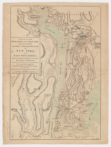
A plan of the operations of the King's army under the command of General Sr. William Howe, K.B. in New York and east New Jersey...
22.
Chart for the journal of Mr. le Mquis. de Chastellux
23.
Carte de la Nouvelle Angleterre, Nouvelle York, Nouvelle Jersey et Pensilvanie
24.
A map of the province of Massachusets Bay and colony of Rhode Island, with part of Connecticut, New Hampshire, and Vermont
25.
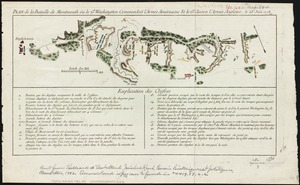
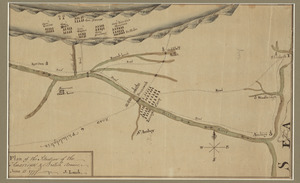
Plan de la bataille de Montmouth où le Gl. Washington commandait l'Armée Américaine et le Gl. Clinton l'Armée Anglaise, le...
26.
Chart and plan of the harbour of New York & the couny. adjacent, from Sandy Hook to Kingsbridge, comprehending the whole of New...
27.
Nord de l'Ile de New-York
28.
Plan de New-York et les environs
29.
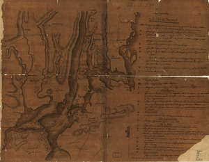
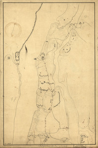
Reconnoissance de King's bridge : I
30.
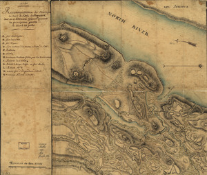
Reconnoissance des ouvrages du nord de l'Isle de Newyork dont on a déterminé géometriquement les principaux points le 22 et...
31.
An accurate map of Rhode Island, part of Connecticut and Massachusets, shewing Admiral Arbuthnot's station in blocking up...
32.
A new and accurate map of the colony of Massachusets Bay, in North America, from a late survey
33.
A new and accurate map of the province of New York and part of the Jerseys, New England and Canada, shewing the scenes of our...
34.
The American Atlas or, A Geographical Description of the whole continent of America : wherein are delineated at large, its...
35.
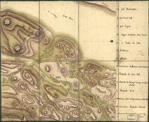
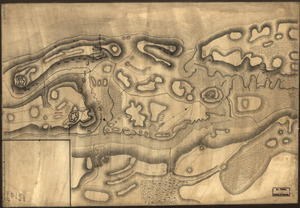
Disposition of British troops, with fortifications north of Fort Knipehausen, i.e. Fort Washington to Fort Independence
36.
Map of defenses of New York Island from Fort Washington to Fort Independence, with redoubts, etc. planned between
37.
A New and accurate map of the present seat of war in North America, comprehending New Jersey, Philadelphia, Pensylvania,...
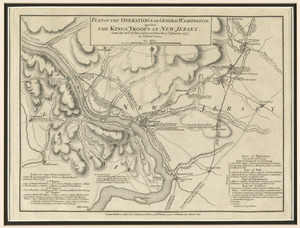
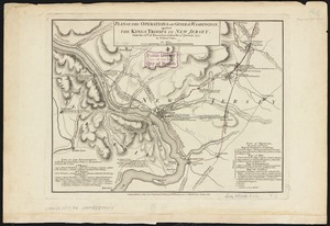
38.
Plan of the operations of General Washington, against the Kings troops in New Jersey : from the 26th. of December 1776, to the...
39.
Plan of the operations of General Washington, against the Kings troops in New Jersey : from the 26th. of December 1776, to the...
40.
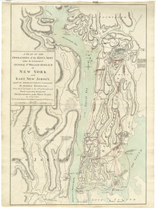
A plan of the operations of the King's army : under the command of General Sr. William Howe, K.B. in New York and east New...
41.
A plan of the operations of the King's army under the command of General Sr. William Howe, K.B. in New York and east New...
42.
A plan of the operations of the King's army under the command of General Sr. William Howe, K.B. in New York and east New Jersey...
43.
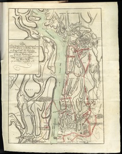
Plan of the situation of the American & British armies, June 15st 1777
44.
Plan von den operationen der Koeniglichen Armee unter dem General Sir William Howe : in Neuyorck und Ost-Neujerseÿ gegen die...
45.
Plan von den operationen der Koeniglichen Armee unter dem General Sir William Howe : in Neuyorck und Ost-Neujerseÿ gegen die...
46.
Sketch of the Heights of Kingsbridge 1777, with the proposed redoubts coloured orange : Old rebel works coloured black
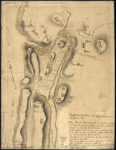
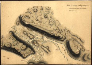
47.
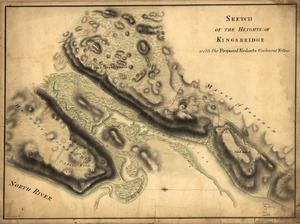
Sketch of the Heights of Kingsbridge, with the proposed redouts couloured yellow
48.
Bowles's new pocket map of the most inhabited part of New England : comprehending the provinces of Massachusets Bay and New...
49.
New York Island : Military; unfinished
50.
A plan of New York Island, with part of Long Island, Staten Island & east New Jersey, with a particular description of the...
‹ Prev
Next ›
1
2
3