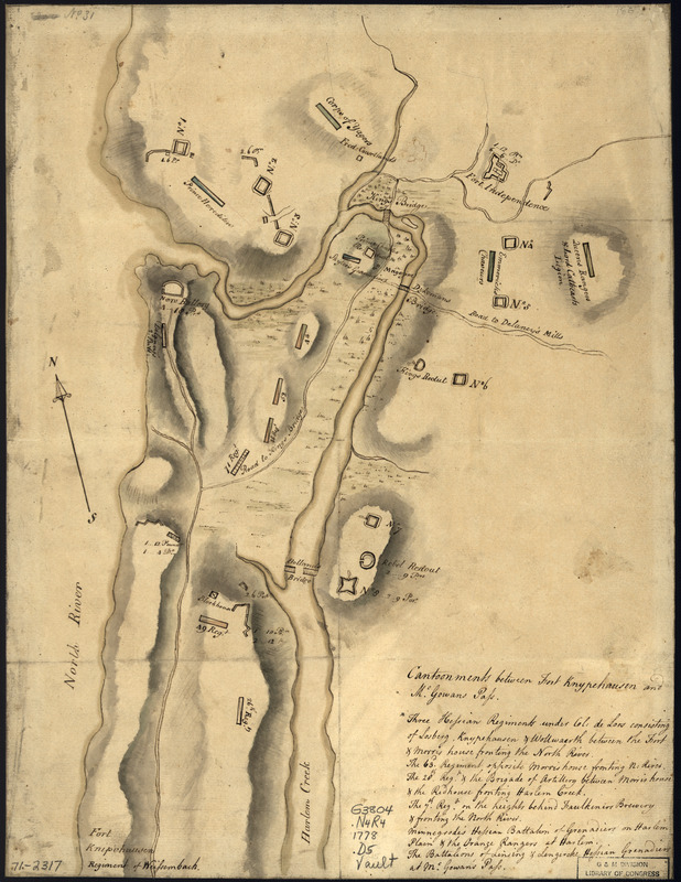
Disposition of British troops, with fortifications north of Fort Knipehausen, i.e. Fort Washington to Fort Independence
This map is also available in American Revolutionary Geographies Online (ARGO), a collections portal especially built for material relating to the American Revolutionary War Era. Visit ARGO to learn more about this item and explore the historical geography of North America in the late eighteenth century.
Item Information
- Title:
- Disposition of British troops, with fortifications north of Fort Knipehausen, i.e. Fort Washington to Fort Independence
- Title (alt.):
-
Cantoonments between Fort Knypehausen and McGowans Pass
- Creator:
- Montrésor, John, 1736-1799
- Date:
-
[1778?]
- Format:
-
Maps/Atlases
Manuscripts
- Location:
- Library of Congress Geography and Map Division
- Collection (local):
-
Library of Congress Collection
- Subjects:
-
Fortification--New York (State)--New York--Maps--Early works to 1800
New York (N.Y.)--Buildings, structures, etc--Maps, Manuscript--Early works to 1800
United States--History--Revolution, 1775-1783--British forces--Maps, Manuscript--Early works to 1800
- Places:
-
New York
- Extent:
- 1 manuscript map : hand color, on sheet 41 x 31 cm.
- Terms of Use:
-
No known copyright restrictions.
This work is licensed for use under a Creative Commons Attribution Non-Commercial Share Alike License (CC BY-NC-SA).

- Scale:
-
Scale ca. 1:10,600
- Language:
-
English
- Catalog Record:
-
https://lccn.loc.gov/gm71002317
- Notes:
-
Manuscript, pen-and-ink and watercolor.
Has watermarks.
Shows military unit members.
"No. 31."
Stamped on label on verso: Montresor.
Includes table "Cantoonments between Fort Knypehausen and McGowans Pass."
- Notes (citation):
-
LC Maps of North America, 1750-1789, 1167
- Identifier:
-
ar116700