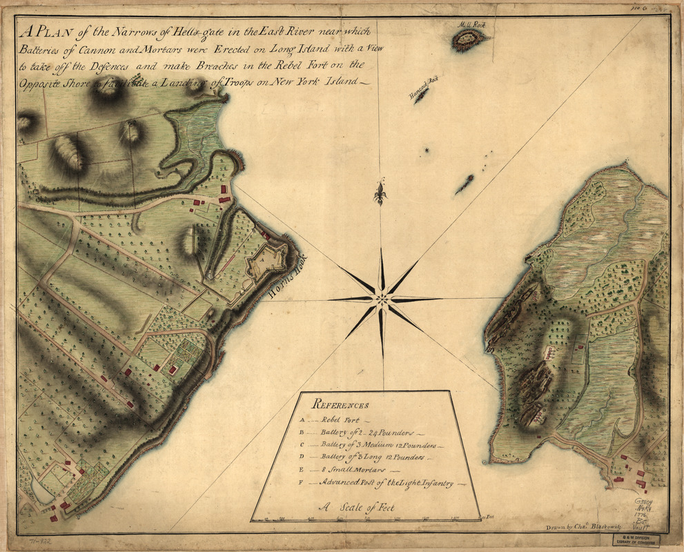
A plan of the Narrows of Hells-gate in the East River : near which batteries of cannon and mortars were erected on Long Island with a view to take off the defences and make breaches in the rebel fort on the opposite shore to facilitate a landing of troops on New York Island
This map is also available in American Revolutionary Geographies Online (ARGO), a collections portal especially built for material relating to the American Revolutionary War Era. Visit ARGO to learn more about this item and explore the historical geography of North America in the late eighteenth century.
Item Information
- Title:
- A plan of the Narrows of Hells-gate in the East River : near which batteries of cannon and mortars were erected on Long Island with a view to take off the defences and make breaches in the rebel fort on the opposite shore to facilitate a landing of troops on New York Island
- Creator:
- Blaskowitz, Charles
- Name on Item:
-
Drawn by Chals. Blaskowitz
- Date:
-
[1776]
- Format:
-
Maps/Atlases
Manuscripts
- Location:
- Library of Congress Geography and Map Division
- Collection (local):
-
Library of Congress Collection
- Subjects:
-
Fortification--New York (State)--New York--Maps--Early works to 1800
New York (N.Y.)--Buildings, structures, etc--Maps, Manuscript--Early works to 1800
Hell Gate (New York, N.Y.)--Maps, Manuscript--Early works to 1800
- Places:
-
New York (county)Hell Gate (channel)
- Extent:
- 1 manuscript map : hand color, 46 x 59 cm.
- Terms of Use:
-
No known copyright restrictions.
This work is licensed for use under a Creative Commons Attribution Non-Commercial Share Alike License (CC BY-NC-SA).

- Scale:
-
Scale ca. 1:2,400
- Language:
-
English
- Catalog Record:
-
https://lccn.loc.gov/gm71000922
- Notes:
-
Manuscript, pen-and-ink and watercolor.
Has watermarks.
Relief shown by shading.
In upper margin: no. 6.
Includes "References."
- Notes (date):
-
This date is inferred.
- Notes (citation):
-
LC Maps of North America, 1750-1789, 1154
- Identifier:
-
ar115400