Toggle navigation
LMEC Home
Exhibitions
Georeferencing
Tools for Teachers
Collections
My Favorites
Sign Up / Log In
Search
Search the map portal
Map Collection
Map Collection
Map Sets
Search
Search
Search for
Search In
All Fields
Creator
Title
Subject
Place
Search All Digital Collections
Advanced Search
494 Results
My Search
Start Over
More Like
commonwealth:z603vv06x
Remove constraint More Like: commonwealth:z603vv06x
Filter your Search
Place
North and Central America
263
United States
178
North America
176
South America
49
Canada
43
New York
34
Suffolk (county)
31
Boston
29
more
Place
»
Topic
North America--Maps--Early works to 1800
180
South America--Maps--Early works to 1800
46
United States--Maps--Early works to 1800
20
Boston (Mass.)--History--Revolution, 1775-1783--Maps--Early works to 1800
16
Great Britain--Colonies--America--Maps--Early works to 1800
15
Canada--Maps--Early works to 1800
14
New England--Maps--Early works to 1800
11
United States--History--French and Indian War, 1754-1763--Maps--Early works to 1800
11
more
Topic
»
Date
Date range begin
–
Date range end
Current results range from
1528
to
1850
View distribution
Creator
Jefferys, Thomas, -1771
40
Faden, William, 1749-1836
34
Sayer, Robert, 1725-1794
29
Le Rouge, Georges-Louis
24
Des Barres, Joseph F. W. (Joseph Frederick Wallet), 1722-1824
21
Moll, Herman, d. 1732
18
Mitchell, John, 1711-1768
14
Korn, Christoph Heinrich, 1726-1783
11
more
Creator
»
Format
Maps/Atlases
451
Prints
32
Manuscripts
25
Drawings/Illustrations
9
Books
2
Georeferenced
Yes
17
No
477
Collection
American Revolutionary War-Era Maps
392
Richard H. Brown Revolutionary War Map Collection at Mount Vernon
293
Norman B. Leventhal Map Center Collection
150
New York Public Library Collection
32
Mapping Boston Collection
9
Sidney R. Knafel Map Collection at Phillips Academy
8
Boston and New England Maps
6
Maritime Charts and Atlases
4
more
Collection
»
Available to use
Creative Commons license
339
No known restrictions
144
Search Constraints
Sort by relevance
relevance
title
date (asc)
date (desc)
Number of results to display per page
50 per page
10
per page
20
per page
50
per page
100
per page
View results as:
grid view
map view
Search Results
401.
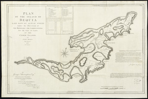
Plan of the island of Bequia laid down by actual survey under the direction of the honorable the Commissioners for the Sale of...
402.
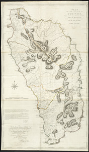
Plan of the island of Dominica laid down by actual survey under the direction of the honorable the Commissioners for the Sale...
403.
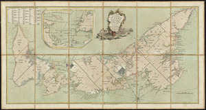
A plan of the island of St. John with the divisions of the counties, parishes, & the lots as granted by government, likewise...
404.
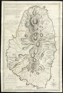
Plan of the island of St. Vincent laid down by actual survey under the direction of the honorable the Commissioners for the...
405.
Plan of the island of Tobago laid down by actual survey under the direction of the honorable the Commissioners for the Sale of...
406.
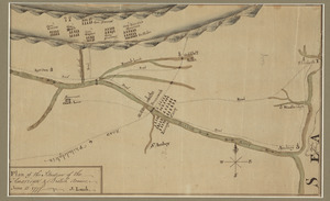
A plan of the line of march of the detachment from the little Meadows
407.
A plan of the line of march with the whole baggage
408.
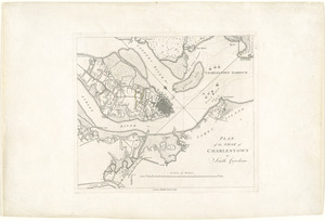
A plan of the military operations against Charlestown, the army being commanded by L.G. Sir Henry Clinton K.B. and the fleet by...
409.
Plan of the operations of General Washington, against the Kings troops in New Jersey : from the 26th. of December 1776, to the...
410.
A plan of the operations of the King's army under the command of General Sr. William Howe, K.B. in New York and east New Jersey...
411.
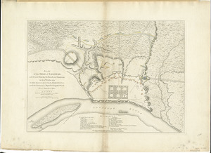
Plan of the siege of Charlestown in South Carolina
412.
Plan of the siege of Savannah : with the joint attack of the French and Americans on the 9th October 1779 : in which they were...
413.
Plan of the situation of the American & British armies, June 15st 1777
414.
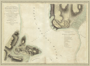
A plan of the surprise of Stoney Point, by a detachment of the American army commanded by Brigr. Genl. Wayne, on the 15th July...
415.
A plan of the town of Boston with the intrenchments & ca. of His Majesty's forces in 1775 : from the observations of Lieut....
416.
A plan of the town of Boston, with the intrenchments &c. of His Majestys forces in 1775 : from the observations of Lieut. Page...
417.
A plan of the town of Newport in Rhode Island
418.
Plan of the town of St. Augustine, the capital of East Florida ; The bay of Espiritu Santo, on the western coast of East Florida
419.
A plan of York Town and Gloucester, in the province of Virginia, shewing the works constructed for the defence of those posts...
420.
Plan von den operationen der Koeniglichen Armee unter dem General Sir William Howe : in Neuyorck und Ost-Neujerseÿ gegen die...
421.
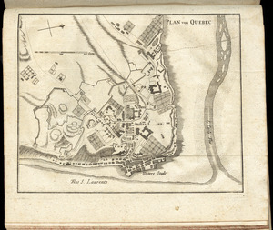
Plan von Quebec
422.
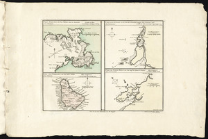
Port, baye cul de sac Royal dans la Martinique -- Isle des Barbades une des Isles Antilles -- Cartagene située sur le Côte de...
423.
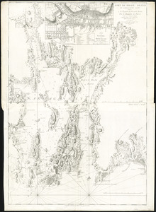
Port de Rhode Island et Narraganset Baye : publié à la requête du Vicomte Howe par le Chevalier des Barres ; traduit de...
424.
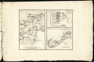
Port de St. Augustin -- Port de la Providence -- La Havane dans l'isle de Cuba -- Baye de Sn. Iago dans l'isle de Cuba -- Port...
425.
Ports de la Nouvelle York et de Pertamboy -- Plan de la ville et du port de Charles Town dans la Caroline Méridionale -- I. de...
426.
Position der Koenigl;Grosbrittanischen und derer vereinigten provinzial armée in New York und dem Jerseys in Nord America im...
427.
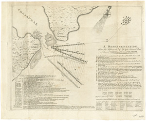
Position of the detachment under Lieut. Col. Baum, at Walmscock near Bennington shewing the attacks of the enemy on the 16th...
428.
The position of the English and French fleets on the 12th of April 1782 at 10 oclock in the morning
429.
La premiere representation de les X batteries flottantes
430.
Prospect der grossen plazes gegn der alten Sud Kirche der Presbiterianer zu Boston = : Vuë de la Rue grande vers l'Eglise du...
431.
Prospect der König Strasse gegen das land thor zu Boston = : Vuë de la Rue du Roi vers la porte de la campagne a Boston
432.
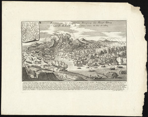
Prospect von Gibraltar mit seinen werken, umliegenden gegenden und iezigen neuern belagerungs anstalten : gezeichnet vor...
433.
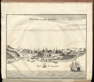
Prospect von Quebec
434.
A prospective view of the battle fought near Lake George, on the 8th of Sepr. 1755, between 2000 English, with 250 Mohawks,...
435.
Province de New-Jersey divisée en est et ouest nomée vulgairement les Jerseys
436.
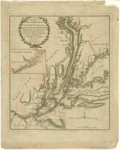
The province of New Jersey, divided into east and west, commonly called the Jerseys
437.
Reddition de l'armée Angloises commandée par Mylord Comte de Cornwallis aux armees combinées des Etats Unis de l'Amerique et...
438.
Relation von der vergeblichen belagrung der haupt vestung Gibraltar : anno 1782 von 13 bis 17 sbre
439.
Remarques sur la navigation de terre-neuve à New-York afin d'eviter les courrants et les bas-fonds au sud de Nantuckett et du...
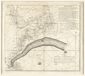
440.
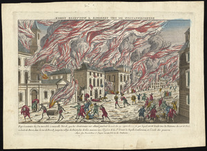
Représentation du feu terrible à Nouvelle Yorck, que les Américains ont allumé pendant la nuit du 19 Septembre 1776 ... et...
441.
A representation, of the sea fight, on the 5th of Sepr. 1781, between Rear Admiral Graves and the Count de Grasse
442.
Schauplatz des Kriegs zwischen Engelland und seinen Collonien in America
443.
Schauplatz des Kriegs zwischen Engelland und seinen Collonien in America
444.
The seat of action, between the British and American forces : or an authentic plan of the western part of Long Island, with the...
445.
The seat of war in New England, by an American volunteer : with the marches of the several corps sent by the Colonies towards...
446.
Sketch of part of the island of Ste. Lucie : computed at about 2500 feet to 1 inch
447.
Sketch of the action at Osburns, April 27th. 1781
448.
A sketch of the action between the British forces and the American provincials, on the heights of the peninsula of Charlestown,...
449.
A sketch of the battle near Camden in South Carolina, 16 Augst. 1780
450.
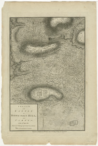
Sketch of the battle of Hobkirks Hill, near Camden, on the 25th April 1781
‹ Prev
Next ›
1
2
…
5
6
7
8
9
10