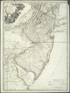
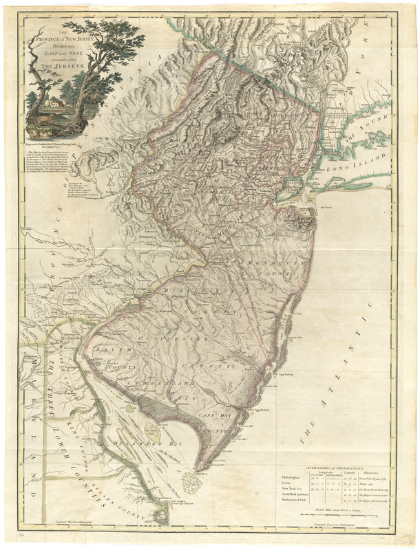
The province of New Jersey, divided into east and west, commonly called the Jerseys
This map is also available in American Revolutionary Geographies Online (ARGO), a collections portal especially built for material relating to the American Revolutionary War Era. Visit ARGO to learn more about this item and explore the historical geography of North America in the late eighteenth century.
Item Information
- Title:
- The province of New Jersey, divided into east and west, commonly called the Jerseys
- Description:
-
Bernard Ratzer, a Lieutenant in the Royal Artillery, prepared a survey of New Jersey in 1769 to assist the Boundary Commission in settling a long standing boundary dispute between the states of New York and New Jersey. London mapmaker William Faden published Ratzer's survey as a finished map in 1777 in his North American Atlas. Published during the American Revolution, the map depicts the area known to George Washington before the Battle of Monmouth, and shows the fortification at Valley Forge. Despite having several errors of location, the map is finely executed, and contains an elaborate cartouche of a farmhouse with landscape in the upper left corner. Displayed here is the first English edition of the map. A French derivative of this map by Georges-Louis LeRouge may be viewed online at: http://maps.bpl.org/id/rb15252.
- Creator:
- Faden, William, 1749-1836
- Contributor:
- Ratzer, Bernard
- Contributor:
- Bancker, Gerard, 1740-1799
- Name on Item:
-
engraved & published by Wm. Faden.
- Date:
-
1777
- Format:
-
Maps/Atlases
- Location:
- George Washington's Mount Vernon
- Collection (local):
-
Richard H. Brown Revolutionary War Map Collection at Mount Vernon
- Subjects:
-
New Jersey--Maps--Early works to 1800
New Jersey--Administrative and political divisions--Maps--Early works to 1800
- Places:
-
New Jersey
- Extent:
- 1 map : hand col. ; 77 x 55 cm.
- Terms of Use:
-
No known copyright restrictions.
This work is licensed for use under a Creative Commons Attribution Non-Commercial Share Alike License (CC BY-NC-SA).

- Publisher:
-
[London] :
Wm. Faden
- Scale:
-
Scale [ca. 1:420,000]
- Language:
-
English
- Catalog Record:
-
MVLA record
- Notes:
-
1st issue.
Prime meridian: Philadelphia.
Relief shown by hachures.
Shows county boundaries and "Division line run in 1743 between East New Jersey and West New Jersey."
"This map has been drawn from the survey made in 1769 ... by Bernard Ratzer ... and from another large survey of the northern parts ... by Gerard Banker."
Appears in William Faden's The North American atlas. 1777.
Includes table of "Astronomical observations."
Cataloging, conservation, and digitization made possible in part by The National Endowment for the Humanities: Exploring the human endeavor.
- Identifier:
-
06_01_008244
- LCCN:
-
74692203