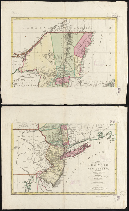
A map of the provinces of New-York and New Jersey, with a part of Pennsylvania and the Province of Quebec
This map is also available in American Revolutionary Geographies Online (ARGO), a collections portal especially built for material relating to the American Revolutionary War Era. Visit ARGO to learn more about this item and explore the historical geography of North America in the late eighteenth century.
Item Information
- Title:
- A map of the provinces of New-York and New Jersey, with a part of Pennsylvania and the Province of Quebec
- Creator:
- Sauthier, Claude Joseph
- Contributor:
- Lotter, Matthäus Albrecht, 1741-1810
- Name on Item:
-
from the topographical observations of C. J. Sauthier ; engraved and published by Matthew Albert Lotter
- Date:
-
1777
- Format:
-
Maps/Atlases
- Location:
-
Boston Public Library
Norman B. Leventhal Map & Education Center - Collection (local):
-
Norman B. Leventhal Map & Education Center Collection
- Subjects:
-
New York (State)--Maps--Early works to 1800
New York (State)--Administrative and political divisions--Maps--Early works to 1800
New Jersey--Maps--Early works to 1800
New Jersey--Administrative and political divisions--Maps--Early works to 1800
Northeastern States--Maps--Early works to 1800
Québec (Province)--Maps--Early works to 1800
- Places:
-
New York
New Jersey
- Extent:
- 1 map on 2 sheets : col. ; 76 x 57 cm, sheets 55 x 67 cm.
- Terms of Use:
-
No known copyright restrictions.
No known restrictions on use.
- Publisher:
-
Augsburg :
Matthew Albert Lotter
- Scale:
-
Scale ca. 1:1,040,000
- Language:
-
English
- Notes:
-
Prime meridian: New York.
Relief shown pictorially.
Shows administrative divisions in New York and New Jersey.
- Identifier:
-
06_01_006275
- Call #:
-
G3800 1777 .S28
- Barcode:
-
39999059022010


