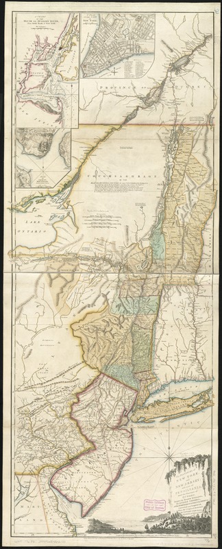
The provinces of New York and New Jersey : with part of Pensilvania, and the Province of Quebec
This map is also available in American Revolutionary Geographies Online (ARGO), a collections portal especially built for material relating to the American Revolutionary War Era. Visit ARGO to learn more about this item and explore the historical geography of North America in the late eighteenth century.
Item Information
- Title:
- The provinces of New York and New Jersey : with part of Pensilvania, and the Province of Quebec
- Title (alt.):
-
Scale ca. 1:650,000
- Description:
-
We Are One: Samuel Johannes Holland compiled the first map of New York published after the French and Indian War. Holland was a Dutch military engineer who became the Surveyor General for the Northern District in 1764. This map, first published in 1768, was based on maps and military surveys from the 1750s. The map was revised several times, resulting in this 1776 edition by Thomas Pownall, a Member of Parliament and former colonial administrator in New York and Massachusetts. The map’s vertical presentation and cartouche, which features an idyllic Hudson River scene, emphasizes the importance of the Hudson River-Lake Champlain corridor for fur trade with the Iroquois.
- Creator:
- Pownall, Thomas, 1722-1805
- Name on Item:
-
drawn by Major Holland, Surveyor General, of the Northern District in America. Corrected and improved, from the original materials, by Governr. Pownall, Member of Parliament, 1776.
- Date:
-
1776
- Format:
-
Maps/Atlases
- Location:
-
Boston Public Library
Norman B. Leventhal Map & Education Center - Collection (local):
-
Norman B. Leventhal Map & Education Center Collection
- Subjects:
-
United States--History--Revolution, 1775-1783--Maps--Early works to 1800
Northeastern States--Maps--Early works to 1800
New York (State)--Administrative and political divisions--Maps--Early works to 1800
New Jersey--Administrative and political divisions--Maps--Early works to 1800
Québec (Province)--Maps--Early works to 1800
New York (N.Y.)--Maps--Early works to 1800
Perth Amboy (N.J.)--Maps--Early works to 1800
- Places:
-
CanadaQuebec (province)
New YorkNew York
New JerseyMiddlesex (county)Perth Amboy
- Extent:
- 1 map : col. ; 134 x 55 cm.
- Terms of Use:
-
No known copyright restrictions.
No known restrictions on use.
- Publisher:
-
London :
Robt. Sayer & John Bennett
- Language:
-
English
- Notes:
-
Hand colored.
Relief shown pictorially.
Shows administrative divisions.
From Thomas Jeffery's American atlas. 1778.
Insets: A chart of the mouth of Hudson's River, from Sandy Hook to New York -- A plan of the city of New York --Plan of Amboy, with its environs, from an actual survey.
This map can be viewed as a georeferenced overlay in an interactive application made especially for We Are One: Mapping America's Road from Revolution to Independence http://d2o8owo4k087al.cloudfront.net/index.html?mapId=34.
- Notes (exhibitions):
-
Exhibited: "We Are One: Mapping America's Road from Revolution to Independence" organized by the Norman B. Leventhal Map Center at the Boston Public Library, 2015.
- Identifier:
-
06_01_003190
- Call #:
-
G3800 1776 .P6
- Barcode:
-
39999058999200
- LCCN:
-
74692227


