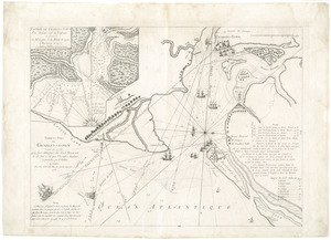
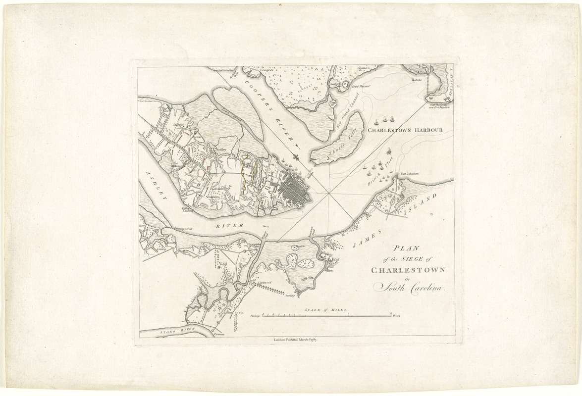
Plan of the siege of Charlestown in South Carolina
This map is also available in American Revolutionary Geographies Online (ARGO), a collections portal especially built for material relating to the American Revolutionary War Era. Visit ARGO to learn more about this item and explore the historical geography of North America in the late eighteenth century.
Item Information
- Title:
- Plan of the siege of Charlestown in South Carolina
- Description:
-
The plan displayed here depicts the Siege of Charleston, S.C., conducted by the British forces in early 1780. In February 1780, British General Henry Clinton's army arrived thirty miles south of Charleston, and began their assault on the city, which was protected by an American force commanded by Gen. Benjamin Lincoln. The British took control of the sea, and effectively cut the American off from any support. This plan was produced for Tarleton's memoir "A History of the Campaigns of 1780 and 1781, in the Southern Provinces of North America." The plan was produced on very heavy laid paper, and does not present any folds or pagination. This plan may be a pre-publication proof or a presentation copy.
- Creator:
- Tarleton, (Banastre), Lieutenant-General, 1754-1833
- Date:
-
1787
- Format:
-
Maps/Atlases
- Location:
- George Washington's Mount Vernon
- Collection (local):
-
Richard H. Brown Revolutionary War Map Collection at Mount Vernon
- Subjects:
-
Charleston (S.C.)--History--Siege, 1780--Maps--Early works to 1800
Charleston (S.C.)--History--Revolution, 1775-1783--Maps--Early works to 1800
- Places:
-
Charleston (county)Charleston
- Extent:
- 1 map : hand col. ; 26 x 30 cm. on sheet 37 x 54 cm.
- Terms of Use:
-
No known copyright restrictions.
This work is licensed for use under a Creative Commons Attribution Non-Commercial Share Alike License (CC BY-NC-SA).

- Publisher:
-
London :
[s.n.]
- Scale:
-
Scale [ca. 1:40,000]
- Language:
-
English
- Catalog Record:
-
MVLA record
- Notes:
-
Oriented with north to the upper left.
Relief shown by hachures.
Map published separately but identical to that appearing opposite p. 32 in Tarleton's History of the campaigns of 1780 and 1781 in the southern provinces of North America.
Map appearing in Tarleton described in Phillips. List of maps of America in the Library of Congress, p. 223 and in Nebenzahl, K. Bibliography of printed battle plans of the American Revolution 1775-1795, 83.
- Identifier:
-
06_01_008153