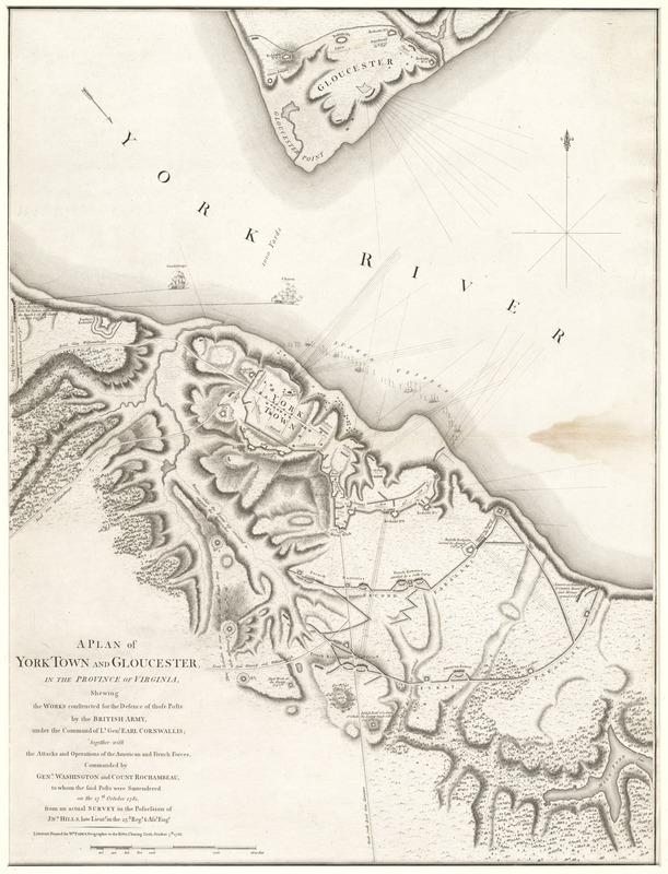
A plan of York Town and Gloucester, in the province of Virginia, shewing the works constructed for the defence of those posts by the British army, under the command of Lt. Genl. Earl Cornwallis, together with the attacks and operations of the American and French forces, commanded by Genl. Washington and Count Rochambeau, to whom the posts were surrendered on the 17th October 1781
This map is also available in American Revolutionary Geographies Online (ARGO), a collections portal especially built for material relating to the American Revolutionary War Era. Visit ARGO to learn more about this item and explore the historical geography of North America in the late eighteenth century.
Item Information
- Title:
- A plan of York Town and Gloucester, in the province of Virginia, shewing the works constructed for the defence of those posts by the British army, under the command of Lt. Genl. Earl Cornwallis, together with the attacks and operations of the American and French forces, commanded by Genl. Washington and Count Rochambeau, to whom the posts were surrendered on the 17th October 1781
- Creator:
- Hills, John, surveyor
- Publisher:
- Faden, William, 1749-1836
- Name on Item:
-
from an actual survey in the possession of Jn.o Hills, late Lieutt. in the 23rd Regt. & Asst. Engr.
- Date:
-
1785
- Format:
-
Maps/Atlases
- Location:
- George Washington's Mount Vernon
- Collection (local):
-
Richard H. Brown Revolutionary War Map Collection at Mount Vernon
- Subjects:
-
Yorktown (Va.)--History--Siege, 1781--Maps
Gloucester (Va.)--History--18th century--Maps
Cornwallis, Charles Cornwallis, Marquis, 1738-1805
Washington, George, 1732-1799
Rochambeau, Jean-Baptiste-Donatien de Vimeur, comte de, 1725-1807
- Places:
-
Gloucester (county)Gloucester
York (county)Yorktown
- Extent:
- 1 map ; 71 x 54 cm.
- Terms of Use:
-
No known copyright restrictions.
This work is licensed for use under a Creative Commons Attribution Non-Commercial Share Alike License (CC BY-NC-SA).

- Publisher:
-
London :
Wm. Faden
- Scale:
-
Scale [ca.1:5,750]
- Language:
-
English
- Catalog Record:
-
MVLA record
- Notes:
-
Shows fortifications, troop locations, and ships on the York River.
Relief shown by hachures.
- Identifier:
-
06_01_009558

![[Plan de defense de New-Port]](https://bpldcassets.blob.core.windows.net/derivatives/images/commonwealth:z603vn044/image_thumbnail_300.jpg)
 IIIF Manifest