Toggle navigation
LMEC Home
Exhibitions
Georeferencing
Tools for Teachers
Collections
My Favorites
Sign Up / Log In
Search
Search the map portal
Map Collection
Map Collection
Map Sets
Search
Search
Search for
Search In
All Fields
Creator
Title
Subject
Place
Search All Digital Collections
Advanced Search
165 Results
My Search
Start Over
More Like
commonwealth:j3865883p
Remove constraint More Like: commonwealth:j3865883p
Filter your Search
Place
North and Central America
141
United States
134
Massachusetts
109
Middlesex (county)
17
Caribbean Sea
14
West Indies
14
Bristol (county)
9
Atlantic Ocean
8
more
Place
»
Topic
Massachusetts--Maps
19
Caribbean Area--Maps
14
West Indies--Maps
14
Atlantic Coast (U.S.)--Maps
6
North Atlantic Ocean--Maps
6
North Atlantic Ocean--Navigation
6
Dedham (Mass.)--Maps
4
Election districts--Massachusetts--Maps
4
more
Topic
»
Date
Date range begin
–
Date range end
Current results range from
1758
to
2010
View distribution
Creator
Applied Geographics, Inc.
61
MassGIS (Office : Mass.)
56
Massachusetts. Executive Office of Environmental Affairs
32
Geological Survey (U.S.)
9
Massachusetts Bays Program
8
Massachusetts Coastal Zone Management Office
8
National Ocean Survey
6
Massachusetts. Department of Environmental Protection
4
more
Creator
»
Format
Maps/Atlases
164
Ephemera
1
Georeferenced
Yes
9
No
156
Collection
Norman B. Leventhal Map & Education Center Collection
159
Applied Geographics, Inc. Records
143
Boston and New England Maps
117
Urban Maps
28
Maritime Charts and Atlases
20
American Antiquarian Society Collection
6
American Revolutionary War-Era Maps
6
Available to use
No known restrictions
158
Search Constraints
Sort by relevance
relevance
title
date (asc)
date (desc)
Number of results to display per page
20 per page
10
per page
20
per page
50
per page
100
per page
View results as:
grid view
map view
Search Results
1.
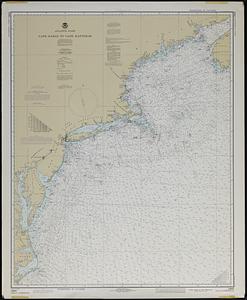
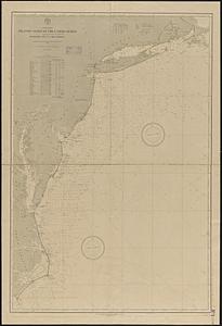
Atlantic coast, Cape Sable to Cape Hatteras
2.
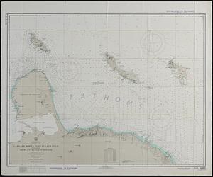
North Atlantic Ocean, West Indies
3.
South America, Caribbean Sea, Venezuela--Netherlands West Indies, Cabo San Román to Punta San Juan including Aruba, Curaçao,...
4.
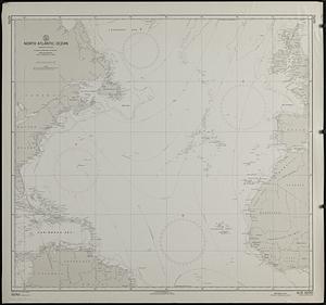
North Atlantic Ocean : compiled from various sources
5.
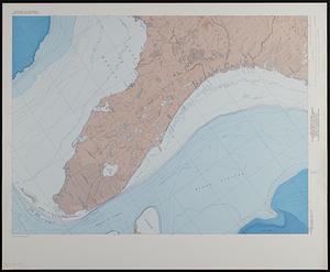
Map showing relation of land and submarine topography, Nova Scotia to Florida
6.
British Isles
7.
North Atlantic Ocean, eastern portion
8.
North Atlantic Ocean, southeast coast of North America, including the Bahamas and Greater Antilles
9.
Coast of North America from Point Judith to St. Antonio, (island of Cuba) including the Bahama Banks
10.
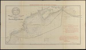
Map showing the Mackay-Bennett cables in the vicinity of the principal fishing grounds
11.
North America, Atlantic coast of the United States, Buzzard's Bay to Cape Lookout : compiled from the latest United States...
12.
Via RCA : a direct marine radio service to and from ships at sea
13.
An accurate map of the West Indies, : containing the Bahama & Carribe islands, the Great & Little Antilles, with the Leward and...
14.
An Accurate map of the West Indies, with the adjacent coast
15.
The countries of the Caribbean : including Mexico, Central America, the West Indies and the Panama Canal
16.
Dagbladets kart over krigsskuepladsen
17.
The Evening Post map of the West Indies
18.
Gulf of Mexico, West Indies and Caribbean Sea : from the most recent U.S. Coast Survey, Spanish and British Admiralty charts
19.
Les Isles Antilles et le Golfe du Méxique
20.
Map of Central America, Cuba, Porto Rico, and the islands of the Caribbean Sea
‹ Prev
Next ›
1
2
3
4
5
…
8
9