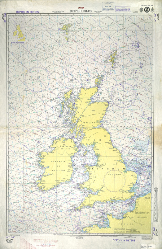
British Isles
Item Information
- Title:
- British Isles
- Description:
-
This modern navigational chart serves as a reminder that England is an island nation off the coast of Europe and that seafaring was an important activity in its history, especially since the late 16th century. Through its maritime and trading activities, England built a colonial empire around the world that included portions of North America and the Caribbean. As a modern navigational aid, this chart focuses on depth soundings in the coastal areas and surrounding seas, while the interior areas of the British Isles are left relatively blank, in stark contrast to the modern tourist map of Britain.
- Creator:
- Great Britain. Hydrographic Dept
- Publisher:
- United States. Defense Mapping Agency. Hydrographic/Topographic Center
- Name on Item:
-
Great Britain Hydrographic Dept.
- Date:
-
1985
- Format:
-
Maps/Atlases
- Location:
-
Boston Public Library
Norman B. Leventhal Map & Education Center - Collection (local):
-
Norman B. Leventhal Map & Education Center Collection
- Subjects:
-
Nautical charts--Atlantic Coast (British Isles)
Atlantic Coast (British Isles)--Maps
North Atlantic Ocean--Navigation
North Atlantic Ocean--Maps
- Places:
-
British Isles (area)
Atlantic Ocean
- Extent:
- 1 map : color ; 73 x 59 cm
- Terms of Use:
-
No known copyright restrictions.
No known restrictions on use.
- Publisher:
-
Washington, D.C. :
Defense Mapping Agency, Hydrographic/Topographic Center
- Scale:
-
Scale 1:500,000 at lat. 60⁰00ʹ
- Projection:
- Mercator proj.
- Language:
-
English
- Notes:
-
OMEGA.
Depths shown by isolines and soundings.
Relief shown by spot heights.
"Modified reproduction of INT 160, originally published December 9, 1983 by the United Kingdom. Crown copyright 1983."
"Depths in meters."
[Coastal chart] "35000."
Inset: 1985 magnetic variation curves in purple.
- Notes (exhibitions):
-
Exhibited: "Faces & Places" organized by the Norman B. Leventhal Map Center at the Boston Public Library, 2003-2004.
- Identifier:
-
05_04_000132
- Barcode:
-
30000007463665