Toggle navigation
LMEC Home
Exhibitions
Georeferencing
Tools for Teachers
Collections
My Favorites
Sign Up / Log In
Search
Search the map portal
Map Collection
Map Collection
Map Sets
Search
Search
Search for
Search In
All Fields
Creator
Title
Subject
Place
Search All Digital Collections
Advanced Search
8720 Results
My Search
Start Over
More Like
commonwealth:2514p078d
Remove constraint More Like: commonwealth:2514p078d
Filter your Search
Place
North and Central America
5,927
United States
4,844
Massachusetts
2,079
Europe
1,396
Suffolk (county)
1,046
Boston
1,019
Canada
449
Asia
439
more
Place
»
Topic
Boston (Mass.)--Maps
586
United States--Maps
282
Real property--Massachusetts--Boston--Maps
175
Massachusetts--Maps
162
Landowners--Massachusetts--Boston--Maps
133
North America--Maps--Early works to 1800
104
New England--Maps
102
Europe--Maps
79
more
Topic
»
Date
Date range begin
–
Date range end
Current results range from
1482
to
2023
View distribution
Creator
United States. Hydrographic Office
595
O.H. Bailey & Co
148
Des Barres, Joseph F. W. (Joseph Frederick Wallet), 1722-1824
123
United States. Post Office Dept
120
Ptolemy, 2nd cent
100
Walling, Henry Francis, 1825-1888
94
Geological Survey (U.S.)
86
Jefferys, Thomas, -1771
86
more
Creator
»
Format
Maps/Atlases
8,660
Manuscripts
215
Prints
56
Books
36
Objects/Artifacts
10
Drawings/Illustrations
8
Posters
5
Georeferenced
Yes
869
No
7,851
Collection
Norman B. Leventhal Map & Education Center Collection
8,697
Boston and New England Maps
2,233
Urban Maps
2,023
Maritime Charts and Atlases
1,083
American Revolutionary War-Era Maps
629
Boston Redevelopment Authority Collection
87
Sidney R. Knafel Map Collection at Phillips Academy
10
MacLean Collection Map Library
6
more
Collection
»
Available to use
No known restrictions
8,552
Creative Commons license
57
Search Constraints
Sort by relevance
relevance
title
date (asc)
date (desc)
Number of results to display per page
20 per page
10
per page
20
per page
50
per page
100
per page
View results as:
grid view
map view
Search Results
3781.
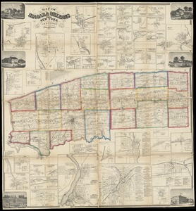
Map of Niagara and Orleans Counties, New York
3782.
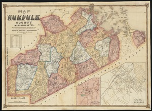
Map of Norfolk County, Massachusetts : based upon the trigonometrical survey of the state
3783.
Map of North America : showing all routes to Alaska and Klondike country
3784.
Map of North America
3785.
Map of North America : reduced from map on scale of 1:5,000,000
3786.
Map of North America
3787.
Map of North America : to illustrate facts of geographical distribution
3788.
A map of North America, & the West India Islands, with part of South America, Europe, Africa & the Atlantic Ocean with it's...
3789.
A map of North America, denoting the boundaries of the yearly meetings of Friends and the locations of the various Indian tribes
3790.
Map of North America showing the two lines of frontier as settled in October and November 1782 respectively by Mr. Oswald, the...
3791.
A map of North America, with the European settlements & whatever else is remarkable in ye West Indies, from the latest and best...
3792.
Map of North Carolina
3793.
Map of North Carolina
3794.
Map of north eastern China
3795.
Map of northern Georgia
3796.
Map of northern Luzon
3797.
Map of northern Luzon, showing a portion of the field of operations of the 8th Army Corps, Major General Elwell S. Otis commanding
3798.
Map of northern part of New York City
3799.
Map of Nova Scotia, or Acadia : with the islands of Cape Breton and St. John's, from actual surveys
3800.
Map of Oklahoma Territory
‹ Prev
Next ›
1
2
…
186
187
188
189
190
191
192
193
194
…
435
436