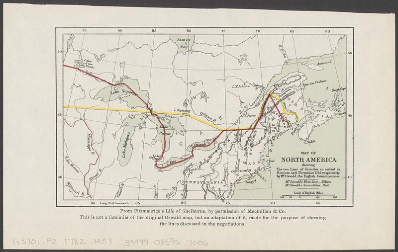
Map of North America showing the two lines of frontier as settled in October and November 1782 respectively by Mr. Oswald, the English commissioner
Item Information
- Title:
- Map of North America showing the two lines of frontier as settled in October and November 1782 respectively by Mr. Oswald, the English commissioner
- Contributor:
- Moore, John Bassett, 1860-1947
- Contributor:
- United States. Congress (53rd, 2nd session : 1893-1894). House
- Date:
-
[1898]
- Format:
-
Maps/Atlases
- Location:
-
Boston Public Library
Norman B. Leventhal Map & Education Center - Collection (local):
-
Norman B. Leventhal Map & Education Center Collection
- Subjects:
-
United States--Boundaries--Canada--Maps
Canada--Boundaries--United States--Maps
- Places:
-
United States
Canada
- Extent:
- 1 map : color ; 10 x 17 cm
- Terms of Use:
-
No known copyright restrictions.
No known restrictions on use.
- Publisher:
-
[Washington] :
[Government Printing Office]
- Scale:
-
Scale approximately 1:16,000,000
- Language:
-
English
- Notes:
-
Relief shown by hachures.
"From Fitzmaurice's Life of Shelburne, by permission of Macmillan & Co. This is not a facsimile of the original Oswald map, but an adaptation of it, made for the purpose of showing the lines discussed in the negotiations."
Detached from House of Representatives 53d congress, 2d session, mis. doc. no. 212. History and digest of the international arbitrations to which the United States has been a party volume I (Washington : Government Printing Office, 1898).
- Notes (date):
-
This date is inferred.
- Identifier:
-
06_01_018407
- Call #:
-
G3701.F2 1782 .M37
- Barcode:
-
39999085967006