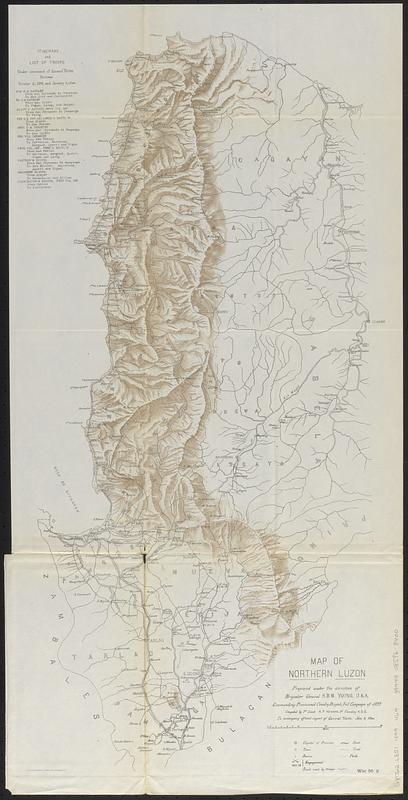
Map of northern Luzon
Item Information
- Title:
- Map of northern Luzon
- Cartographer:
- Howard, H. P.
- Contributor:
- Young, S. B. M. (Samuel Baldwin Marks), 1840-1924
- Contributor:
- United States. Congress (56th, 2nd session : 1900-1901). House
- Lithographer:
- Norris Peters Co.
- Name on Item:
-
prepared under the direction of Brig. Gen. S.B.M. Young, U.S.A. commanding provisional cavalry brigade, fall campaign of 1899 ; compiled by 1st Lieut. H.P. Howard, 3d Cavalry. A.D.C. to accompany official report of Gen. Young
- Date:
-
[1900]
- Format:
-
Maps/Atlases
- Genre:
-
Military maps
- Location:
-
Boston Public Library
Norman B. Leventhal Map & Education Center - Collection (local):
-
Norman B. Leventhal Map & Education Center Collection
- Subjects:
-
Luzon (Philippines)--History, Military--Maps
Philippines--History--Philippine American War, 1899-1902
Luzon (Philippines)--Maps
- Places:
-
PhilippinesLuzon (island)
- Extent:
- 1 map : color ; on sheet 75 x 38 cm
- Terms of Use:
-
No known copyright restrictions.
No known restrictions on use.
- Publisher:
-
[Washington, D.C.] :
[Government Printing Office]
- Scale:
-
Scale approximately 1:610,000
- Language:
-
English
- Notes:
-
Relief shown by shading.
"War 56 2."
Includes "Itinerary and list of troops under command of General Young between October 11, 1899, and January 5, 1900."
Map detached from a United States House of Representatives document in the United States congressional serial set (Serial Set 4075 H.doc.2/7): Annual Reports of the War Department for the fiscal year ended June 30, 1900. Report of the Lieutenant General Commanding the Army : in seven parts. Part 4. Washington : Government Printing Office, 1900.
- Notes (date):
-
This date is inferred.
- Identifier:
-
06_01_018444
- Call #:
-
G8062.L8S1 1899 .H69
- Barcode:
-
39999085968400