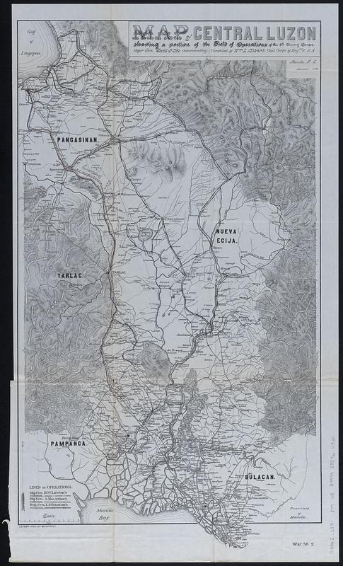
Map of central Luzon, showing a portion of the field of operations of the 8th Army Corps., Major Gen. Elwell S. Otis, commanding
Item Information
- Title:
- Map of central Luzon, showing a portion of the field of operations of the 8th Army Corps., Major Gen. Elwell S. Otis, commanding
- Description:
-
Map showing lines of operation of U.S. Army brigades led by generals Henry Ware Lawton, Arthur MacArthur, and Loyd Wheaton in the Philippines during the Philippine American War. Coverage area includes portions of Bulacan, Nueva Ecija, Pampanga, Pangasinan, and Tarlac provinces on the island of Luzon.
- Cartographer:
- United States. Army. Corps of Engineers
- Compiler:
- Siebert, William L.
- Lithographer:
- Andrew B. Graham Co.
- Name on Item:
-
compiled by Wm. L. Siebert, Capt. Corps of Engrs. U.S.A., Manila, P.I., November 1899
- Date:
-
[1900]
- Format:
-
Maps/Atlases
- Location:
-
Boston Public Library
Norman B. Leventhal Map & Education Center - Collection (local):
-
Norman B. Leventhal Map & Education Center Collection
- Subjects:
-
Philippines--History--Philippine American War, 1899-1902--Maps
Luzon (Philippines)--Maps
- Places:
-
PhilippinesLuzon (island)
- Extent:
- 1 map : color ; 67 x 38 cm
- Terms of Use:
-
No known copyright restrictions.
No known restrictions on use.
- Publisher:
-
[Washington, D.C.] :
[Government Printing Office]
- Scale:
-
Scale approximately 1:264,000
- Language:
-
English
- Notes:
-
Relief shown by hachures.
From Annual reports of the War Department for the fiscal year ended June 30, 1900. Report of the Lieutenant General commanding the army (Washington : Government Printing Office, 1900).
"War 56 2."
- Notes (date):
-
This date is inferred.
- Identifier:
-
06_01_018384
- Call #:
-
G8062.L8S1 1899 .U5
- Barcode:
-
39999085966834