Map of North America : to illustrate facts of geographical distribution
Item Information
- Title:
- Map of North America : to illustrate facts of geographical distribution
- Description:
-
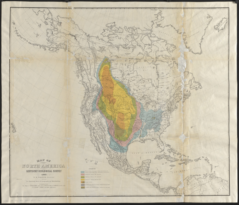
Shows the limit of range and restriction of bison americanus prior to 1800 and from 1800-1875, and locations where remains of bison antiquus and bison latifrons have been found.
America Transformed: This colorful map documents the diminishing range of bison during the 18th and 19th centuries. It accompanied an 1876 report prepared by Joel Allen, an American zoologist, mammalogist and ornithologist at Harvard's Museum of Comparative Zoology. The map shows the distribution of bison before 1800 (blue), 1825 (pink), 1850 (green), 1875 (yellow) and afterwards (orange). To emphasize the influence of migration and railroad construction on bison, the map also delineates the routes of the Emigrant Trail, the Union Pacific Railroad, and other railroads in Kansas and Colorado.
America Transformed: Viewpoint: This map only shows trail and railroad construction, but those were not the major reasons for the demise of bison in the 19th century. Bison leather was in high demand — it was used by the government to make Army boots, and bison-leather belts powered the machines that created the industrial revolution. The leftover bones were shipped east by the new railroads in massive amounts to be made into china. The demise of bison led to forced land cessions by Native people as many tribes lost their food supply and trusted the treaties' false promises of food and supplies. –Chris Newell (Passamaquoddy), endawnis Spears (Navajo, Ojibwe, Chickasaw, Choctaw), Dr. Jason Mancini Ph.D., Akomawt Educational Initiative
- Cartographer:
- Kentucky Geological Survey
- Colorist:
- Trouvelot, L.
- Lithographer:
- Meisel, A. (Augustus)
- Publisher:
- University Press (Cambridge, Mass.)
- Contributor:
- Allen, J. A. (Joel Asaph), 1838-1921
- Name on Item:
-
Kentucky Geological Survey ; compiled from the maps of Stieler's atlas, the isothermal maps of Schott, records of the U.S. Coast Survey and other authorities ; L. Trouvelot, artist
- Date:
-
[1876]
- Format:
-
Maps/Atlases
- Location:
-
Boston Public Library
Norman B. Leventhal Map & Education Center - Collection (local):
-
Norman B. Leventhal Map & Education Center Collection
- Subjects:
-
American bison--Maps
North America--Maps
- Places:
-
North America (area)
- Extent:
- 1 map : color ; 62 x 73 cm
- Terms of Use:
-
No known copyright restrictions.
No known restrictions on use.
- Publisher:
-
[Cambridge, Mass.] :
[University Press]
- Scale:
-
Scale approximately 1:14,000,000
- Language:
-
English
- Notes:
-
From: The American bisons, living and extinct / J.A. Allen. Cambridge, [Mass.] : University Press, 1876.
Relief shown by hachures.
Prime meridians: Ferro and Washington with reference to Greenwich.
Conserved in loving memory of Ruth Tietze Brown, February 3, 1908-November 16, 2017, in honor of her son Richard Brown.
- Notes (date):
-
This date is inferred.
- Notes (exhibitions):
-
Exhibited: "America Transformed. Part 2: Homesteads to Modern Cities," organized by the Norman B. Leventhal Map & Education Center at the Boston Public Library, 2019-2020.
- Identifier:
-
06_01_016350
- Call #:
-
G3301.D4 1876 .K46
- Barcode:
-
39999085945762


