Toggle navigation
LMEC Home
Exhibitions
Georeferencing
Tools for Teachers
Collections
My Favorites
Sign Up / Log In
Search
Search the map portal
Map Collection
Map Collection
Map Sets
Search
Search
Search for
Search In
All Fields
Creator
Title
Subject
Place
Search All Digital Collections
Advanced Search
82 Results
My Search
Start Over
Date
1835
Remove constraint Date: <span class='single'>1835</span>
Filter your Search
Place
North and Central America
43
United States
34
Boston
12
Suffolk (county)
12
Europe
9
Massachusetts
4
Michigan
4
North Korea
4
more
Place
»
Topic
Boston (Mass.)--Maps
9
Ohio--Boundaries--Michigan--Maps
6
Michigan--Boundaries--Ohio--Maps
5
Korea--Maps
4
China--Maps
3
Japan--Maps
3
Maryland--Maps
3
Rome (Italy)--Maps
3
more
Topic
»
Date
1835
[remove]
82
Date range begin
–
Date range end
Current results range from
1770
to
1990
1835
to
1835
82
Creator
Bradford, T. G. (Thomas Gamaliel), 1802-1887
4
Fuller, Stephen P.
3
Bonner, John, ca. 1643-1726
2
Hood, Washington
2
Hood, Washington.
2
Pendleton's Lithography
2
Talcott, Andrew, 1797-1883
2
United States. Army. Corps of Engineers
2
more
Creator
»
Format
Maps/Atlases
80
Manuscripts
12
Drawings/Illustrations
1
Objects/Artifacts
1
Prints
1
Georeferenced
Yes
9
No
73
Collection
Norman B. Leventhal Map Center Collection
64
Urban Maps
17
Boston and New England Maps
15
American Revolutionary War-Era Maps
12
Library of Congress Collection
5
MacLean Collection Map Library
4
Sidney R. Knafel Map Collection at Phillips Academy
3
Newberry Library Collection
2
more
Collection
»
Available to use
No known restrictions
66
Creative Commons license
6
Search Constraints
Sort by relevance
relevance
title
date (asc)
date (desc)
Number of results to display per page
100 per page
10
per page
20
per page
50
per page
100
per page
View results as:
grid view
map view
Search Results
1.
1. Prise de Newport par d'Estaing, 1778 : 2. Embossage de Ternay à Newport, 1780
2.
Afrika
3.
Afrique
4.
America settle
5.
Asia Florente Persarum Imperio
6.
Brazil, Bolivia, & Peru
7.
Carte itinéraire de l'Europe indiquant les limites actuelles des etats : dediée au Roi
8.
A chart of the gulf stream
9.
A comprehensive atlas geographical, historical & commercial [title page]
10.
Copy of an ancient plan belonging to the City (not dated probably about 1738)
11.
A diagram of the triangulation for the survey of the coast of the United States, made in 1817 and 1833, and the secondary...
12.
Dongguk yojido
13.
Geographisches lottospiel, ganz neue vermehrte u. verbesserte auflage : durch welches sich die kinder spielend neit den...
14.
Geological map of part of Jamaica
15.
Germania antiqua
16.
Haejwa do
17.
Insularum Japonicarum : tabulae geographicae secundum opus = Nippon jo tsi ro tei sen tsu
18.
Ireland, from the best authorities : with distances in miles from Dublin
19.
[Isthmus of Tehuantepec, Mexico]
20.
Joseon yojido
21.
The journey, or, cross roads to conqueror's castle : a new and interesting game
22.
[Manuscript map of coast from Maine to Delaware]
23.
Manuscript maps of U.S. states
24.
Manuscript maps of U.S. states, possibly drawn by a schoolchild
25.
Map exhibiting the country between Lakes Michigan and Erie, and the contested boundary lines
26.
Map, exhibiting the position of the several lines connected with the settlement of the Ohio boundary question
27.
Map of a part of west-Florida : overlay down
28.
Map of a part of west-Florida : overlay up
29.
A map of Berkshire County Mass
30.
Map of Mobile Bay
31.
Map of the British and French dominions in North America, drawn by order of the British government in 1755, showing what that...
32.
Map of the country embracing the several routes examined with a view to a national road from Washington to Lake Ontario
33.
Map of the Eastern Townships of Lower Canada
34.
A map of the extremity of Cape Cod : including the townships of Provincetown & Truro: with chart of their sea coast and of Cape...
35.
Map of the lands in Mississippi ceded by the Chickasaws to the United States in 1832 and 1834
36.
Map of the Southern provinces of the United States
37.
Map of the United States : intending chiefly to exhibit the post roads & distances
38.
A map of the Weald of Kent
39.
[Map of W. Dall's lots in Athens County, Washington County, and Gallia County, Ohio]
40.
Massachusetts
41.
Massachusetts
42.
National map of the United States
43.
Northern Africa
44.
Ohio boundary no. 1 South Bend of Lake Michigan : map, exhibiting the position occupied in the determination of the latitude of...
45.
Ohio boundary no. 1 South Bend of Lake Michigan : map, exhibiting the position occupied in the determination of the latitude of...
46.
Ohio boundary no. 2 : map exhibiting the positions occupied on the Maumee Bay and river: viz: Turtle Island, the North Cape,...
47.
Palestine or Canaan
48.
Physical map of Germany
49.
Pianta di Roma
50.
Pianta di Roma
51.
[Plan de defense de New-Port] : [dans l'Isle Rhode (Amerique Septentrionalle) par l'escadre du Roy aux ordres de Monsieur le...
52.
Plan de la ville d'Amsterdam
53.
Plan géométrique de la ville de Bruxelles
54.
A plan of Boston, from actual survey by Osgood Carleton
55.
Plan of Boston with parts of the adjacent towns
56.
Plan of Boston with parts of the adjacent towns
57.
Plan of building lots on Phillips Place, Tremont & Somerset Streets
58.
Plan of building lots on Phillips Place, Tremont & Somerset Streets
59.
Plan of Dean Danl Greens farm in Reading
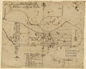
60.
Plan of Portland
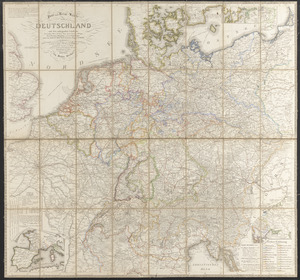
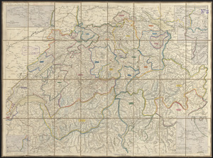
61.
Plan of Springfield
62.
Plan of the city of Boston
63.
Plan of the city of St. Louis
64.
Plan of the route of pipes from Jamaica Pond, in Roxbury to the reservoir, in Boston
65.
Post- und reise-karte von Deutschland und den anliegenden ländern bis London, Havre de Grace, Tours, Lyon, Genua, Bologna,...
66.
A reconnoissance of the Minnay Sotor Watapāh; or St. Peter's River to its sources : made in the year 1835
67.
Roma, la capitale degli Stati Pontifici, fondata da Romolo e Remo verso vanno 754 prima di Cristo, e situato sul 41°53'54" di...
68.
Schweiz
69.
[Sketch of the region of the island of Cape Breton, between the parallels of forty-five and forty-eight degrees of latitude]
70.
Solar and lunar eclipse diagrams
71.
South America
72.
South Cove, in Boston
73.
The South Cove territory, comprising every part which is coloured on this map
74.
Southern hemisphere
75.
This map of Kentucke
76.
This plan contains about 1000 acres, of the Canton Company's Land
77.
The tourist's pocket map of the state of Ohio : exhibiting its internal improvements, roads, distances &c
78.
The town of Boston in New England
79.
The town of Boston in New England
80.
Typo de la carta cosmographica de Gaspar Vopellio Medeburgense
81.
Vereinigte Staaten von Nord Amerika : ohne das West Gebiet der Union
82.
Yeojido