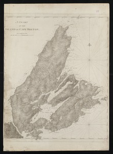
[Sketch of the region of the island of Cape Breton, between the parallels of forty-five and forty-eight degrees of latitude]
![[Sketch of the region of the island of Cape Breton, between the parallels of forty-five and forty-eight degrees of latitude]](https://bpldcassets.blob.core.windows.net/derivatives/images/commonwealth:4m90fh38k/image_access_800.jpg)
Item Information
- Title:
- [Sketch of the region of the island of Cape Breton, between the parallels of forty-five and forty-eight degrees of latitude]
- Text begins :
- Cape Breton Island
- Title (alt.) :
- A quarente lieuees [qt] la route est norouest
- Date:
-
[1800–1899]
- Format:
-
Maps/Atlases
- Location:
-
Boston Public Library
Norman B. Leventhal Map & Education Center - Collection (local):
-
Norman B. Leventhal Map & Education Center Collection
- Subjects:
-
Cape Breton Island (N.S.)--Maps--Early works to 1800
- Places:
-
CanadaNova Scotia (province)Cape Breton Island (island)
- Extent:
- 1 map ; 7 x 20 cm., on sheet 27 x 20 cm.
- Terms of Use:
-
No known copyright restrictions.
No known restrictions on use.
- Publisher:
-
S.l :
s.n.
- Scale:
-
Scale indeterminable
- Language:
-
French
- Notes:
-
Photocopy of a page of text with a ms. map; original in the Bibliotheque Nationale.
Title and description of photocopy written on verso by a cataloger.
Ms. text below the sketch.
- Notes (date):
-
This date is inferred.
- Identifier:
-
06_01_011723
- Call #:
-
G3422.C29 1600 .S54 1800
- Barcode:
-
39999065688218