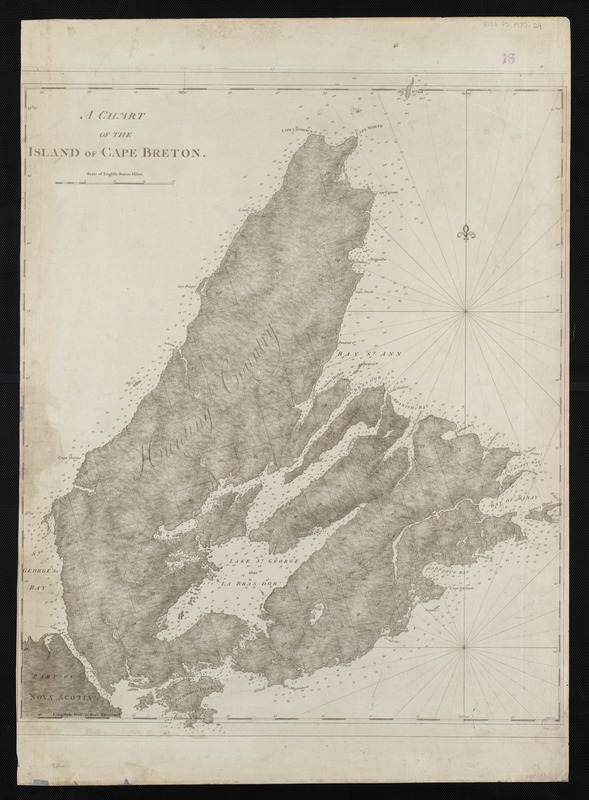
A chart of the island of Cape Breton
This map is also available in American Revolutionary Geographies Online (ARGO), a collections portal especially built for material relating to the American Revolutionary War Era. Visit ARGO to learn more about this item and explore the historical geography of North America in the late eighteenth century.
Item Information
- Title:
- A chart of the island of Cape Breton
- Description:
-
Samuel Holland's topographic surveys and Des Barres' hydrographic soundings appear on this chart of Cape Breton Island, which was included in The Atlantic Neptune. Since the British knew relatively little about the interior of the island, surveying proved to be more difficult for Holland than on St. John's Island. The northwest region of the island was simply referred to as "Hunting Country." As on St. John Island, Holland divided the land and named places in a similar manner. However, because English royal names never became part of the local vernacular, these place names reverted to French, or were named anew by subsequent Scottish settlers.
- Creator:
- Des Barres, Joseph F. W. (Joseph Frederick Wallet), 1722-1824
- Date:
-
[1781]
- Format:
-
Maps/Atlases
- Location:
-
Boston Public Library
Norman B. Leventhal Map & Education Center - Collection (local):
-
Norman B. Leventhal Map & Education Center Collection
- Subjects:
-
Nautical charts--Nova Scotia--Cape Breton Island--Early works to 1800
Cape Breton Island (N.S.)--Maps--Early works to 1800
- Places:
-
CanadaNova Scotia (province)Cape Breton Island (island)
- Extent:
- 1 chart ; 71 x 57 cm.
- Terms of Use:
-
No known copyright restrictions.
No known restrictions on use.
- Publisher:
-
London :
J.F.W. Des Barres
- Scale:
-
Scale [ca. 1:275,000]
- Language:
-
English
- Notes:
-
Relief shown by hachures and shading. Depths shown by soundings.
Appears in the author's Atlantic Neptune. London : J.F.W. Des Barres, 1777-[1781].
- Notes (date):
-
This date is inferred.
- Notes (exhibitions):
-
Exhibited: "Charting an Empire: The Atlantic Neptune" organized by the Norman B. Leventhal Map Center at the Boston Public Library, 2013.
- Identifier:
-
06_01_004961
- Call #:
-
G1106.P5 D47 1777
- Barcode:
-
30000003804840