Toggle navigation
LMEC Home
Exhibitions
Georeferencing
Tools for Teachers
Collections
My Favorites
Sign Up / Log In
Search
Search the map portal
Map Collection
Map Collection
Map Sets
Search
Search
Search for
Search In
All Fields
Creator
Title
Subject
Place
Search All Digital Collections
Advanced Search
14021 Results
Filter your Search
Place
North and Central America
10,683
United States
8,692
Massachusetts
2,808
Suffolk (county)
1,682
Boston
1,638
Europe
1,420
Canada
1,009
New York
674
more
Place
»
Topic
Boston (Mass.)--Maps
748
City planning--Massachusetts--Boston--Maps
418
United States--History--Revolution, 1775-1783--Maps
331
United States--Maps
328
Real property--Massachusetts--Boston--Maps
254
Urban renewal--Massachusetts--Boston--Maps
254
North America--Maps--Early works to 1800
240
Massachusetts--Maps
234
more
Topic
»
Date
Date range begin
–
Date range end
Current results range from
1482
to
2023
View distribution
Creator
United States. Hydrographic Office
597
Boston Redevelopment Authority
404
Des Barres, Joseph F. W. (Joseph Frederick Wallet), 1722-1824
247
Jefferys, Thomas, -1771
172
Royal United Services Institute for Defence and Security Studies
160
George, III, King of Great Britain, 1738-1820
152
George, IV, King of Great Britain, 1762-1830
151
O.H. Bailey & Co
148
more
Creator
»
Format
Maps/Atlases
13,839
Manuscripts
985
Prints
102
Books
49
Drawings/Illustrations
44
Photographs
15
Objects/Artifacts
13
Documents
7
more
Format
»
Georeferenced
Yes
979
No
13,042
Collection
Norman B. Leventhal Map & Education Center Collection
9,110
American Revolutionary War-Era Maps
3,627
Boston and New England Maps
2,921
Urban Maps
2,480
Maritime Charts and Atlases
1,169
William L. Clements Library Collection
910
Library of Congress Collection
618
Boston Redevelopment Authority Collection
475
more
Collection
»
Available to use
No known restrictions
10,268
Creative Commons license
1,678
Search Constraints
Sort by relevance
relevance
title
date (asc)
date (desc)
Number of results to display per page
20 per page
10
per page
20
per page
50
per page
100
per page
View results as:
grid view
map view
Search Results
8781.
Plan de la ville, port, et rade de Newport : avec une partie de Rhode-Island occupée par l'armée française aux ordres de Mr....
8782.
Plan de la ville, rade, et environs de Newport en Rode Island, avec le campement de l'armée Françoise prés de cette place en...
8783.
Plan de l'affaire de Westfield & du camp de Raway
8784.
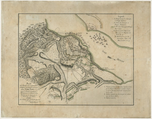
Plan de l'armée de Cornwallis attaquée et faitte prisoniere dans York Town : le 19 8bre par l'armée combinée Francaise et...
8785.
Plan de l'attaque de Porto Bello par l'Amiral Vernon
8786.
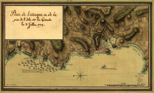
Plan de l'attaque et de la prise de l'isle de la Grenade le 3 juillet 1779
8787.
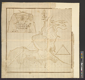
Plan de l'entrée de la rivière de Charleston le 30 Dexbre 1776
8788.
Plan de l'Habitation de Monsieur de La Porte-Lalanne Située au Quartier du Cul-de-Sac Dépendence du Port-au-Prince : en l'Etat...
8789.
Plan de l'habitation de Sr. Fleuriau depuis 1743 qu'il a commencé a l'établir, jusq'en 1749 ... suivant le nouveau plan tiré...
8790.
Plan de l'ile d'Amelia a la cote de la Floride orientale
8791.
PLAN DE L'INTENDANCE DE QUE'BEC : Cette Maison Sert aussi de Palais; Elle est Située hors de la Ville, dans le Faubourg de...
8792.
Plan de l'isle de la Grenade : ou sont marqués dans leur juste position, les ports et mouillages, les ville et bourgs, les...
8793.
Plan de l'Isle de Martinique
8794.
Plan de l'isthme de Suez, de Port-Said, Ismailia et Suez pour servir d'annexe au guide général d'Egypte
8795.
[Plan de Louisburgh, et partie de la baye de Gabarus]
8796.
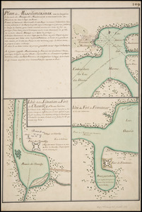
Plan de Missilimakinak avec la description de la route du Missisipi ; Idée de la situation du fort de Chambly, et des ses...
8797.
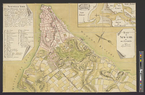
Plan de New-York et des environs
8798.
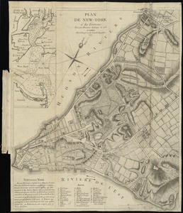
Plan de New-York et des environs
8799.
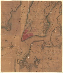
Plan de New-York et des îles environnantes
8800.
Plan de New-York et les environs
‹ Prev
Next ›
1
2
…
436
437
438
439
440
441
442
443
444
…
701
702

![[Plan de Louisburgh, et partie de la baye de Gabarus]](https://bpldcassets.blob.core.windows.net/derivatives/images/commonwealth:hx11z045s/image_thumbnail_300.jpg)