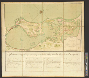
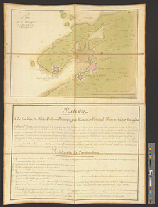
Plan de l'attaque de Porto Bello par l'Amiral Vernon
This map is also available in American Revolutionary Geographies Online (ARGO), a collections portal especially built for material relating to the American Revolutionary War Era. Visit ARGO to learn more about this item and explore the historical geography of North America in the late eighteenth century.
Item Information
- Title:
- Plan de l'attaque de Porto Bello par l'Amiral Vernon
- Title (alt.):
-
No. 125 manuscrit plan de l'attaque de Porto Bello par l'Amiral Vernon 1739 en Amérique lavée
- Date:
-
[ca. 1741]
- Format:
-
Maps/Atlases
- Genre:
-
Manuscript maps
- Location:
- William L. Clements Library
- Collection (local):
-
William L. Clements Library Collection
- Subjects:
-
Anglo-Spanish War, 1739-1748--Maps
Portobelo (Panama)--Maps
Vernon, Edward, 1684-1757
- Places:
-
PanamaColón (province)Portobelo
- Extent:
- 1 ms. map : col. ; 74.5 x 47.8 cm
- Terms of Use:
-
The University of Michigan Library provides access to these materials for educational and research purposes. These materials may be under copyright. If you decide to use any of these materials, you are responsible for making your own legal assessment and securing any necessary permission. If you have questions about the collection, please contact the William L. Clements Library.
Contact host institution for more information.
- Scale:
-
Scale 1:31,000.
- Language:
-
French
- Catalog Record:
-
Catalog record
- Notes:
-
Shows Vernon's 1739 attack on Portobelo.
Below map is account of Vernon's attack and copy of the articles of capitulation.
Map sectioned and mounted on orange linen.
- Identifier:
-
7485
- Barcode:
-
B1937352