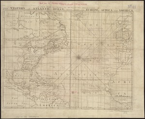
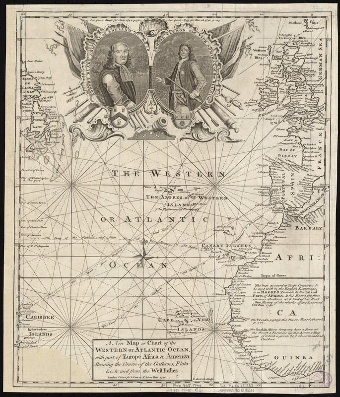
A new map or chart of the Western or Atlantic Ocean, with part of Europe Africa & America : showing the course of galleons, flota &c. to and from the West Indies
This map is also available in American Revolutionary Geographies Online (ARGO), a collections portal especially built for material relating to the American Revolutionary War Era. Visit ARGO to learn more about this item and explore the historical geography of North America in the late eighteenth century.
Item Information
- Title:
- A new map or chart of the Western or Atlantic Ocean, with part of Europe Africa & America : showing the course of galleons, flota &c. to and from the West Indies
- Creator:
- Bowen, Emanuel, d. 1767
- Name on Item:
-
E. Bowen sculp.
- Date:
-
1740
- Format:
-
Maps/Atlases
- Location:
-
Boston Public Library
Norman B. Leventhal Map & Education Center - Collection (local):
-
Norman B. Leventhal Map & Education Center Collection
- Subjects:
-
North Atlantic Ocean--Maps--Early works to 1800
Atlantic Ocean--Maps--Early works to 1800
Blake, Robert, 1599-1657
Vernon, Edward, 1684-1757
- Places:
-
Atlantic Ocean
- Extent:
- 1 map ; 35 x 29 cm.
- Terms of Use:
-
No known copyright restrictions.
No known restrictions on use.
- Publisher:
-
London :
Printed for E. Cave
- Scale:
-
Scale [ca. 1:1,800,000]
- Language:
-
English
- Notes:
-
Shows North Atlantic Ocean with ship routes to Spain and England from Latin America.
Depths shown by shading.
Appears in the Gentlemen's Magazine. London. Vol. 10, 1740.
Includes cartouche with portraits: "Robert Blake Admiral of England &c. 1650" and "Edward Vernon Esqr. Vice Admiral of the Blue 1740."
Cataloging, conservation, and digitization made possible in part by The National Endowment for the Humanities: Exploring the human endeavor.
- Identifier:
-
E. Cave at St. Johns Gate, London
- Call #:
-
G9110 1740 .B6
- Barcode:
-
39999059030211