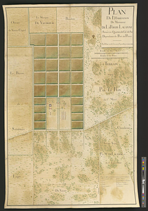
Plan de l'habitation de Sr. Fleuriau depuis 1743 qu'il a commencé a l'établir, jusq'en 1749 ... suivant le nouveau plan tiré par Mr. Delagrené en 1753 ...
This map is also available in American Revolutionary Geographies Online (ARGO), a collections portal especially built for material relating to the American Revolutionary War Era. Visit ARGO to learn more about this item and explore the historical geography of North America in the late eighteenth century.
Item Information
- Title:
- Plan de l'habitation de Sr. Fleuriau depuis 1743 qu'il a commencé a l'établir, jusq'en 1749 ... suivant le nouveau plan tiré par Mr. Delagrené en 1753 ...
- Contributor:
- Langrené, Jean-Claude de
- Contributor:
- Fleuriau, Aimé-Benjamin
- Date:
-
[ca. 1753]
- Format:
-
Maps/Atlases
- Genre:
-
Manuscript maps
- Location:
- William L. Clements Library
- Collection (local):
-
William L. Clements Library Collection
- Subjects:
-
Real property--Haiti--Croix des Bouquets--Maps
Plantations--Haiti--Maps
Slavery--Haiti--Maps
Croix des Bouquets (Haiti)--Maps
- Places:
-
HaitiDépartement de l’Ouest
Croix-des-Bouquets
- Extent:
- 1 ms. map : col. ; 53 x 71.8 cm.
- Terms of Use:
-
The University of Michigan Library provides access to these materials for educational and research purposes. These materials may be under copyright. If you decide to use any of these materials, you are responsible for making your own legal assessment and securing any necessary permission. If you have questions about the collection, please contact the William L. Clements Library.
Contact host institution for more information.
- Scale:
-
Scale indeterminable.
- Language:
-
French
- Catalog Record:
-
Catalog record
- Notes:
-
Colored pen and ink plan of plantation owned by Aimé-Benjamin Fleuriau, in or near Croix-des-Bouquets, Saint-Domingue.
Shows main house and outbuildings, crop fields, irrigation canals, and roads.
Relief shown pictorially.
Includes two penciled-in parallel rows of rectangular outbuildings, adjacent to the main buildings, possibly slave quarters.
- Identifier:
-
891
- Barcode:
-
B6115169