Toggle navigation
LMEC Home
Exhibitions
Georeferencing
Tools for Teachers
Collections
My Favorites
Sign Up / Log In
Search
Search the map portal
Map Collection
Map Collection
Map Sets
Search
Search
Search for
Search In
All Fields
Creator
Title
Subject
Place
Search All Digital Collections
Advanced Search
2843 Results
My Search
Start Over
atlas
Remove constraint atlas
Filter your Search
Place
North and Central America
1,401
United States
829
Europe
351
Canada
271
Suffolk (county)
163
Boston
157
Asia
136
South America
101
more
Place
»
Topic
Landowners--Massachusetts--Boston--Maps
115
Real property--Massachusetts--Boston--Maps
106
United States--Maps
87
Boston (Mass.)--Maps
63
United States--History--French and Indian War, 1754-1763--Maps
63
Saint Lawrence River--Maps
41
Nautical charts--Early works to 1800
39
North America--Maps--Early works to 1800
36
more
Topic
»
Date
Date range begin
–
Date range end
Current results range from
1482
to
2023
View distribution
Creator
United States. Hydrographic Office
582
Des Barres, Joseph F. W. (Joseph Frederick Wallet), 1722-1824
118
Ptolemy, 2nd cent
100
Bromley, George Washington
99
Bromley, Walter Scott
97
G.W. Bromley & Co.
75
Carey, Mathew, 1760-1839
74
Paullin, Charles Oscar, 1868 or 1869-1944
70
more
Creator
»
Format
Maps/Atlases
2,827
Manuscripts
58
Books
37
Prints
8
Documents
5
Drawings/Illustrations
1
Georeferenced
Yes
142
No
2,701
Collection
Norman B. Leventhal Map Center Collection
2,386
Maritime Charts and Atlases
1,150
American Revolutionary War-Era Maps
504
Boston and New England Maps
374
Urban Maps
250
Massachusetts Real Estate Atlases
144
William L. Clements Library Collection
92
Mapping Boston Collection
61
more
Collection
»
Available to use
No known restrictions
2,292
Creative Commons license
158
Search Constraints
Sort by relevance
relevance
title
date (asc)
date (desc)
Number of results to display per page
50 per page
10
per page
20
per page
50
per page
100
per page
View results as:
grid view
map view
Search Results
2151.
A new mapp of the island of St. Christophers
2152.
[North east coast of Nova Scotia and Northumberland Strait]
2153.
[North east coast of Nova Scotia and Northumberland Strait]
2154.
North view of Pensacola, on the island of Santa Rosa ; Plan of the harbour and settlement of Pensacola
2155.
Païs cedés, sheet IId, containing the Peninsula & Gulf of Florida, with the Bahama Islands
2156.
Païs cedés, sheet Ist, containing the coast of Louisiana and Florida
2157.
Part of New England
2158.
Particular draughts and plans of some of the principal towns and harbours belonging to the English, French, and Spaniards, in...
2159.
Plan de la rivière du Cap Fear depuis la barre jusques à Brunswick
2160.
Plan de Puerto de Mariel
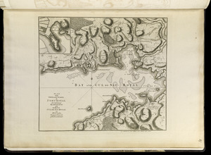
2161.
Plan of Bahía Honda ; Plan of Puerto de Cavañas
2162.
Plan of Bahia Xagua on the south side of Cuba ; Plan of the Colorado Rocks, near the west end of Cuba
2163.
Plan of La Vera Cruz, from Spanish draughts ; Plan of Port Royal Laguna, commonly called Logwood Creeks
2164.
A plan of Port Royal in South Carolina
2165.
A plan of Quebec and environs, with its defences and the occasional entrenched camps of the French commanded by Marquis de...
2166.
Plan of the city and harbour of the Havana ; Plan of Bahia de Matanzas
2167.
Plan of the harbour of San Fernando de Omoa ; A map of the Isthmus of Panama, drawn from Spanish surveys
2168.
A plan of the river and sound of D'Awfoskee in South Carolina
2169.
Plan of the town and citadel of Fort Royal, the capital of Martinico : with the Bay of Cul de Sac Royal
2170.
Plan of the town and fort of Grenada
2171.
Plan of the town and harbour of San Juan de Puerto Rico ; Plan of the Aguada Nueva de Puerto Rico
2172.
A plan of the town of Newport in the province of Rhode Island
2173.
A plan of the town of Newport in the province of Rhode Island
2174.
Plan of the town, road, and harbour of Chagre ; Plan of Porto Belo
2175.
Plan of Zisapata Bay ; Plan of the harbour of Carthagena
2176.
Port Amherst ... : Port Haldimand
2177.
Port Campbell
2178.
Port Hood, situated on the north-western extremity of the island of Cape Breton
2179.
Port Jackson
2180.
Port Mills : Port Mansfield ; Gambier Harbour
2181.
Port Mills : Port Mansfield ; Gambier Harbour
2182.
Port Royal in South Carolina : taken from surveys deposited at the Plantation Office
2183.
[Port Shediack and Cocagne]
2184.
Preliminary sketch showing the positions of Davis's Shoal and other dangers recently discovered by the Coast Survey and the...
2185.
Provincetown Harbor
2186.
The River St. John
2187.
Sandwich Bay ... low water
2188.
The south east coast of Cape Breton Island
2189.
The south east coast of the island of St. John : surveyed under the direction of the Right Honourable the Lords of Trade and...
2190.
[Southwest coast of Nova Scotia from Cape Sable to Cape St. Mary]
2191.
Spry Harbour : Port Pallisser ; Port North ; Port Parker ; Beaver Harbour ; Fleming River
2192.
[St. Peter's Bay, on the south shore of Cape Breton Island]
2193.
A survey of the coast about Cape Lookout in North Carolina, taken the 29th. of June 1756
2194.
[The south east coast of the island of St. John]
2195.
This harbour of Boston
2196.
[Torbay]
2197.
A view from the south eastward of Halifax Harbor : Appearance of the shore, (at three miles off,) four or five leagues to the...
2198.
A view of Boston
2199.
View of Cape Egmont and winter Rock from the eastward : Entrance of Egmont Harbor ; The entrance of Keppel Harbor, 10 leagues...
2200.
A view of Port Hood, sailing into the harbor : A view of the Plaister Cliffs, in George's Bay
‹ Prev
Next ›
1
2
…
40
41
42
43
44
45
46
47
48
…
56
57