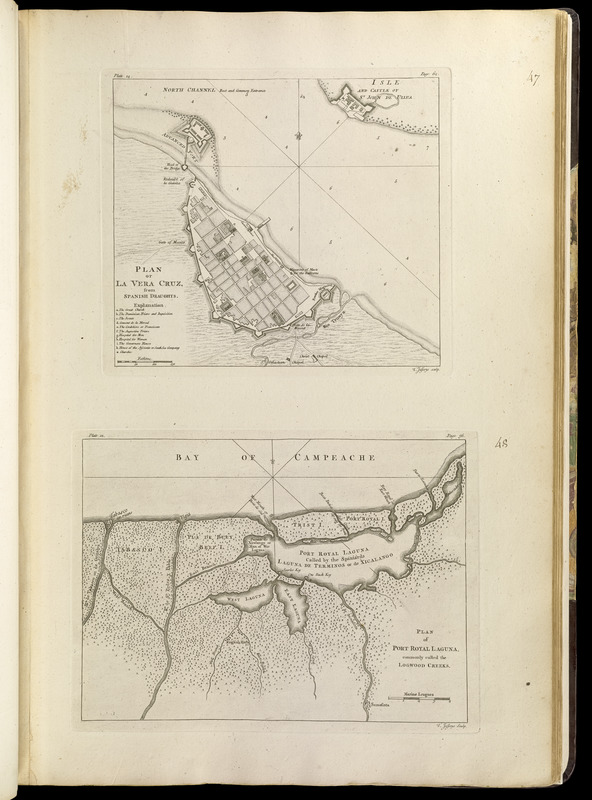
Plan of La Vera Cruz, from Spanish draughts ; Plan of Port Royal Laguna, commonly called Logwood Creeks
This map is also available in American Revolutionary Geographies Online (ARGO), a collections portal especially built for material relating to the American Revolutionary War Era. Visit ARGO to learn more about this item and explore the historical geography of North America in the late eighteenth century.
Item Information
- Title:
- Plan of La Vera Cruz, from Spanish draughts ; Plan of Port Royal Laguna, commonly called Logwood Creeks
- Creator:
- Jefferys, Thomas, -1771
- Publisher:
- Sayer, Robert, 1725-1794
- Name on Item:
-
T. Jefferys sculp.
- Date:
-
[1768]
- Format:
-
Maps/Atlases
- Location:
-
Boston Public Library
Norman B. Leventhal Map & Education Center - Collection (local):
-
Norman B. Leventhal Map & Education Center Collection
- Subjects:
-
Nautical charts--Mexico--Veracruz (Veracruz-Llave)--Early works to 1800
Terminos Lagoon (Mexico)--Maps--Early works to 1800
Veracruz (Veracruz-Llave, Mexico)--Maps--Early works to 1800
- Places:
-
MexicoVeracruzVeracruz
MexicoCampecheTérminos, Laguna de (lagoon)
- Extent:
- 2 maps on 1 sheet ; 21 x 24 cm. and 21 x 28 cm., on sheet 56 x 37 cm.
- Terms of Use:
-
No known copyright restrictions.
No known restrictions on use.
- Publisher:
-
London :
Printed for Robert Sayer, ... and Thomas Jefferys
- Scale:
-
Scale [ca. 1:7,100]
Scale [ca. 1:444,000]
- Language:
-
English
- Notes:
-
Depths shown by soundings.
Vera Cruz chart includes references.
In upper left of Vera Cruz chart: plate 14. In upper right: page 64.
In upper left of Port Royal chart: plate 12. In upper right: page 56.
Appears in Jefferys' General topography of North America and the West Indies. London: Printed for Robert Sayer, ... and Thomas Jefferys, 1768.
- Notes (date):
-
This date is inferred.
- Notes (citation):
-
LC Maps of North America, 2121
- Identifier:
-
4000137_0085
- Call #:
-
G1105 .J4 1768
- Barcode:
-
30000003255932