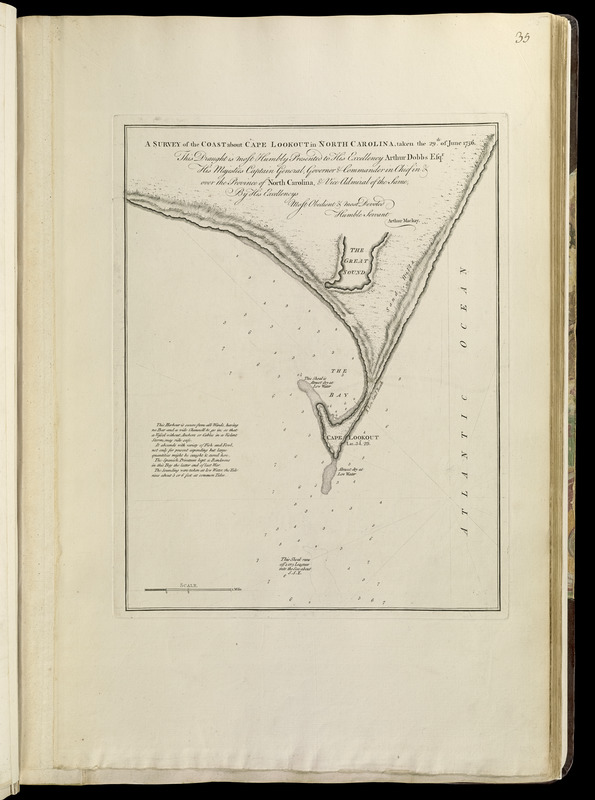
A survey of the coast about Cape Lookout in North Carolina, taken the 29th. of June 1756
This map is also available in American Revolutionary Geographies Online (ARGO), a collections portal especially built for material relating to the American Revolutionary War Era. Visit ARGO to learn more about this item and explore the historical geography of North America in the late eighteenth century.
Item Information
- Title:
- A survey of the coast about Cape Lookout in North Carolina, taken the 29th. of June 1756
- Creator:
- Mackay, Arthur
- Contributor:
- Jefferys, Thomas, -1771
- Contributor:
- Sayer, Robert, 1725-1794
- Name on Item:
-
this draught is most humbly presented to His Excellency Arthur Dobbs, Esqr., His Majesties Captain General, Governor & Commander in Chief in & over the Province of North Carolina, & Vice Admiral of the same, by his excellency's most obedient & devoted humble servant, Arthur Mackay
- Date:
-
[1768]
- Format:
-
Maps/Atlases
- Location:
-
Boston Public Library
Norman B. Leventhal Map & Education Center - Collection (local):
-
Norman B. Leventhal Map & Education Center Collection
- Subjects:
-
Nautical charts--North Carolina--Lookout, Cape--Early works to 1800
Lookout, Cape (N.C.)--Maps--Early works to 1800
- Places:
-
North CarolinaCarteret (county)Cape Lookout
- Extent:
- 1 map ; 35 x 27 cm.
- Terms of Use:
-
No known copyright restrictions.
No known restrictions on use.
- Publisher:
-
London :
Printed for Robert Sayer, ... and Thomas Jefferys
- Scale:
-
Scale [ca. 1:26,000]
- Language:
-
English
- Notes:
-
Relief shown by hachures. Depths shown by soundings.
Appears in Jefferys' General topography of North America and the West Indies. London: Printed for Robert Sayer, ... and Thomas Jefferys, 1768.
- Notes (date):
-
This date is inferred.
- Notes (citation):
-
Cumming, W.P. Southeast in early maps, 367
Phillips, 1196
- Identifier:
-
4000137_0070
- Call #:
-
G1105 .J4 1768
- Barcode:
-
30000003254684


