Toggle navigation
LMEC Home
Exhibitions
Georeferencing
Tools for Teachers
Collections
My Favorites
Sign Up / Log In
Search
Search the map portal
Map Collection
Map Collection
Map Sets
Search
Search
Search for
Search In
All Fields
Creator
Title
Subject
Place
Search All Digital Collections
Advanced Search
8748 Results
My Search
Start Over
More Like
commonwealth:cj82m310j
Remove constraint More Like: commonwealth:cj82m310j
Filter your Search
Place
North and Central America
5,978
United States
4,879
Massachusetts
2,079
Europe
1,396
Suffolk (county)
1,045
Boston
1,018
Canada
458
Asia
438
more
Place
»
Topic
Boston (Mass.)--Maps
586
United States--Maps
282
Real property--Massachusetts--Boston--Maps
175
Massachusetts--Maps
162
Landowners--Massachusetts--Boston--Maps
133
North America--Maps--Early works to 1800
106
New England--Maps
102
Europe--Maps
79
more
Topic
»
Date
Date range begin
–
Date range end
Current results range from
1482
to
2023
View distribution
Creator
United States. Hydrographic Office
595
O.H. Bailey & Co
148
Des Barres, Joseph F. W. (Joseph Frederick Wallet), 1722-1824
123
United States. Post Office Dept
120
Ptolemy, 2nd cent
100
Walling, Henry Francis, 1825-1888
94
Jefferys, Thomas, -1771
88
Geological Survey (U.S.)
86
more
Creator
»
Format
Maps/Atlases
8,688
Manuscripts
217
Prints
56
Books
36
Objects/Artifacts
10
Drawings/Illustrations
8
Posters
5
Georeferenced
Yes
870
No
7,878
Collection
Norman B. Leventhal Map & Education Center Collection
8,705
Boston and New England Maps
2,232
Urban Maps
2,023
Maritime Charts and Atlases
1,086
American Revolutionary War-Era Maps
655
Boston Redevelopment Authority Collection
87
New York Public Library Collection
14
Mapping Boston Collection
12
more
Collection
»
Available to use
No known restrictions
8,553
Creative Commons license
83
Search Constraints
Sort by relevance
relevance
title
date (asc)
date (desc)
Number of results to display per page
20 per page
10
per page
20
per page
50
per page
100
per page
View results as:
grid view
map view
Search Results
21.
New Engelland, New York, New Yersey und Pensilvania
22.
Nova Anglia Novum Belgium et Virginia
23.
Nova Anglia, Novum Belgium et Virginia
24.
Nova Anglia Septentrionali Americae implantata Anglorumque coloniis florentissima geographicè exhibita
25.
Nova Belgica et Anglia Nova
26.
Pas caert van Nieu Nederland, Virginia en Nieu Engelant
27.
Pas caerte van Nieu Nederlandt en de Engelsche Virginies van Cabo Cod tot Cabo Canrick
28.
Pensylvania Nova Jersey et Nova York cum Regionibus ad Fluvium Delaware in America sitis
29.
The provinces of New York and New Jersey : with part of Pensilvania, and the Province of Quebec
30.
Virginia, Maryland, Pennsilvania, east & west New Jarsey
31.
Theodolite's pattern, shewing the provinces in North America which were in the respective possessions of England, France &...
32.
Belgii Novi, Angliae Novae, et partis Virginiae : novissima delineatio
33.
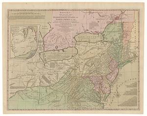
Bowles's new pocket map of the following independent states of North America, viz. Virginia, Maryland, Delaware, Pensylvania,...
34.
Carta della Nuova Inghilterra, Nuova Yorc, e Pensilvania
35.
Carte de la Nouvelle Angleterre, Nouvelle Yorck, et Pensilvanie : pour servir à l'Histoire générale des voyages
36.
Carte de la Nouvelle Angleterre, Nouvelle York, Nouvelle Jersey et Pensilvanie
37.
Carte de la partie nord, des Etats Unis, de l'Amérique Septentrionale
38.
Carte des Etats-unis : provinces septentrionales
39.
Carte des pays connus sous le nom de Canada dans laquelle sont distinguées les possessions françoises, & angl' : dediée et...
40.
Carte d'une partie du Nord Amerique dans la quelle se trouvent les isles et les provinces suivantes : l'Isle de la Terre-Neuve...
‹ Prev
Next ›
1
2
3
4
5
6
…
437
438