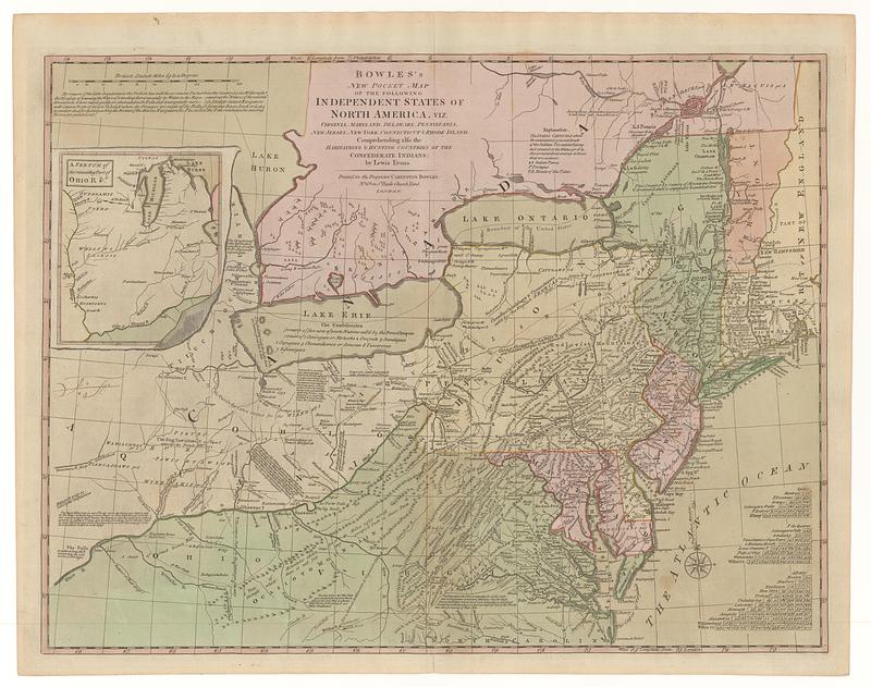
Bowles's new pocket map of the following independent states of North America, viz. Virginia, Maryland, Delaware, Pensylvania, New Jersey, New York, Connecticut & Rhode Island : comprehending also the habitations & hunting countries of the confederate Indians
This map is also available in American Revolutionary Geographies Online (ARGO), a collections portal especially built for material relating to the American Revolutionary War Era. Visit ARGO to learn more about this item and explore the historical geography of North America in the late eighteenth century.
Item Information
- Title:
- Bowles's new pocket map of the following independent states of North America, viz. Virginia, Maryland, Delaware, Pensylvania, New Jersey, New York, Connecticut & Rhode Island : comprehending also the habitations & hunting countries of the confederate Indians
- Creator:
- Evans, Lewis, 1700?-1756
- Publisher:
- Bowles, John, 1701-1779
- Publisher:
- Bowles, Carington, 1724-1793
- Name on Item:
-
by Lewis Evans
- Date:
-
[ca. 1783]
- Format:
-
Maps/Atlases
- Location:
- MacLean Collection Map Library
- Collection (local):
-
MacLean Collection Map Library
- Subjects:
-
Northeastern States--Maps--Early works to 1800
Indians of North America--Maps--Early works to 1800
- Places:
-
Northeastern United States (area)
- Extent:
- 1 map ; 491 x 644 mm
- Terms of Use:
-
Public Domain/No known restrictions on use. Contact host institution to download image.
Contact host institution for more information.
- Publisher:
-
London :
Printed for the proprietor Carington Bowles, n.o 69 in S.t Pauls Church Yard
- Language:
-
English
- Identifier:
-
MC_3071
- Call #:
-
3071